Property Record
31 Highway 285 Rd S, Damascus, AR 72039

This Property Is For Sale
Property Detail
31 Highway 285 Rd S
790-00153-001
PT NE SE WOOSTER FIRE DIST 67
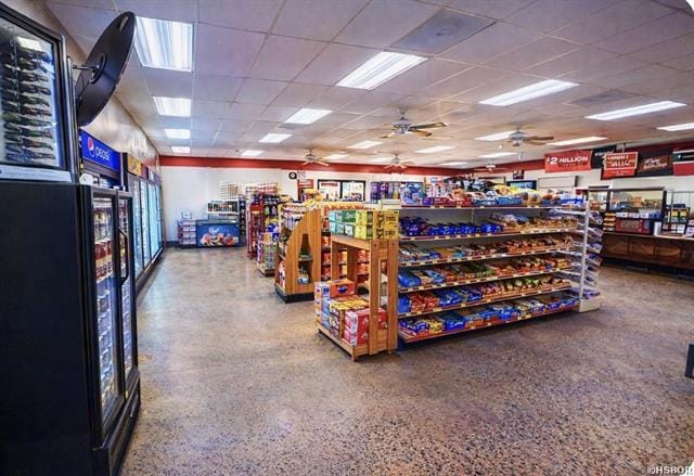
Storebuilding
FAULKNER
B and X Area of moderate flood hazard, usually the area between the limits of the 100-year and 500-year floods.
Arkansas
2025
1.07 AC
2025
Faulkner County
460400
Little Rock/N Little Rock
4,200 SF
Little Rock-North Little Rock-Conway, AR
NEARBY LISTINGS FOR SALE OR LEASE
-
-
View all Damascus listings for sale on LoopNet.com
DEMOGRAPHICS near 31 Highway 285 Rd S
1 mile
3 mile
5 mile
2025 Total Population
930
5,012
14,204
2030 Population
989
5,322
15,103
Pop Growth 2025-2030
+ 6.34%
+ 6.19%
+ 6.33%
Average Age
39
39
39
2025 Total Households
333
1,793
5,172
HH Growth 2025-2030
+ 6.61%
+ 6.47%
+ 6.55%
Median Household Inc
$112,999
$111,942
$95,506
Avg Household Size
2.80
2.80
2.70
2025 Avg HH Vehicles
2.00
2.00
2.00
Median Home Value
$327,272
$320,312
$274,327
Median Year Built
1999
1999
2000
Nearby Places
Map Layers
Map Styles
 Street
 Aerial
Layers
 Traffic
 Biking
Places
Listings with unknown addresses are not visible on the map
- Restaurants
- Banks
- Shops
- Fitness
- Groceries
Nearby Properties
Address
Land Use
TOTAL SIZE
Lot Size
Zoning
Address
Land Use
TOTAL SIZE
Lot Size
Zoning
25,200 SF
13.50 AC
Address
Land Use
TOTAL SIZE
Lot Size
Zoning
1,891 SF
4.04 AC
Address
Land Use
TOTAL SIZE
Lot Size
Zoning
12,892 SF
3.97 AC
Address
Land Use
TOTAL SIZE
Lot Size
Zoning
13,500 SF
40.50 AC
Address
Land Use
TOTAL SIZE
Lot Size
Zoning
9,360 SF
1.08 AC
Address
Land Use
TOTAL SIZE
Lot Size
Zoning
15,000 SF
2.42 AC
Address
Land Use
TOTAL SIZE
Lot Size
Zoning
15,900 SF
1.30 AC
Address
Land Use
TOTAL SIZE
Lot Size
Zoning
6,710 SF
1.87 AC
Address
Land Use
TOTAL SIZE
Lot Size
Zoning
14,345 SF
1.57 AC
Address
Land Use
TOTAL SIZE
Lot Size
Zoning
4,018 SF
4.38 AC
Address
Land Use
TOTAL SIZE
Lot Size
Zoning
11,550 SF
0.90 AC
Address
Land Use
TOTAL SIZE
Lot Size
Zoning
2,912 SF
1 AC
Address
Land Use
TOTAL SIZE
Lot Size
Zoning
4,998 SF
0.67 AC
Address
Land Use
TOTAL SIZE
Lot Size
Zoning
2,508 SF
0.99 AC
Address
Land Use
TOTAL SIZE
Lot Size
Zoning
2,508 SF
1.01 AC
Address
Land Use
TOTAL SIZE
Lot Size
Zoning
2,508 SF
0.89 AC
Address
Land Use
TOTAL SIZE
Lot Size
Zoning
2,508 SF
1.01 AC
Address
Land Use
TOTAL SIZE
Lot Size
Zoning
2,508 SF
0.77 AC
Address
Land Use
TOTAL SIZE
Lot Size
Zoning
9,000 SF
1.03 AC
Address
Land Use
TOTAL SIZE
Lot Size
Zoning
2,320 SF
0.51 AC
Address
Land Use
TOTAL SIZE
Lot Size
Zoning
558 SF
2.10 AC
Address
Land Use
TOTAL SIZE
Lot Size
Zoning
11,090 SF
2.53 AC
Address
Land Use
TOTAL SIZE
Lot Size
Zoning
Address
Land Use
TOTAL SIZE
Lot Size
Zoning
Address
Land Use
TOTAL SIZE
Lot Size
Zoning
Address
Land Use
TOTAL SIZE
Lot Size
Zoning
4.15 AC
Address
Land Use
TOTAL SIZE
Lot Size
Zoning
4.39 AC
Address
Land Use
TOTAL SIZE
Lot Size
Zoning
4.11 AC
Address
Land Use
TOTAL SIZE
Lot Size
Zoning
1,633 SF
1.16 AC
The World's #1 Commercial Real Estate Marketplace
Connect with us
© 2026 CoStar Group
The information above has been obtained from sources believed reliable. While we do not doubt its accuracy we have not verified it and make no guarantee, warranty or representation about it. It is your responsibility to independently confirm its accuracy and completeness. Any projections, opinions, assumptions, or estimates used are for example only and do not represent the current or future performance of the property. The value of this transaction to you depends on tax and other factors which should be evaluated by your tax, financial, and legal advisors. You and your advisors should conduct a careful, independent investigation of the property to determine to your satisfaction the suitability of the property for your needs.