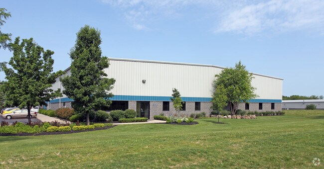
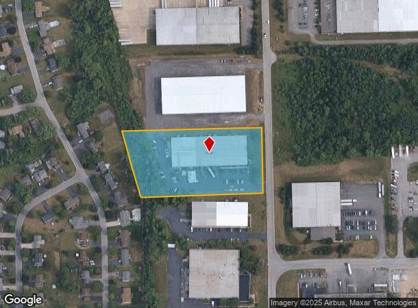
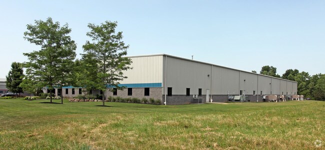
Property Record
31 Jetview Dr, Rochester, NY 14624
NEARBY LISTINGS FOR SALE OR LEASE
Property Detail
31 Jetview Dr
262200-147-060-0001-017-110
L28 T2 R1 JETVIEW SEC 1 RESUB LOT R-110A
Manufacturinglight
Monroe
X
New York
36055C0327G
17.110
2025
3.38 AC
2024
Southwest
014504
Rochester
37,850 SF
Rochester, NY
DEMOGRAPHICS near 31 Jetview Dr
1 Mile
3 Mile
5 Mile
2024 Total Population
3,552
39,175
140,168
2029 Population
3,483
38,541
138,168
Pop Growth 2024-2029
(1.94%)
(1.62%)
(1.43%)
Average Age
43
39
38
2024 Total Households
1,382
13,946
55,484
HH Growth 2024-2029
(2.03%)
(1.88%)
(1.56%)
Median Household Inc
$91,235
$72,195
$56,612
Avg Household Size
2.50
2.30
2.30
2024 Avg HH Vehicles
2.00
2.00
2.00
Median Home Value
$167,639
$150,126
$144,292
Median Year Built
1975
1964
1962
Nearby Places
- Restaurants
- Banks
- Shops
- Fitness
- Groceries
PUBLIC TRANSPORTATION
COMMUTER RAIL
Rochester (Empire Service - VIA Rail, Lake Shore Limited - VIA Rail, Maple Leaf - VIA Rail, Toronto - New York - VIA Rail)
DRIVE
WALK
Distance
Rochester (Empire Service - VIA Rail, Lake Shore Limited - VIA Rail, Maple Leaf - VIA Rail, Toronto - New York - VIA Rail)
15 min
7.1 mi
AIRPORT
Frederick Douglass/Greater Rochester International
DRIVE
WALK
Distance
Frederick Douglass/Greater Rochester International
7 min
2.9 mi
Freight Ports
Albany, NY Port
DRIVE
WALK
Distance
Albany, NY Port
277 min
230.8 mi
Nearby Properties
Address
Land Use
TOTAL SIZE
Lot Size
Zoning
Address
Land Use
TOTAL SIZE
Lot Size
Zoning
111,601 SF
225.15 AC
Address
Land Use
TOTAL SIZE
Lot Size
Zoning
216,267 SF
112.82 AC
02 - SINGL
Address
Land Use
TOTAL SIZE
Lot Size
Zoning
Address
Land Use
TOTAL SIZE
Lot Size
Zoning
446,748 SF
14.10 AC
06 - INDUS
Address
Land Use
TOTAL SIZE
Lot Size
Zoning
Address
Land Use
TOTAL SIZE
Lot Size
Zoning
628,572 SF
134.14 AC
06 - INDUS
Address
Land Use
TOTAL SIZE
Lot Size
Zoning
200,000 SF
764.91 AC
Address
Land Use
TOTAL SIZE
Lot Size
Zoning
172,517 SF
29.57 AC
Address
Land Use
TOTAL SIZE
Lot Size
Zoning
55,400 SF
619.27 AC
Address
Land Use
TOTAL SIZE
Lot Size
Zoning
11,408 SF
98.28 AC
02 - SINGL
Address
Land Use
TOTAL SIZE
Lot Size
Zoning
37,632 SF
29.06 AC
06 - INDUS
Address
Land Use
TOTAL SIZE
Lot Size
Zoning
522,321 SF
95.70 AC
06 - INDUS
Address
Land Use
TOTAL SIZE
Lot Size
Zoning
86,138 SF
7.54 AC
Address
Land Use
TOTAL SIZE
Lot Size
Zoning
540,000 SF
39.70 AC
06 - INDUS
Address
Land Use
TOTAL SIZE
Lot Size
Zoning
63,134 SF
7.46 AC
02 - SINGL
Address
Land Use
TOTAL SIZE
Lot Size
Zoning
3,780 SF
33.10 AC
02 - SINGL
Address
Land Use
TOTAL SIZE
Lot Size
Zoning
1,440 SF
5.40 AC
02 - SINGL
Address
Land Use
TOTAL SIZE
Lot Size
Zoning
97,320 SF
19.54 AC
05 - COMME
Address
Land Use
TOTAL SIZE
Lot Size
Zoning
201,774 SF
17.17 AC
05 - COMME
Address
Land Use
TOTAL SIZE
Lot Size
Zoning
1,802 SF
15.80 AC
06 - INDUS
Address
Land Use
TOTAL SIZE
Lot Size
Zoning
99,886 SF
18.28 AC
05 - COMME
Address
Land Use
TOTAL SIZE
Lot Size
Zoning
22,116 SF
42.83 AC
02 - SINGL
Address
Land Use
TOTAL SIZE
Lot Size
Zoning
119,706 SF
16.43 AC
05 - COMME
Address
Land Use
TOTAL SIZE
Lot Size
Zoning
127,786 SF
11.31 AC
05 - COMME
Address
Land Use
TOTAL SIZE
Lot Size
Zoning
290 AC
06 - INDUS
Address
Land Use
TOTAL SIZE
Lot Size
Zoning
134,965 SF
17.50 AC
05 - COMME
Address
Land Use
TOTAL SIZE
Lot Size
Zoning
23,940 SF
6.45 AC
05 - COMME
Address
Land Use
TOTAL SIZE
Lot Size
Zoning
44,132 SF
30.45 AC
06 - INDUS
Address
Land Use
TOTAL SIZE
Lot Size
Zoning
7,225 SF
470.80 AC
Address
Land Use
TOTAL SIZE
Lot Size
Zoning
62,915 SF
6.77 AC
02 - SINGL
The World's #1 Commercial Real Estate Marketplace
Connect with us
© 2025 CoStar Group
The information above has been obtained from sources believed reliable. While we do not doubt its accuracy we have not verified it and make no guarantee, warranty or representation about it. It is your responsibility to independently confirm its accuracy and completeness. Any projections, opinions, assumptions, or estimates used are for example only and do not represent the current or future performance of the property. The value of this transaction to you depends on tax and other factors which should be evaluated by your tax, financial, and legal advisors. You and your advisors should conduct a careful, independent investigation of the property to determine to your satisfaction the suitability of the property for your needs.