Property Record
31 Kringle Dr, Bernardston, MA 01337

Save to a Folder
{{folder.Name}}
{{folder.ListingIds.length}} Properties
{{folder.ListingIds.length}} Property
Create a New Folder
Property Detail
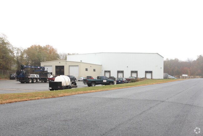
31 Kringle Dr
BERN-000090-000001-000030
FRANKLIN
Manufacturinglight
Massachusetts
I
30
2025
5 AC
2025
Franklin County
040200
Hartford
54,998 SF
Greenfield, MA
NEARBY LISTINGS FOR SALE OR LEASE
-
-
View all Bernardston listings for sale on LoopNet.com
DEMOGRAPHICS near 31 Kringle Dr
1 mile
3 mile
5 mile
2025 Total Population
1,004
3,370
12,150
2030 Population
998
3,358
12,037
Pop Growth 2025-2030
(0.60%)
(0.36%)
(0.93%)
Average Age
48
48
46
2025 Total Households
438
1,440
5,279
HH Growth 2025-2030
(0.91%)
(0.42%)
(0.99%)
Median Household Inc
$85,080
$88,364
$77,138
Avg Household Size
2.30
2.30
2.20
2025 Avg HH Vehicles
2.00
2.00
2.00
Median Home Value
$339,595
$338,632
$326,503
Median Year Built
1970
1969
1956
Nearby Places
Map Layers
Map Styles
 Street
 Aerial
Layers
 Traffic
 Biking
Places
Listings with unknown addresses are not visible on the map
- Restaurants
- Banks
- Shops
- Fitness
- Groceries
PUBLIC TRANSPORTATION
COMMUTER RAIL
Greenfield Amtrak Station (Valley Flyer - Amtrak, Vermonter - Amtrak)
Drive
Walk
Distance
Greenfield Amtrak Station (Valley Flyer - Amtrak, Vermonter - Amtrak)
10 min
7.2 mi
Freight Ports
Albany, NY Port
Drive
Walk
Distance
Albany, NY Port
143 min
118.5 mi
Nearby Properties
Address
Land Use
TOTAL SIZE
Lot Size
Zoning
Address
Land Use
TOTAL SIZE
Lot Size
Zoning
29 AC
RA
Address
Land Use
TOTAL SIZE
Lot Size
Zoning
68,667 SF
15 AC
B
Address
Land Use
TOTAL SIZE
Lot Size
Zoning
32,409 SF
12 AC
RA
Address
Land Use
TOTAL SIZE
Lot Size
Zoning
15,784 SF
2 AC
R1
Address
Land Use
TOTAL SIZE
Lot Size
Zoning
50,400 SF
3.23 AC
GC
Address
Land Use
TOTAL SIZE
Lot Size
Zoning
4,000 SF
8 AC
B
Address
Land Use
TOTAL SIZE
Lot Size
Zoning
24,020 SF
5 AC
B
Address
Land Use
TOTAL SIZE
Lot Size
Zoning
9,460 SF
482 AC
RA
Address
Land Use
TOTAL SIZE
Lot Size
Zoning
297 AC
R1
Address
Land Use
TOTAL SIZE
Lot Size
Zoning
17,088 SF
13.30 AC
Address
Land Use
TOTAL SIZE
Lot Size
Zoning
10,398 SF
1 AC
CV
Address
Land Use
TOTAL SIZE
Lot Size
Zoning
20,673 SF
2 AC
R1
Address
Land Use
TOTAL SIZE
Lot Size
Zoning
16,562 SF
3 AC
R1
Address
Land Use
TOTAL SIZE
Lot Size
Zoning
24,908 SF
3 AC
I
Address
Land Use
TOTAL SIZE
Lot Size
Zoning
13,188 SF
2.11 AC
GC
Address
Land Use
TOTAL SIZE
Lot Size
Zoning
8,640 SF
2 AC
B
Address
Land Use
TOTAL SIZE
Lot Size
Zoning
5,470 SF
2 AC
CV
Address
Land Use
TOTAL SIZE
Lot Size
Zoning
3,301 SF
6.62 AC
Address
Land Use
TOTAL SIZE
Lot Size
Zoning
9,704 SF
10 AC
I
Address
Land Use
TOTAL SIZE
Lot Size
Zoning
10,221 SF
13.67 AC
GC
Address
Land Use
TOTAL SIZE
Lot Size
Zoning
23,038 SF
32.44 AC
GC
Address
Land Use
TOTAL SIZE
Lot Size
Zoning
7,128 SF
2 AC
Address
Land Use
TOTAL SIZE
Lot Size
Zoning
15,540 SF
4 AC
B
Address
Land Use
TOTAL SIZE
Lot Size
Zoning
2,264 SF
131.45 AC
RC
Address
Land Use
TOTAL SIZE
Lot Size
Zoning
4,400 SF
0.31 AC
Address
Land Use
TOTAL SIZE
Lot Size
Zoning
4,920 SF
46 AC
I
Address
Land Use
TOTAL SIZE
Lot Size
Zoning
9,858 SF
5 AC
I
Address
Land Use
TOTAL SIZE
Lot Size
Zoning
18,616 SF
4.93 AC
RC
Address
Land Use
TOTAL SIZE
Lot Size
Zoning
40 AC
RA
The World's #1 Commercial Real Estate Marketplace
Connect with us
© 2026 CoStar Group
The information above has been obtained from sources believed reliable. While we do not doubt its accuracy we have not verified it and make no guarantee, warranty or representation about it. It is your responsibility to independently confirm its accuracy and completeness. Any projections, opinions, assumptions, or estimates used are for example only and do not represent the current or future performance of the property. The value of this transaction to you depends on tax and other factors which should be evaluated by your tax, financial, and legal advisors. You and your advisors should conduct a careful, independent investigation of the property to determine to your satisfaction the suitability of the property for your needs.