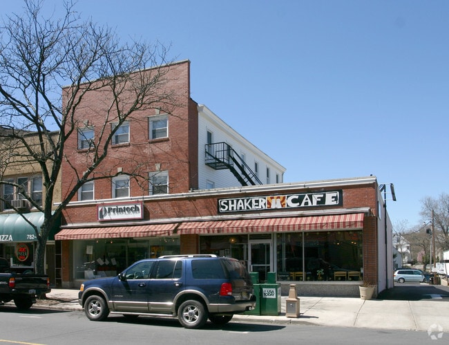
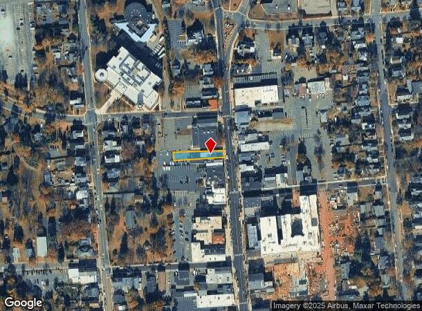
Property Record
31 Main St, Flemington, NJ 08822

NEARBY LISTINGS FOR SALE OR LEASE
Property Detail
31 Main St
09-00017-0000-00012
Hunterdon
Vacantlandnec
New Jersey
X
12
34019C0263F
0.17 AC
2024
Hunterdon
2025
Northern New Jersey
011400
Newark, NJ
2,232 SF
DEMOGRAPHICS near 31 Main St
1 Mile
3 Mile
5 Mile
2024 Total Population
8,183
25,640
37,767
2029 Population
8,433
26,272
38,471
Pop Growth 2024-2029
+ 3.06%
+ 2.46%
+ 1.86%
Average Age
39
42
43
2024 Total Households
3,117
9,711
14,106
HH Growth 2024-2029
+ 2.98%
+ 2.46%
+ 1.88%
Median Household Inc
$90,012
$113,740
$127,865
Avg Household Size
2.60
2.60
2.60
2024 Avg HH Vehicles
2.00
2.00
2.00
Median Home Value
$375,114
$434,667
$469,957
Median Year Built
1973
1983
1983
Nearby Places
Map Layers
Map Styles
 Street
 Aerial
- Restaurants
- Banks
- Shops
- Fitness
- Groceries
PUBLIC TRANSPORTATION
COMMUTER RAIL
Annandale (Raritan Valley Line - NJ Transit Commuter Rail (NJ Transit))
DRIVE
WALK
Distance
Annandale (Raritan Valley Line - NJ Transit Commuter Rail (NJ Transit))
15 min
9.6 mi
White House (Raritan Valley Line - NJ Transit Commuter Rail (NJ Transit))
DRIVE
WALK
Distance
White House (Raritan Valley Line - NJ Transit Commuter Rail (NJ Transit))
15 min
9.7 mi
Freight Ports
New York Container Terminal
DRIVE
WALK
Distance
New York Container Terminal
1 min
36.5 mi
SALE & LEASE HISTORY
LISTING DATE
SALE/LEASE

Jan 28, 2020
For Sale
Jan 09, 2019
For Sale
Jan 08, 2019
For Sale
Nearby Properties
Address
Land Use
TOTAL SIZE
Lot Size
Zoning
Address
Land Use
TOTAL SIZE
Lot Size
Zoning
34.80 AC
H
Address
Land Use
TOTAL SIZE
Lot Size
Zoning
68.38 AC
P
Address
Land Use
TOTAL SIZE
Lot Size
Zoning
7.88 AC
CR
Address
Land Use
TOTAL SIZE
Lot Size
Zoning
39.32 AC
P
Address
Land Use
TOTAL SIZE
Lot Size
Zoning
65.10 AC
I-1
Address
Land Use
TOTAL SIZE
Lot Size
Zoning
19.85 AC
B-2
Address
Land Use
TOTAL SIZE
Lot Size
Zoning
10,546 SF
12.75 AC
GA
Address
Land Use
TOTAL SIZE
Lot Size
Zoning
12,208 SF
11 AC
GA
Address
Land Use
TOTAL SIZE
Lot Size
Zoning
11.90 AC
CR
Address
Land Use
TOTAL SIZE
Lot Size
Zoning
11.59 AC
B-2
Address
Land Use
TOTAL SIZE
Lot Size
Zoning
23.84 AC
I-2
Address
Land Use
TOTAL SIZE
Lot Size
Zoning
20.89 AC
O/SS
Address
Land Use
TOTAL SIZE
Lot Size
Zoning
26.03 AC
I-2
Address
Land Use
TOTAL SIZE
Lot Size
Zoning
108.22 AC
I-2
Address
Land Use
TOTAL SIZE
Lot Size
Zoning
54.74 AC
P
Address
Land Use
TOTAL SIZE
Lot Size
Zoning
1,418 SF
19.67 AC
P
Address
Land Use
TOTAL SIZE
Lot Size
Zoning
4.34 AC
PO
Address
Land Use
TOTAL SIZE
Lot Size
Zoning
12.75 AC
B-2
Address
Land Use
TOTAL SIZE
Lot Size
Zoning
11.58 AC
P
Address
Land Use
TOTAL SIZE
Lot Size
Zoning
0.75 AC
H
Address
Land Use
TOTAL SIZE
Lot Size
Zoning
31.46 AC
R-3
Address
Land Use
TOTAL SIZE
Lot Size
Zoning
4.51 AC
R-3
Address
Land Use
TOTAL SIZE
Lot Size
Zoning
16.01 AC
I-2
Address
Land Use
TOTAL SIZE
Lot Size
Zoning
7.99 AC
CR
Address
Land Use
TOTAL SIZE
Lot Size
Zoning
8.07 AC
I-2
Address
Land Use
TOTAL SIZE
Lot Size
Zoning
5.47 AC
B-2
Address
Land Use
TOTAL SIZE
Lot Size
Zoning
13.56 AC
CR
Address
Land Use
TOTAL SIZE
Lot Size
Zoning
2,826 SF
6.28 AC
B-2
Address
Land Use
TOTAL SIZE
Lot Size
Zoning
7.75 AC
HR
Address
Land Use
TOTAL SIZE
Lot Size
Zoning
38.30 AC
O-2
The World's #1 Commercial Real Estate Marketplace
Connect with us
© 2026 CoStar Group
The information above has been obtained from sources believed reliable. While we do not doubt its accuracy we have not verified it and make no guarantee, warranty or representation about it. It is your responsibility to independently confirm its accuracy and completeness. Any projections, opinions, assumptions, or estimates used are for example only and do not represent the current or future performance of the property. The value of this transaction to you depends on tax and other factors which should be evaluated by your tax, financial, and legal advisors. You and your advisors should conduct a careful, independent investigation of the property to determine to your satisfaction the suitability of the property for your needs.