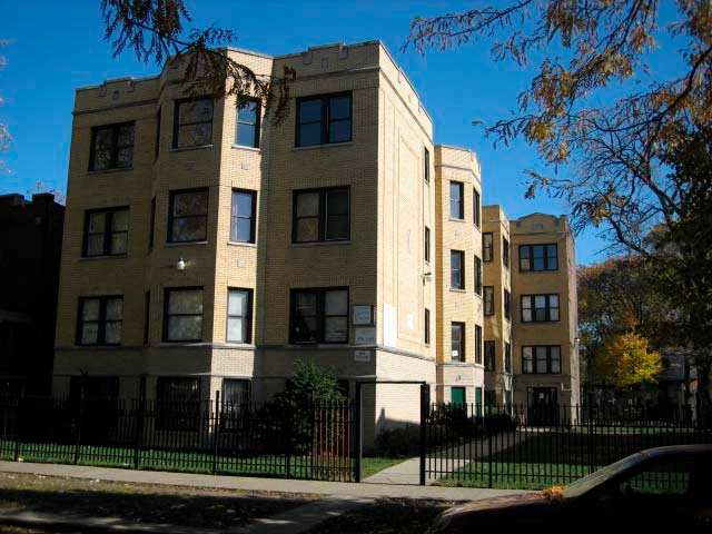
Property Record
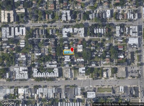
31 N Lorel Ave, Chicago, IL 60644


NEARBY LISTINGS FOR SALE OR LEASE
Property Detail
31 N Lorel Ave
Chicago-Naperville-Elgin, IL-IN-WI
Davis Sub
16-09-322-007-0000
WILBUR R (DAVIS) SUB WH SH EH WH SE SW SEC 09-39-13
Apartment
Cook
X
Illinois
17031C0395J
5,6
2023
0.14 AC
2024
Austin
251900
Chicago
13,422 SF
DEMOGRAPHICS near 31 N Lorel Ave
1 Mile
3 Mile
5 Mile
2024 Total Population
38,852
336,934
846,106
2029 Population
36,512
315,176
794,728
Pop Growth 2024-2029
(6.02%)
(6.46%)
(6.07%)
Average Age
38
38
37
2024 Total Households
14,800
121,088
310,061
HH Growth 2024-2029
(6.42%)
(6.53%)
(6.23%)
Median Household Inc
$31,930
$52,556
$65,540
Avg Household Size
2.50
2.70
2.60
2024 Avg HH Vehicles
1.00
1.00
1.00
Median Home Value
$238,248
$275,119
$304,803
Median Year Built
1947
1947
1947
Nearby Places
Map Layers
Map Styles
 Street
 Aerial
- Restaurants
- Banks
- Shops
- Fitness
- Groceries
PUBLIC TRANSPORTATION
TRANSIT/SUBWAY
Laramie Station (Green Line - Chicago Transit Authority "L" Trains (The "L"))
DRIVE
WALK
Distance
Laramie Station (Green Line - Chicago Transit Authority "L" Trains (The "L"))
3 min
12 min
0.7 mi
Central Station (Green Line) (Green Line - Chicago Transit Authority "L" Trains (The "L"))
DRIVE
WALK
Distance
Central Station (Green Line) (Green Line - Chicago Transit Authority "L" Trains (The "L"))
4 min
17 min
0.9 mi
COMMUTER RAIL
Oak Park Station (Union Pacific West Line - Northeast Illinois Regional Commuter Railroad (Metra))
DRIVE
WALK
Distance
Oak Park Station (Union Pacific West Line - Northeast Illinois Regional Commuter Railroad (Metra))
10 min
2.8 mi
Grand/Cicero Station (Milwaukee District West Line - Northeast Illinois Regional Commuter Railroad (Metra), North Central Service - Northeast Illinois Regional Commuter Railroad (Metra))
DRIVE
WALK
Distance
Grand/Cicero Station (Milwaukee District West Line - Northeast Illinois Regional Commuter Railroad (Metra), North Central Service - Northeast Illinois Regional Commuter Railroad (Metra))
13 min
3.3 mi
AIRPORT
Chicago Midway International
DRIVE
WALK
Distance
Chicago Midway International
23 min
7.5 mi
Chicago O'Hare International
DRIVE
WALK
Distance
Chicago O'Hare International
29 min
21.5 mi
Freight Ports
Port of Baltimore
DRIVE
WALK
Distance
Port of Baltimore
1 min
612.6 mi
SALE & LEASE HISTORY
LISTING DATE
SALE/LEASE

Sep 23, 2016
For Sale
Feb 06, 2019
For Sale
Aug 30, 2017
For Sale
Apr 23, 2025
For Sale
Nearby Properties
Address
Land Use
TOTAL SIZE
Lot Size
Zoning
Address
Land Use
TOTAL SIZE
Lot Size
Zoning
73,700 SF
0.48 AC
RM-6.5
Address
Land Use
TOTAL SIZE
Lot Size
Zoning
86,928 SF
4.80 AC
PD 933
Address
Land Use
TOTAL SIZE
Lot Size
Zoning
1,313,541 SF
44.90 AC
M2-2
Address
Land Use
TOTAL SIZE
Lot Size
Zoning
1,220,173 SF
26.53 AC
M2-2
Address
Land Use
TOTAL SIZE
Lot Size
Zoning
6.31 AC
PD 1013
Address
Land Use
TOTAL SIZE
Lot Size
Zoning
233,538 SF
0.68 AC
Address
Land Use
TOTAL SIZE
Lot Size
Zoning
3.33 AC
PD 1013
Address
Land Use
TOTAL SIZE
Lot Size
Zoning
32,500 SF
0.56 AC
RT-4
Address
Land Use
TOTAL SIZE
Lot Size
Zoning
459,659 SF
Address
Land Use
TOTAL SIZE
Lot Size
Zoning
194,582 SF
12.68 AC
PD 699
Address
Land Use
TOTAL SIZE
Lot Size
Zoning
0.58 AC
B3-2
Address
Land Use
TOTAL SIZE
Lot Size
Zoning
291,681 SF
14.04 AC
Address
Land Use
TOTAL SIZE
Lot Size
Zoning
10,400 SF
0.20 AC
B3-5
Address
Land Use
TOTAL SIZE
Lot Size
Zoning
226,155 SF
5.86 AC
PMD 9
Address
Land Use
TOTAL SIZE
Lot Size
Zoning
3.26 AC
Address
Land Use
TOTAL SIZE
Lot Size
Zoning
106,830 SF
1.59 AC
Address
Land Use
TOTAL SIZE
Lot Size
Zoning
578,024 SF
31.94 AC
Address
Land Use
TOTAL SIZE
Lot Size
Zoning
0.66 AC
PD 852
Address
Land Use
TOTAL SIZE
Lot Size
Zoning
93,409 SF
2.05 AC
PD 146
Address
Land Use
TOTAL SIZE
Lot Size
Zoning
141,800 SF
3.77 AC
Address
Land Use
TOTAL SIZE
Lot Size
Zoning
389,400 SF
28.83 AC
PMD 9
Address
Land Use
TOTAL SIZE
Lot Size
Zoning
897,723 SF
23.04 AC
PMD 15
Address
Land Use
TOTAL SIZE
Lot Size
Zoning
1,300 SF
0.07 AC
B3-5
Address
Land Use
TOTAL SIZE
Lot Size
Zoning
9,000 SF
0.34 AC
Address
Land Use
TOTAL SIZE
Lot Size
Zoning
89,919 SF
2.87 AC
Address
Land Use
TOTAL SIZE
Lot Size
Zoning
7.68 AC
Address
Land Use
TOTAL SIZE
Lot Size
Zoning
900 SF
29.73 AC
PD 1454
Address
Land Use
TOTAL SIZE
Lot Size
Zoning
0.41 AC
RT-4
Address
Land Use
TOTAL SIZE
Lot Size
Zoning
62,844 SF
3.24 AC
Address
Land Use
TOTAL SIZE
Lot Size
Zoning
15.25 AC
The World's #1 Commercial Real Estate Marketplace
Connect with us
© 2025 CoStar Group
The information above has been obtained from sources believed reliable. While we do not doubt its accuracy we have not verified it and make no guarantee, warranty or representation about it. It is your responsibility to independently confirm its accuracy and completeness. Any projections, opinions, assumptions, or estimates used are for example only and do not represent the current or future performance of the property. The value of this transaction to you depends on tax and other factors which should be evaluated by your tax, financial, and legal advisors. You and your advisors should conduct a careful, independent investigation of the property to determine to your satisfaction the suitability of the property for your needs.