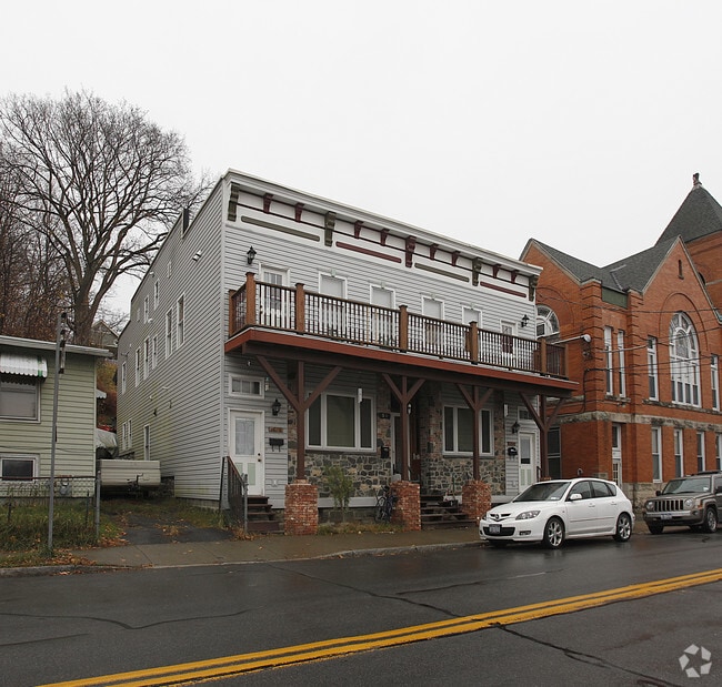
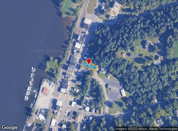
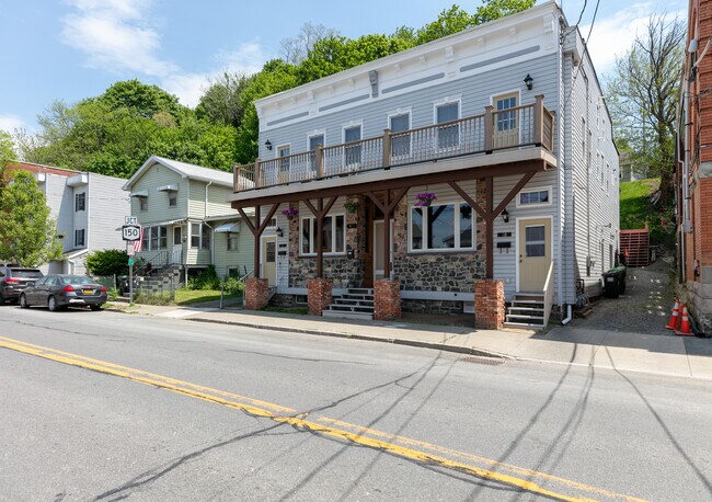
Property Record
31 S Main St, Castleton, NY 12033
NEARBY LISTINGS FOR SALE OR LEASE
-
-
View all Castleton listings for sale on LoopNet.com
Property Detail
31 S Main St
4401-198.15-1-30
COM & 2 FAMILY 299 AS OF 7-9-04
Commercialbuilding
Rensselaer
ARE
New York
36083C0344D
30.000
2025
0.18 AC
2024
Outer Rensselaer County
052503
Albany/Schenectady/Troy
5,200 SF
Albany-Schenectady-Troy, NY
DEMOGRAPHICS near 31 S Main St
1 Mile
3 Mile
5 Mile
2024 Total Population
1,756
5,998
21,313
2029 Population
1,760
5,951
21,136
Pop Growth 2024-2029
+ 0.23%
(0.78%)
(0.83%)
Average Age
41
42
43
2024 Total Households
676
2,437
8,660
HH Growth 2024-2029
+ 0.15%
(0.86%)
(0.91%)
Median Household Inc
$65,519
$84,600
$89,720
Avg Household Size
2.50
2.40
2.40
2024 Avg HH Vehicles
2.00
2.00
2.00
Median Home Value
$177,149
$233,973
$254,303
Median Year Built
1948
1962
1972
Nearby Places
- Restaurants
- Banks
- Shops
- Fitness
- Groceries
PUBLIC TRANSPORTATION
COMMUTER RAIL
Albany-Rensselaer Amtrak Station (Adirondack - Amtrak, Empire Service - Amtrak, Ethan Allen Express - Amtrak, Lake Shore Limited - Amtrak, Maple Leaf - Amtrak, Toronto - New York - Amtrak)
DRIVE
WALK
Distance
Albany-Rensselaer Amtrak Station (Adirondack - Amtrak, Empire Service - Amtrak, Ethan Allen Express - Amtrak, Lake Shore Limited - Amtrak, Maple Leaf - Amtrak, Toronto - New York - Amtrak)
15 min
8.4 mi
AIRPORT
Albany International
DRIVE
WALK
Distance
Albany International
37 min
19.4 mi
Freight Ports
Albany, NY Port
DRIVE
WALK
Distance
Albany, NY Port
21 min
10.8 mi
SALE & LEASE HISTORY
LISTING DATE
SALE/LEASE

Jun 01, 2021
For Sale
Nearby Properties
Address
Land Use
TOTAL SIZE
Lot Size
Zoning
Address
Land Use
TOTAL SIZE
Lot Size
Zoning
168.80 AC
Address
Land Use
TOTAL SIZE
Lot Size
Zoning
102,995 SF
153.50 AC
RR
Address
Land Use
TOTAL SIZE
Lot Size
Zoning
108,473 SF
62.61 AC
R-40
Address
Land Use
TOTAL SIZE
Lot Size
Zoning
Address
Land Use
TOTAL SIZE
Lot Size
Zoning
10,288 SF
17.20 AC
RLI
Address
Land Use
TOTAL SIZE
Lot Size
Zoning
1,140 SF
127.59 AC
I
Address
Land Use
TOTAL SIZE
Lot Size
Zoning
Address
Land Use
TOTAL SIZE
Lot Size
Zoning
Address
Land Use
TOTAL SIZE
Lot Size
Zoning
30,276 SF
26.52 AC
ME
Address
Land Use
TOTAL SIZE
Lot Size
Zoning
924 SF
36.80 AC
RLI
Address
Land Use
TOTAL SIZE
Lot Size
Zoning
Address
Land Use
TOTAL SIZE
Lot Size
Zoning
31,078 SF
7.50 AC
R
Address
Land Use
TOTAL SIZE
Lot Size
Zoning
2,088 SF
165.25 AC
I-3 P
Address
Land Use
TOTAL SIZE
Lot Size
Zoning
101.26 AC
Address
Land Use
TOTAL SIZE
Lot Size
Zoning
1,848 SF
5.70 AC
R
Address
Land Use
TOTAL SIZE
Lot Size
Zoning
26,940 SF
25.20 AC
RLI
Address
Land Use
TOTAL SIZE
Lot Size
Zoning
27.46 AC
RA
Address
Land Use
TOTAL SIZE
Lot Size
Zoning
30.30 AC
I-3P
Address
Land Use
TOTAL SIZE
Lot Size
Zoning
Address
Land Use
TOTAL SIZE
Lot Size
Zoning
7,608 SF
16.50 AC
RR
Address
Land Use
TOTAL SIZE
Lot Size
Zoning
84.70 AC
RR
Address
Land Use
TOTAL SIZE
Lot Size
Zoning
13,873 SF
10.01 AC
RLI
Address
Land Use
TOTAL SIZE
Lot Size
Zoning
108,000 SF
27.97 AC
M
Address
Land Use
TOTAL SIZE
Lot Size
Zoning
506 SF
8 AC
RLI
Address
Land Use
TOTAL SIZE
Lot Size
Zoning
5,582 SF
1.90 AC
RR
Address
Land Use
TOTAL SIZE
Lot Size
Zoning
14.12 AC
Address
Land Use
TOTAL SIZE
Lot Size
Zoning
Address
Land Use
TOTAL SIZE
Lot Size
Zoning
10,849 SF
7.25 AC
R-40
Address
Land Use
TOTAL SIZE
Lot Size
Zoning
3,189 SF
1 AC
RH
Address
Land Use
TOTAL SIZE
Lot Size
Zoning
4,668 SF
33.61 AC
RR
The World's #1 Commercial Real Estate Marketplace
Connect with us
© 2025 CoStar Group
The information above has been obtained from sources believed reliable. While we do not doubt its accuracy we have not verified it and make no guarantee, warranty or representation about it. It is your responsibility to independently confirm its accuracy and completeness. Any projections, opinions, assumptions, or estimates used are for example only and do not represent the current or future performance of the property. The value of this transaction to you depends on tax and other factors which should be evaluated by your tax, financial, and legal advisors. You and your advisors should conduct a careful, independent investigation of the property to determine to your satisfaction the suitability of the property for your needs.