Property Record
31 S Main St, Uxbridge, MA 01569

Save to a Folder
{{folder.Name}}
{{folder.ListingIds.length}} Properties
{{folder.ListingIds.length}} Property
Create a New Folder
Property Detail
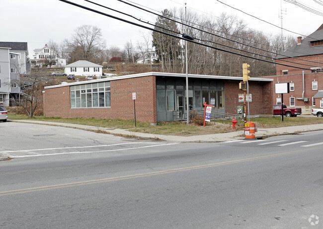
31 S Main St
Governmentalpublicusegeneral
Worcester
B
Massachusetts
B and X Area of moderate flood hazard, usually the area between the limits of the 100-year and 500-year floods.
0.77 AC
2025
Outlying Worcester
2025
Boston
749200
Worcester, MA
9,404 SF
UXBR-000250-000941
NEARBY LISTINGS FOR SALE OR LEASE
-
-
View all Uxbridge listings for sale on LoopNet.com
DEMOGRAPHICS near 31 S Main St
1 mile
3 mile
5 mile
2025 Total Population
5,044
17,424
42,182
2030 Population
5,200
18,004
43,434
Pop Growth 2025-2030
+ 3.09%
+ 3.33%
+ 2.97%
Average Age
42
43
42
2025 Total Households
2,013
6,864
16,123
HH Growth 2025-2030
+ 3.03%
+ 3.34%
+ 3.03%
Median Household Inc
$131,771
$118,154
$120,061
Avg Household Size
2.50
2.50
2.60
2025 Avg HH Vehicles
2.00
2.00
2.00
Median Home Value
$453,030
$452,627
$477,619
Median Year Built
1973
1981
1980
Nearby Places
Map Layers
Map Styles
 Street
 Aerial
Layers
 Traffic
 Biking
Places
Listings with unknown addresses are not visible on the map
- Restaurants
- Banks
- Shops
- Fitness
- Groceries
PUBLIC TRANSPORTATION
AIRPORT
Worcester Regional
Drive
Walk
Distance
Worcester Regional
37 min
23.6 mi
Rhode Island Tf Green International
Drive
Walk
Distance
Rhode Island Tf Green International
45 min
30.8 mi
Freight Ports
Port of Davisville, RI
Drive
Walk
Distance
Port of Davisville, RI
59 min
42.6 mi
Nearby Properties
Address
Land Use
TOTAL SIZE
Lot Size
Zoning
Address
Land Use
TOTAL SIZE
Lot Size
Zoning
450,800 SF
56.41 AC
I
Address
Land Use
TOTAL SIZE
Lot Size
Zoning
158,722 SF
77.55 AC
Address
Land Use
TOTAL SIZE
Lot Size
Zoning
173,667 SF
2.44 AC
Address
Land Use
TOTAL SIZE
Lot Size
Zoning
108.65 AC
RC
Address
Land Use
TOTAL SIZE
Lot Size
Zoning
192,817 SF
36.30 AC
RA
Address
Land Use
TOTAL SIZE
Lot Size
Zoning
48,071 SF
44.42 AC
I
Address
Land Use
TOTAL SIZE
Lot Size
Zoning
50.49 AC
Address
Land Use
TOTAL SIZE
Lot Size
Zoning
75,977 SF
12.90 AC
RB
Address
Land Use
TOTAL SIZE
Lot Size
Zoning
67,716 SF
42.39 AC
Address
Land Use
TOTAL SIZE
Lot Size
Zoning
119,200 SF
16.15 AC
I
Address
Land Use
TOTAL SIZE
Lot Size
Zoning
93,424 SF
6.90 AC
I
Address
Land Use
TOTAL SIZE
Lot Size
Zoning
28,468 SF
1.24 AC
I
Address
Land Use
TOTAL SIZE
Lot Size
Zoning
25,100 SF
7.40 AC
I
Address
Land Use
TOTAL SIZE
Lot Size
Zoning
41,071 SF
0.61 AC
RA
Address
Land Use
TOTAL SIZE
Lot Size
Zoning
25,601 SF
9.26 AC
RB
Address
Land Use
TOTAL SIZE
Lot Size
Zoning
2.72 AC
Address
Land Use
TOTAL SIZE
Lot Size
Zoning
28,170 SF
2.02 AC
RC
Address
Land Use
TOTAL SIZE
Lot Size
Zoning
28,875 SF
0.61 AC
Address
Land Use
TOTAL SIZE
Lot Size
Zoning
45,960 SF
2.88 AC
RA
Address
Land Use
TOTAL SIZE
Lot Size
Zoning
35,706 SF
2.87 AC
RB
Address
Land Use
TOTAL SIZE
Lot Size
Zoning
37,580 SF
14.10 AC
RB
Address
Land Use
TOTAL SIZE
Lot Size
Zoning
64,110 SF
6 AC
I
Address
Land Use
TOTAL SIZE
Lot Size
Zoning
70,000 SF
5.84 AC
I
Address
Land Use
TOTAL SIZE
Lot Size
Zoning
33,552 SF
7.87 AC
I
Address
Land Use
TOTAL SIZE
Lot Size
Zoning
7,176 SF
4.55 AC
I
Address
Land Use
TOTAL SIZE
Lot Size
Zoning
56.47 AC
RES
Address
Land Use
TOTAL SIZE
Lot Size
Zoning
25,702 SF
7.04 AC
AG
Address
Land Use
TOTAL SIZE
Lot Size
Zoning
117,586 SF
18.85 AC
B
Address
Land Use
TOTAL SIZE
Lot Size
Zoning
22,680 SF
29.31 AC
RC
Address
Land Use
TOTAL SIZE
Lot Size
Zoning
0.71 AC
The World's #1 Commercial Real Estate Marketplace
Connect with us
© 2026 CoStar Group
The information above has been obtained from sources believed reliable. While we do not doubt its accuracy we have not verified it and make no guarantee, warranty or representation about it. It is your responsibility to independently confirm its accuracy and completeness. Any projections, opinions, assumptions, or estimates used are for example only and do not represent the current or future performance of the property. The value of this transaction to you depends on tax and other factors which should be evaluated by your tax, financial, and legal advisors. You and your advisors should conduct a careful, independent investigation of the property to determine to your satisfaction the suitability of the property for your needs.