No Photo
Property Record
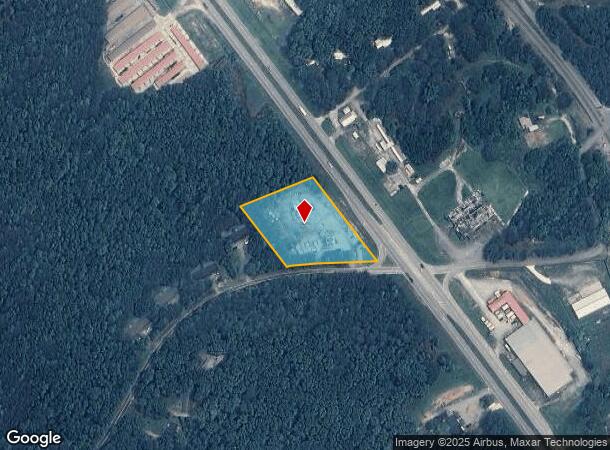
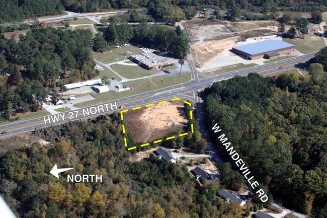
31 W Mandeville Rd, Carrollton, GA 30117

NEARBY LISTINGS FOR SALE OR LEASE
Property Detail
31 W Mandeville Rd
071-0219
Michael W Moon
Officebuilding
V/1.65AC HWY 27/W MANDEVILLE RD
X
Carroll
13143C0250B
Georgia
2025
1.65 AC
2025
W Carroll County
910301
Atlanta
240 SF
Atlanta-Sandy Springs-Roswell, GA
DEMOGRAPHICS near 31 W Mandeville Rd
1 Mile
3 Mile
5 Mile
2024 Total Population
834
5,122
22,073
2029 Population
938
5,778
24,682
Pop Growth 2024-2029
+ 12.47%
+ 12.81%
+ 11.82%
Average Age
37
38
37
2024 Total Households
307
1,811
7,828
HH Growth 2024-2029
+ 12.70%
+ 12.92%
+ 11.88%
Median Household Inc
$45,833
$49,775
$54,130
Avg Household Size
2.70
2.80
2.70
2024 Avg HH Vehicles
2.00
2.00
2.00
Median Home Value
$260,294
$216,667
$185,926
Median Year Built
1985
1990
1990
Nearby Places
Map Layers
Map Styles
 Street
 Aerial
- Restaurants
- Banks
- Shops
- Fitness
- Groceries
SALE & LEASE HISTORY
LISTING DATE
SALE/LEASE

Sep 24, 2016
For Sale
May 24, 2017
For Sale
Nearby Properties
Address
Land Use
TOTAL SIZE
Lot Size
Zoning
Address
Land Use
TOTAL SIZE
Lot Size
Zoning
932,068 SF
150.44 AC
I
Address
Land Use
TOTAL SIZE
Lot Size
Zoning
86,316 SF
12.85 AC
C2
Address
Land Use
TOTAL SIZE
Lot Size
Zoning
109,300 SF
127 AC
I
Address
Land Use
TOTAL SIZE
Lot Size
Zoning
22,780 SF
1.36 AC
C2
Address
Land Use
TOTAL SIZE
Lot Size
Zoning
39,500 SF
15.36 AC
OI
Address
Land Use
TOTAL SIZE
Lot Size
Zoning
28,186 SF
8 AC
C
Address
Land Use
TOTAL SIZE
Lot Size
Zoning
11,900 SF
2.48 AC
C
Address
Land Use
TOTAL SIZE
Lot Size
Zoning
29,600 SF
11.24 AC
001
Address
Land Use
TOTAL SIZE
Lot Size
Zoning
22,552 SF
3.74 AC
002
Address
Land Use
TOTAL SIZE
Lot Size
Zoning
51,408 SF
4.69 AC
C
Address
Land Use
TOTAL SIZE
Lot Size
Zoning
26,348 SF
5.50 AC
C
Address
Land Use
TOTAL SIZE
Lot Size
Zoning
8,130 SF
1.21 AC
C
Address
Land Use
TOTAL SIZE
Lot Size
Zoning
47,320 SF
17.84 AC
C
Address
Land Use
TOTAL SIZE
Lot Size
Zoning
9,804 SF
3.84 AC
C
Address
Land Use
TOTAL SIZE
Lot Size
Zoning
4,950 SF
1.76 AC
C2
Address
Land Use
TOTAL SIZE
Lot Size
Zoning
17.02 AC
002
Address
Land Use
TOTAL SIZE
Lot Size
Zoning
4,827 SF
1.60 AC
RESIDENTIA
Address
Land Use
TOTAL SIZE
Lot Size
Zoning
7,072 SF
36.89 AC
COMM
Address
Land Use
TOTAL SIZE
Lot Size
Zoning
4.56 AC
002
Address
Land Use
TOTAL SIZE
Lot Size
Zoning
15,000 SF
18.55 AC
C
Address
Land Use
TOTAL SIZE
Lot Size
Zoning
11,241 SF
2 AC
002
Address
Land Use
TOTAL SIZE
Lot Size
Zoning
20,100 SF
3.27 AC
C2
Address
Land Use
TOTAL SIZE
Lot Size
Zoning
13,278 SF
1.86 AC
C
Address
Land Use
TOTAL SIZE
Lot Size
Zoning
5,530 SF
1 AC
C
Address
Land Use
TOTAL SIZE
Lot Size
Zoning
4,680 SF
1.45 AC
002
Address
Land Use
TOTAL SIZE
Lot Size
Zoning
3,652 SF
1.17 AC
C2
Address
Land Use
TOTAL SIZE
Lot Size
Zoning
3,538 SF
1.04 AC
C
Address
Land Use
TOTAL SIZE
Lot Size
Zoning
9,230 SF
19.08 AC
A
Address
Land Use
TOTAL SIZE
Lot Size
Zoning
2,860 SF
1.08 AC
RESIDENTIA
Address
Land Use
TOTAL SIZE
Lot Size
Zoning
3,131 SF
1.20 AC
C2
The World's #1 Commercial Real Estate Marketplace
Connect with us
© 2025 CoStar Group
The information above has been obtained from sources believed reliable. While we do not doubt its accuracy we have not verified it and make no guarantee, warranty or representation about it. It is your responsibility to independently confirm its accuracy and completeness. Any projections, opinions, assumptions, or estimates used are for example only and do not represent the current or future performance of the property. The value of this transaction to you depends on tax and other factors which should be evaluated by your tax, financial, and legal advisors. You and your advisors should conduct a careful, independent investigation of the property to determine to your satisfaction the suitability of the property for your needs.