Property Record
31 Wells Rd, Granby, CT 06035
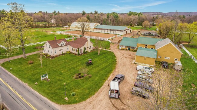

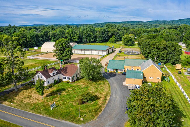
Property Detail
31 Wells Rd
GRAN-000043E-000042-000017
Capitol
Commercialnec
Connecticut
R30
17
B and X Area of moderate flood hazard, usually the area between the limits of the 100-year and 500-year floods.
7.48 AC
2025
Northwest Outlying
2025
Hartford
468101
Hartford-West Hartford-East Hartford, CT
2,519 SF
NEARBY LISTINGS FOR SALE OR LEASE
-
-
View all Granby listings for sale on LoopNet.com
DEMOGRAPHICS near 31 Wells Rd
1 mile
3 mile
5 mile
2025 Total Population
1,886
8,822
22,843
2030 Population
1,910
9,044
23,385
Pop Growth 2025-2030
+ 1.27%
+ 2.52%
+ 2.37%
Average Age
43
44
43
2025 Total Households
719
3,416
8,972
HH Growth 2025-2030
+ 1.25%
+ 2.58%
+ 2.41%
Median Household Inc
$155,030
$121,144
$123,171
Avg Household Size
2.60
2.50
2.50
2025 Avg HH Vehicles
3.00
2.00
2.00
Median Home Value
$397,926
$393,429
$406,700
Median Year Built
1971
1975
1976
Nearby Places
Map Layers
Map Styles
 Street
 Aerial
Layers
 Traffic
 Biking
Places
Listings with unknown addresses are not visible on the map
- Restaurants
- Banks
- Shops
- Fitness
- Groceries
PUBLIC TRANSPORTATION
AIRPORT
Bradley International
Drive
Walk
Distance
Bradley International
25 min
9.2 mi
Freight Ports
Port of New Haven
Drive
Walk
Distance
Port of New Haven
77 min
52.7 mi
SALE & LEASE HISTORY
LISTING DATE
SALE/LEASE

Sep 14, 2019
For Sale
Jan 05, 2018
For Sale
Nearby Properties
Address
Land Use
TOTAL SIZE
Lot Size
Zoning
Address
Land Use
TOTAL SIZE
Lot Size
Zoning
1,517 SF
45.69 AC
CC
Address
Land Use
TOTAL SIZE
Lot Size
Zoning
27.95 AC
CC
Address
Land Use
TOTAL SIZE
Lot Size
Zoning
58,477 SF
14.99 AC
R30
Address
Land Use
TOTAL SIZE
Lot Size
Zoning
61,692 SF
12 AC
R50
Address
Land Use
TOTAL SIZE
Lot Size
Zoning
13.05 AC
C2
Address
Land Use
TOTAL SIZE
Lot Size
Zoning
14.38 AC
CC
Address
Land Use
TOTAL SIZE
Lot Size
Zoning
5.96 AC
CO
Address
Land Use
TOTAL SIZE
Lot Size
Zoning
54,568 SF
11.74 AC
C2
Address
Land Use
TOTAL SIZE
Lot Size
Zoning
7.40 AC
CE
Address
Land Use
TOTAL SIZE
Lot Size
Zoning
43,094 SF
33.80 AC
R30
Address
Land Use
TOTAL SIZE
Lot Size
Zoning
1,064.60 AC
R2A
Address
Land Use
TOTAL SIZE
Lot Size
Zoning
12.98 AC
I
Address
Land Use
TOTAL SIZE
Lot Size
Zoning
12.98 AC
Address
Land Use
TOTAL SIZE
Lot Size
Zoning
2.70 AC
CO
Address
Land Use
TOTAL SIZE
Lot Size
Zoning
22.23 AC
R2A
Address
Land Use
TOTAL SIZE
Lot Size
Zoning
16,543 SF
1.91 AC
R50
Address
Land Use
TOTAL SIZE
Lot Size
Zoning
10,107 SF
1.40 AC
CO
Address
Land Use
TOTAL SIZE
Lot Size
Zoning
2.89 AC
R30
Address
Land Use
TOTAL SIZE
Lot Size
Zoning
13,991 SF
2.08 AC
R30
Address
Land Use
TOTAL SIZE
Lot Size
Zoning
4.20 AC
CC
Address
Land Use
TOTAL SIZE
Lot Size
Zoning
13,243 SF
3.08 AC
CC
Address
Land Use
TOTAL SIZE
Lot Size
Zoning
5.16 AC
I
Address
Land Use
TOTAL SIZE
Lot Size
Zoning
5,568 SF
5.51 AC
R-40
Address
Land Use
TOTAL SIZE
Lot Size
Zoning
5.98 AC
CE
Address
Land Use
TOTAL SIZE
Lot Size
Zoning
5,000 SF
3.36 AC
I
Address
Land Use
TOTAL SIZE
Lot Size
Zoning
4.30 AC
C2
Address
Land Use
TOTAL SIZE
Lot Size
Zoning
5.74 AC
CC
Address
Land Use
TOTAL SIZE
Lot Size
Zoning
3,370 SF
72.03 AC
R50
Address
Land Use
TOTAL SIZE
Lot Size
Zoning
4,485 SF
2.02 AC
CO
Address
Land Use
TOTAL SIZE
Lot Size
Zoning
3.88 AC
I
The World's #1 Commercial Real Estate Marketplace
Connect with us
© 2026 CoStar Group
The information above has been obtained from sources believed reliable. While we do not doubt its accuracy we have not verified it and make no guarantee, warranty or representation about it. It is your responsibility to independently confirm its accuracy and completeness. Any projections, opinions, assumptions, or estimates used are for example only and do not represent the current or future performance of the property. The value of this transaction to you depends on tax and other factors which should be evaluated by your tax, financial, and legal advisors. You and your advisors should conduct a careful, independent investigation of the property to determine to your satisfaction the suitability of the property for your needs.