Property Record
310 Greystone Blvd, Columbia, SC 29210
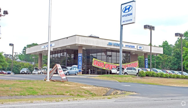

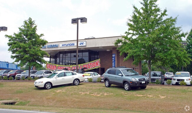
Property Detail
310 Greystone Blvd
07309-03-08
PROPOSED PARCEL 1 442.1X30.8X103.4X39.1X427.1X 218.5X4.8X43.8X176.4X89.9X ETC #SU
Commercialnec
Richland
GC
South Carolina
B and X Area of moderate flood hazard, usually the area between the limits of the 100-year and 500-year floods.
6.49 AC
2025
St Andrews
2025
Columbia
010403
Columbia, SC
13,879 SF
NEARBY LISTINGS FOR SALE OR LEASE
DEMOGRAPHICS near 310 Greystone Blvd
1 mile
3 mile
5 mile
2025 Total Population
6,003
66,220
168,472
2030 Population
6,249
68,864
175,708
Pop Growth 2025-2030
+ 4.10%
+ 3.99%
+ 4.30%
Average Age
35
37
37
2025 Total Households
3,163
30,930
73,277
HH Growth 2025-2030
+ 4.11%
+ 4.13%
+ 4.67%
Median Household Inc
$55,387
$51,370
$50,943
Avg Household Size
1.90
2.00
2.00
2025 Avg HH Vehicles
1.00
1.00
2.00
Median Home Value
$199,457
$206,466
$213,590
Median Year Built
1981
1975
1973
Nearby Places
Map Layers
Map Styles
 Street
 Aerial
Layers
 Traffic
 Biking
Places
Listings with unknown addresses are not visible on the map
- Restaurants
- Banks
- Shops
- Fitness
- Groceries
PUBLIC TRANSPORTATION
COMMUTER RAIL
Columbia Amtrak Station (Silver Star - Amtrak)
Drive
Walk
Distance
Columbia Amtrak Station (Silver Star - Amtrak)
6 min
3.3 mi
AIRPORT
Columbia Metro
Drive
Walk
Distance
Columbia Metro
22 min
11.4 mi
Freight Ports
North Charleston Terminal
Drive
Walk
Distance
North Charleston Terminal
122 min
107.7 mi
Nearby Properties
Address
Land Use
TOTAL SIZE
Lot Size
Zoning
Address
Land Use
TOTAL SIZE
Lot Size
Zoning
106,284 SF
10.83 AC
C-5
Address
Land Use
TOTAL SIZE
Lot Size
Zoning
456,218 SF
1 AC
DAC
Address
Land Use
TOTAL SIZE
Lot Size
Zoning
413,000 SF
3.48 AC
MC
Address
Land Use
TOTAL SIZE
Lot Size
Zoning
160,510 SF
0.26 AC
DAC
Address
Land Use
TOTAL SIZE
Lot Size
Zoning
311,754 SF
1.78 AC
DAC
Address
Land Use
TOTAL SIZE
Lot Size
Zoning
375,417 SF
3.92 AC
INS-GEN
Address
Land Use
TOTAL SIZE
Lot Size
Zoning
2.07 AC
DAC
Address
Land Use
TOTAL SIZE
Lot Size
Zoning
204,154 SF
1.37 AC
DAC
Address
Land Use
TOTAL SIZE
Lot Size
Zoning
530,349 SF
0.75 AC
DAC
Address
Land Use
TOTAL SIZE
Lot Size
Zoning
119,738 SF
10.30 AC
EC
Address
Land Use
TOTAL SIZE
Lot Size
Zoning
100 SF
9.81 AC
MC
Address
Land Use
TOTAL SIZE
Lot Size
Zoning
353,447 SF
0.53 AC
DAC
Address
Land Use
TOTAL SIZE
Lot Size
Zoning
128,160 SF
9.31 AC
RM-HD
Address
Land Use
TOTAL SIZE
Lot Size
Zoning
311,168 SF
3.98 AC
MC
Address
Land Use
TOTAL SIZE
Lot Size
Zoning
494,384 SF
1.67 AC
MC
Address
Land Use
TOTAL SIZE
Lot Size
Zoning
358,561 SF
42.10 AC
EC
Address
Land Use
TOTAL SIZE
Lot Size
Zoning
291,996 SF
0.78 AC
DAC
Address
Land Use
TOTAL SIZE
Lot Size
Zoning
354,235 SF
0.80 AC
DAC
Address
Land Use
TOTAL SIZE
Lot Size
Zoning
163,868 SF
4.35 AC
CAC
Address
Land Use
TOTAL SIZE
Lot Size
Zoning
90,588 SF
3.72 AC
DAC
Address
Land Use
TOTAL SIZE
Lot Size
Zoning
85,065 SF
2.43 AC
C-1
Address
Land Use
TOTAL SIZE
Lot Size
Zoning
128,877 SF
24.71 AC
RM-HD
Address
Land Use
TOTAL SIZE
Lot Size
Zoning
221,186 SF
1.31 AC
DAC
Address
Land Use
TOTAL SIZE
Lot Size
Zoning
319,842 SF
0.78 AC
DAC
Address
Land Use
TOTAL SIZE
Lot Size
Zoning
65,000 SF
4.75 AC
C-1
Address
Land Use
TOTAL SIZE
Lot Size
Zoning
315,000 SF
1.38 AC
C-5
Address
Land Use
TOTAL SIZE
Lot Size
Zoning
183,392 SF
14.77 AC
RM-HD
Address
Land Use
TOTAL SIZE
Lot Size
Zoning
100 SF
4.24 AC
INS-GEN
Address
Land Use
TOTAL SIZE
Lot Size
Zoning
352,672 SF
5.16 AC
MC
Address
Land Use
TOTAL SIZE
Lot Size
Zoning
66,720 SF
19.20 AC
RM-2
The World's #1 Commercial Real Estate Marketplace
Connect with us
© 2026 CoStar Group
The information above has been obtained from sources believed reliable. While we do not doubt its accuracy we have not verified it and make no guarantee, warranty or representation about it. It is your responsibility to independently confirm its accuracy and completeness. Any projections, opinions, assumptions, or estimates used are for example only and do not represent the current or future performance of the property. The value of this transaction to you depends on tax and other factors which should be evaluated by your tax, financial, and legal advisors. You and your advisors should conduct a careful, independent investigation of the property to determine to your satisfaction the suitability of the property for your needs.