Property Record
310 N 78Th St, Seattle, WA 98103

Save to a Folder
{{folder.Name}}
{{folder.ListingIds.length}} Properties
{{folder.ListingIds.length}} Property
Create a New Folder
Property Detail
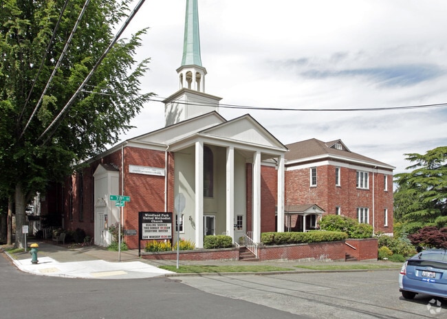
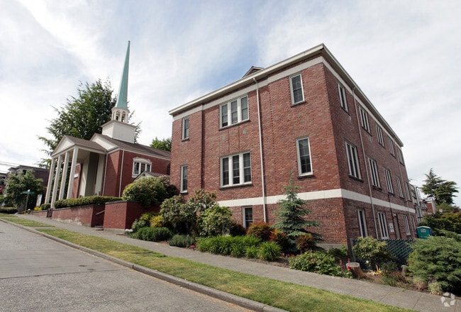
310 N 78Th St
009100-0085
ALBERT ADD
Religious
KING
NC2-55 (M)
Washington
B and X Area of moderate flood hazard, usually the area between the limits of the 100-year and 500-year floods.
1-2-3
0
0.46 AC
2025
Ballard/U Dist
002800
Seattle/Puget Sound
21,022 SF
Seattle-Tacoma-Bellevue, WA
NEARBY LISTINGS FOR SALE OR LEASE
DEMOGRAPHICS near 310 N 78Th St
1 mile
3 mile
5 mile
2025 Total Population
35,123
271,240
503,824
2030 Population
36,629
283,632
527,339
Pop Growth 2025-2030
+ 4.29%
+ 4.57%
+ 4.67%
Average Age
39
37
38
2025 Total Households
15,535
122,103
240,549
HH Growth 2025-2030
+ 4.36%
+ 4.88%
+ 4.96%
Median Household Inc
$147,115
$122,017
$125,843
Avg Household Size
2.20
2.00
2.00
2025 Avg HH Vehicles
2.00
1.00
1.00
Median Home Value
$990,445
$997,881
$1,004,752
Median Year Built
1956
1974
1977
Nearby Places
Map Layers
Map Styles
 Street
 Aerial
Layers
 Traffic
 Biking
Places
Listings with unknown addresses are not visible on the map
- Restaurants
- Banks
- Shops
- Fitness
- Groceries
PUBLIC TRANSPORTATION
COMMUTER RAIL
King Street (Seattle) Station (Sounder South Line - Central Puget Sound Regional Transit Authority Rail (Link Light Rail/Sounder))
Drive
Walk
Distance
King Street (Seattle) Station (Sounder South Line - Central Puget Sound Regional Transit Authority Rail (Link Light Rail/Sounder))
16 min
8.4 mi
AIRPORT
Seattle Paine Field International
Drive
Walk
Distance
Seattle Paine Field International
31 min
19.3 mi
Seattle-Tacoma International
Drive
Walk
Distance
Seattle-Tacoma International
35 min
21.6 mi
Freight Ports
Port of Seattle
Drive
Walk
Distance
Port of Seattle
21 min
9.6 mi
Nearby Properties
Address
Land Use
TOTAL SIZE
Lot Size
Zoning
Address
Land Use
TOTAL SIZE
Lot Size
Zoning
7,549 SF
59.34 AC
MIO-105-LR
Address
Land Use
TOTAL SIZE
Lot Size
Zoning
612,844 SF
0.09 AC
SM-U/R 75-
Address
Land Use
TOTAL SIZE
Lot Size
Zoning
107.93 AC
NR3
Address
Land Use
TOTAL SIZE
Lot Size
Zoning
42,500 SF
90.92 AC
NR3
Address
Land Use
TOTAL SIZE
Lot Size
Zoning
241,955 SF
12.81 AC
LR2 (M)
Address
Land Use
TOTAL SIZE
Lot Size
Zoning
12,544 SF
99.44 AC
C1-40
Address
Land Use
TOTAL SIZE
Lot Size
Zoning
20,289 SF
10.76 AC
MIO-50-LR3
Address
Land Use
TOTAL SIZE
Lot Size
Zoning
79,572 SF
27.40 AC
MML U/45
Address
Land Use
TOTAL SIZE
Lot Size
Zoning
0.31 AC
SM-U 95-32
Address
Land Use
TOTAL SIZE
Lot Size
Zoning
227,088 SF
1.64 AC
NC3-75 (M)
Address
Land Use
TOTAL SIZE
Lot Size
Zoning
65,643 SF
53.62 AC
MML U/45
Address
Land Use
TOTAL SIZE
Lot Size
Zoning
0.46 AC
SM-U 95-32
Address
Land Use
TOTAL SIZE
Lot Size
Zoning
6.87 AC
MIO-200-C1
Address
Land Use
TOTAL SIZE
Lot Size
Zoning
285,140 SF
0.90 AC
NC2-75 (M1
Address
Land Use
TOTAL SIZE
Lot Size
Zoning
210,103 SF
1.03 AC
NC3P-95 (M
Address
Land Use
TOTAL SIZE
Lot Size
Zoning
25,735 SF
1.56 AC
C1-75 (M)
Address
Land Use
TOTAL SIZE
Lot Size
Zoning
223,047 SF
0.18 AC
NC2P-75 (M
Address
Land Use
TOTAL SIZE
Lot Size
Zoning
131,790 SF
0.37 AC
SM-U 75-24
Address
Land Use
TOTAL SIZE
Lot Size
Zoning
6,534 SF
0.55 AC
IC-65 (M)
Address
Land Use
TOTAL SIZE
Lot Size
Zoning
172,297 SF
4.21 AC
NC3-95 (M)
Address
Land Use
TOTAL SIZE
Lot Size
Zoning
10,090 SF
11.73 AC
NC3-95 (M)
Address
Land Use
TOTAL SIZE
Lot Size
Zoning
1,100 SF
18.83 AC
UI U/45
Address
Land Use
TOTAL SIZE
Lot Size
Zoning
189,475 SF
1.15 AC
NC3P-75 (M
Address
Land Use
TOTAL SIZE
Lot Size
Zoning
382,762 SF
7.14 AC
NR3
Address
Land Use
TOTAL SIZE
Lot Size
Zoning
199,018 SF
0.40 AC
NC3P-95 (M
Address
Land Use
TOTAL SIZE
Lot Size
Zoning
215,468 SF
0.60 AC
NC2-75 (M1
Address
Land Use
TOTAL SIZE
Lot Size
Zoning
162,182 SF
9.10 AC
LR2 (M)
Address
Land Use
TOTAL SIZE
Lot Size
Zoning
132,183 SF
0.76 AC
NC2-65
Address
Land Use
TOTAL SIZE
Lot Size
Zoning
196,820 SF
0.64 AC
NC3P-95 (M
The World's #1 Commercial Real Estate Marketplace
Connect with us
© 2026 CoStar Group
The information above has been obtained from sources believed reliable. While we do not doubt its accuracy we have not verified it and make no guarantee, warranty or representation about it. It is your responsibility to independently confirm its accuracy and completeness. Any projections, opinions, assumptions, or estimates used are for example only and do not represent the current or future performance of the property. The value of this transaction to you depends on tax and other factors which should be evaluated by your tax, financial, and legal advisors. You and your advisors should conduct a careful, independent investigation of the property to determine to your satisfaction the suitability of the property for your needs.