Property Record
310 N College Rd, Wilmington, NC 28405
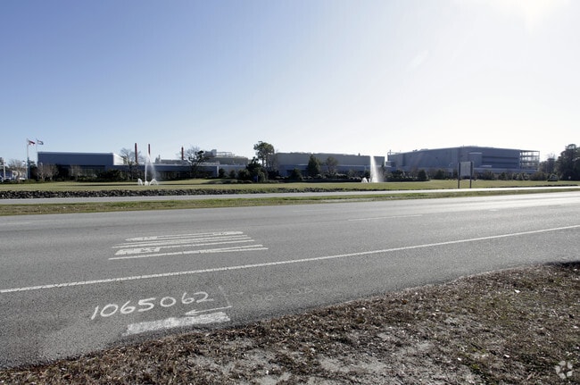

Property Detail
310 N College Rd
R04900-002-001-00A
EXEMPT REAL EST OF C GLASS
Factorymedium
NEW HANOVER
IND
North Carolina
AE The base floodplain where base flood elevations are provided. AE Zones are now used on new format FIRMs instead of A1-A30 Zones.
1
0
Market Street Corridor
2025
Wilmington
011606
Wilmington, NC
NEARBY LISTINGS FOR SALE OR LEASE
DEMOGRAPHICS near 310 N College Rd
1 mile
3 mile
5 mile
2025 Total Population
5,846
64,699
140,150
2030 Population
6,104
68,059
147,858
Pop Growth 2025-2030
+ 4.41%
+ 5.19%
+ 5.50%
Average Age
38
37
40
2025 Total Households
2,626
27,752
60,640
HH Growth 2025-2030
+ 4.53%
+ 5.52%
+ 5.72%
Median Household Inc
$73,973
$64,338
$73,277
Avg Household Size
2.20
2.10
2.20
2025 Avg HH Vehicles
2.00
2.00
2.00
Median Home Value
$311,279
$346,195
$373,803
Median Year Built
1987
1992
1990
Nearby Places
Map Layers
Map Styles
 Street
 Aerial
Transit
 Traffic
 Biking
Places
Listings with unknown addresses are not visible on the map
- Restaurants
- Banks
- Shops
- Fitness
- Groceries
PUBLIC TRANSPORTATION
AIRPORT
Wilmington International
Drive
Walk
Distance
Wilmington International
14 min
6.5 mi
Freight Ports
Port of Wilmington
Drive
Walk
Distance
Port of Wilmington
15 min
8.1 mi
Nearby Properties
Address
Land Use
TOTAL SIZE
Lot Size
Zoning
Address
Land Use
TOTAL SIZE
Lot Size
Zoning
18,848 SF
649.08 AC
O&I,OFFICE
Address
Land Use
TOTAL SIZE
Lot Size
Zoning
13,398 SF
15.67 AC
O&I,OFFICE
Address
Land Use
TOTAL SIZE
Lot Size
Zoning
35,600 SF
14.86 AC
CB,COMMUNI
Address
Land Use
TOTAL SIZE
Lot Size
Zoning
11,500 SF
1,340.44 AC
AC
Address
Land Use
TOTAL SIZE
Lot Size
Zoning
12,336 SF
67.48 AC
IND
Address
Land Use
TOTAL SIZE
Lot Size
Zoning
194,040 SF
7.74 AC
MX
Address
Land Use
TOTAL SIZE
Lot Size
Zoning
5,563 SF
13.60 AC
MD-17
Address
Land Use
TOTAL SIZE
Lot Size
Zoning
93,946 SF
AC
Address
Land Use
TOTAL SIZE
Lot Size
Zoning
191,720 SF
7.82 AC
RB,REGIONA
Address
Land Use
TOTAL SIZE
Lot Size
Zoning
142,207 SF
9.29 AC
O&I,OFFICE
Address
Land Use
TOTAL SIZE
Lot Size
Zoning
3,540 SF
25.10 AC
MX
Address
Land Use
TOTAL SIZE
Lot Size
Zoning
186,960 SF
8.80 AC
O&I,OFFICE
Address
Land Use
TOTAL SIZE
Lot Size
Zoning
150,588 SF
30.57 AC
RB,REGIONA
Address
Land Use
TOTAL SIZE
Lot Size
Zoning
128,015 SF
6.91 AC
RB,REGIONA
Address
Land Use
TOTAL SIZE
Lot Size
Zoning
153,764 SF
22.87 AC
RB,REGIONA
Address
Land Use
TOTAL SIZE
Lot Size
Zoning
6,780 SF
24.11 AC
RB,REGIONA
Address
Land Use
TOTAL SIZE
Lot Size
Zoning
116,691 SF
14.43 AC
RB,REGIONA
Address
Land Use
TOTAL SIZE
Lot Size
Zoning
41,145 SF
13.58 AC
CB,COMMUNI
Address
Land Use
TOTAL SIZE
Lot Size
Zoning
290,417 SF
15.78 AC
AI,AIRPORT
Address
Land Use
TOTAL SIZE
Lot Size
Zoning
101,003 SF
7.89 AC
MX
Address
Land Use
TOTAL SIZE
Lot Size
Zoning
115,283 SF
4.45 AC
RB,REGIONA
Address
Land Use
TOTAL SIZE
Lot Size
Zoning
70,842 SF
4.91 AC
AI,AIRPORT
Address
Land Use
TOTAL SIZE
Lot Size
Zoning
94,518 SF
13.73 AC
O&I,OFFICE
Address
Land Use
TOTAL SIZE
Lot Size
Zoning
4,428 SF
4.47 AC
O&I,OFFICE
Address
Land Use
TOTAL SIZE
Lot Size
Zoning
27,108 SF
31.84 AC
AI,AIRPORT
Address
Land Use
TOTAL SIZE
Lot Size
Zoning
73,457 SF
6.77 AC
MX
Address
Land Use
TOTAL SIZE
Lot Size
Zoning
30,595 SF
4.12 AC
O&I,OFFICE
Address
Land Use
TOTAL SIZE
Lot Size
Zoning
212,000 SF
13.18 AC
AI,AIRPORT
Address
Land Use
TOTAL SIZE
Lot Size
Zoning
66,622 SF
3.28 AC
MX
The World's #1 Commercial Real Estate Marketplace
Connect with us
© 2026 CoStar Group
The information above has been obtained from sources believed reliable. While we do not doubt its accuracy we have not verified it and make no guarantee, warranty or representation about it. It is your responsibility to independently confirm its accuracy and completeness. Any projections, opinions, assumptions, or estimates used are for example only and do not represent the current or future performance of the property. The value of this transaction to you depends on tax and other factors which should be evaluated by your tax, financial, and legal advisors. You and your advisors should conduct a careful, independent investigation of the property to determine to your satisfaction the suitability of the property for your needs.