Property Record
310 S 9Th St, Philomath, OR 97370

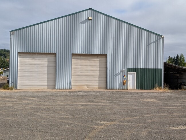
This Property Is For Sale
Property Detail
310 S 9Th St
388584
LOT 3
Industrialgeneral
BENTON
IL
Oregon
AE The base floodplain where base flood elevations are provided. AE Zones are now used on new format FIRMs instead of A1-A30 Zones.
3
2024
4.54 AC
2025
Oregon West Area
010800
Other Market Areas
6,192 SF
Corvallis, OR
NEARBY LISTINGS FOR SALE OR LEASE
DEMOGRAPHICS near 310 S 9Th St
1 mile
3 mile
5 mile
2025 Total Population
3,565
8,939
23,369
2030 Population
3,628
9,115
23,856
Pop Growth 2025-2030
+ 1.77%
+ 1.97%
+ 2.08%
Average Age
42
43
42
2025 Total Households
1,384
3,557
9,687
HH Growth 2025-2030
+ 1.81%
+ 1.97%
+ 2.10%
Median Household Inc
$80,662
$89,536
$89,262
Avg Household Size
2.50
2.50
2.40
2025 Avg HH Vehicles
2.00
2.00
2.00
Median Home Value
$423,979
$495,454
$605,085
Median Year Built
1977
1984
1987
Nearby Places
Map Layers
Map Styles
 Street
 Aerial
Transit
 Traffic
 Biking
Places
Listings with unknown addresses are not visible on the map
- Restaurants
- Banks
- Shops
- Fitness
- Groceries
PUBLIC TRANSPORTATION
AIRPORT
Mahlon Sweet Field
Drive
Walk
Distance
Mahlon Sweet Field
64 min
39.1 mi
Freight Ports
Port of Portland
Drive
Walk
Distance
Port of Portland
121 min
92.5 mi
Nearby Properties
Address
Land Use
TOTAL SIZE
Lot Size
Zoning
Address
Land Use
TOTAL SIZE
Lot Size
Zoning
241,599 SF
14.33 AC
R-3
Address
Land Use
TOTAL SIZE
Lot Size
Zoning
124,682 SF
10.62 AC
PD(RS-12)
Address
Land Use
TOTAL SIZE
Lot Size
Zoning
15.04 AC
RI
Address
Land Use
TOTAL SIZE
Lot Size
Zoning
38,420 SF
5.43 AC
LDR
Address
Land Use
TOTAL SIZE
Lot Size
Zoning
Address
Land Use
TOTAL SIZE
Lot Size
Zoning
64,359 SF
5.85 AC
PF
Address
Land Use
TOTAL SIZE
Lot Size
Zoning
Address
Land Use
TOTAL SIZE
Lot Size
Zoning
151,683 SF
17.22 AC
IO
Address
Land Use
TOTAL SIZE
Lot Size
Zoning
Address
Land Use
TOTAL SIZE
Lot Size
Zoning
15,549 SF
3.93 AC
PF
Address
Land Use
TOTAL SIZE
Lot Size
Zoning
75,776 SF
3.18 AC
MURM
Address
Land Use
TOTAL SIZE
Lot Size
Zoning
14,688 SF
1.57 AC
PF
Address
Land Use
TOTAL SIZE
Lot Size
Zoning
40,239 SF
2.51 AC
RS-20
Address
Land Use
TOTAL SIZE
Lot Size
Zoning
Address
Land Use
TOTAL SIZE
Lot Size
Zoning
Address
Land Use
TOTAL SIZE
Lot Size
Zoning
9,640 SF
33.12 AC
P
Address
Land Use
TOTAL SIZE
Lot Size
Zoning
18,536 SF
2.65 AC
MURM
Address
Land Use
TOTAL SIZE
Lot Size
Zoning
16,496 SF
2.80 AC
LDR
Address
Land Use
TOTAL SIZE
Lot Size
Zoning
Address
Land Use
TOTAL SIZE
Lot Size
Zoning
1 SF
27.73 AC
IH
Address
Land Use
TOTAL SIZE
Lot Size
Zoning
15,484 SF
2.75 AC
PF
Address
Land Use
TOTAL SIZE
Lot Size
Zoning
Address
Land Use
TOTAL SIZE
Lot Size
Zoning
21,480 SF
36.19 AC
IO
Address
Land Use
TOTAL SIZE
Lot Size
Zoning
1 SF
19.64 AC
UI
Address
Land Use
TOTAL SIZE
Lot Size
Zoning
Address
Land Use
TOTAL SIZE
Lot Size
Zoning
1,036 SF
10.56 AC
PF
Address
Land Use
TOTAL SIZE
Lot Size
Zoning
22.90 AC
RI
Address
Land Use
TOTAL SIZE
Lot Size
Zoning
20,578 SF
1.52 AC
CG
Address
Land Use
TOTAL SIZE
Lot Size
Zoning
Address
Land Use
TOTAL SIZE
Lot Size
Zoning
20,000 SF
7.16 AC
IL
The World's #1 Commercial Real Estate Marketplace
Connect with us
© 2026 CoStar Group
The information above has been obtained from sources believed reliable. While we do not doubt its accuracy we have not verified it and make no guarantee, warranty or representation about it. It is your responsibility to independently confirm its accuracy and completeness. Any projections, opinions, assumptions, or estimates used are for example only and do not represent the current or future performance of the property. The value of this transaction to you depends on tax and other factors which should be evaluated by your tax, financial, and legal advisors. You and your advisors should conduct a careful, independent investigation of the property to determine to your satisfaction the suitability of the property for your needs.