Property Record
310 S Coltrane Rd, Edmond, OK 73034
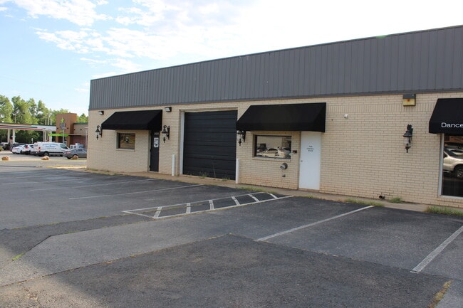

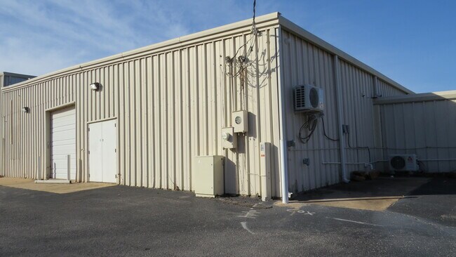

Property Detail
310 S Coltrane Rd
189253590
UNPLTD PT NW4 SEC 32 14N 2W BEG 330FT S OF NW/C NW4 TH E550FT S440FT W550FT N440FT TO BEG SUBJ TO ESMTS OF RECORD
Lightindustrial
OKLAHOMA
AE The base floodplain where base flood elevations are provided. AE Zones are now used on new format FIRMs instead of A1-A30 Zones.
Oklahoma
2024
5.05 AC
2025
Edmond
108106
Oklahoma City
16,520 SF
Oklahoma City, OK
NEARBY LISTINGS FOR SALE OR LEASE
DEMOGRAPHICS near 310 S Coltrane Rd
1 mile
3 mile
5 mile
2025 Total Population
8,721
51,627
105,851
2030 Population
8,792
52,373
107,476
Pop Growth 2025-2030
+ 0.81%
+ 1.44%
+ 1.54%
Average Age
37
39
39
2025 Total Households
3,692
20,605
40,803
HH Growth 2025-2030
+ 1.03%
+ 1.58%
+ 1.61%
Median Household Inc
$99,562
$94,337
$103,488
Avg Household Size
2.30
2.40
2.50
2025 Avg HH Vehicles
2.00
2.00
2.00
Median Home Value
$384,471
$352,849
$347,405
Median Year Built
1993
1986
1992
Nearby Places
Map Layers
Map Styles
 Street
 Aerial
Layers
 Traffic
 Biking
Places
Listings with unknown addresses are not visible on the map
- Restaurants
- Banks
- Shops
- Fitness
- Groceries
PUBLIC TRANSPORTATION
AIRPORT
Will Rogers World
Drive
Walk
Distance
Will Rogers World
35 min
26.5 mi
SALE & LEASE HISTORY
LISTING DATE
SALE/LEASE

Sep 08, 2021
For Sale
Jan 22, 2025
For Lease
Nearby Properties
Address
Land Use
TOTAL SIZE
Lot Size
Zoning
Address
Land Use
TOTAL SIZE
Lot Size
Zoning
200,545 SF
24.93 AC
Address
Land Use
TOTAL SIZE
Lot Size
Zoning
280,581 SF
28.90 AC
Address
Land Use
TOTAL SIZE
Lot Size
Zoning
304,744 SF
21.61 AC
Address
Land Use
TOTAL SIZE
Lot Size
Zoning
371,968 SF
30.50 AC
Address
Land Use
TOTAL SIZE
Lot Size
Zoning
32.33 AC
Address
Land Use
TOTAL SIZE
Lot Size
Zoning
402,880 SF
15.39 AC
Address
Land Use
TOTAL SIZE
Lot Size
Zoning
164,940 SF
27.04 AC
Address
Land Use
TOTAL SIZE
Lot Size
Zoning
265,194 SF
13.67 AC
Address
Land Use
TOTAL SIZE
Lot Size
Zoning
147,080 SF
10.38 AC
Address
Land Use
TOTAL SIZE
Lot Size
Zoning
99,783 SF
16.78 AC
Address
Land Use
TOTAL SIZE
Lot Size
Zoning
8,976 SF
1.14 AC
Address
Land Use
TOTAL SIZE
Lot Size
Zoning
6,636 SF
0.18 AC
Address
Land Use
TOTAL SIZE
Lot Size
Zoning
10,193 SF
0.81 AC
Address
Land Use
TOTAL SIZE
Lot Size
Zoning
132,226 SF
11.89 AC
Address
Land Use
TOTAL SIZE
Lot Size
Zoning
64,296 SF
8.43 AC
Address
Land Use
TOTAL SIZE
Lot Size
Zoning
72,273 SF
6.58 AC
Address
Land Use
TOTAL SIZE
Lot Size
Zoning
176,307 SF
14.76 AC
Address
Land Use
TOTAL SIZE
Lot Size
Zoning
8,760 SF
1.05 AC
Address
Land Use
TOTAL SIZE
Lot Size
Zoning
197,818 SF
28.97 AC
Address
Land Use
TOTAL SIZE
Lot Size
Zoning
28,150 SF
4.81 AC
Address
Land Use
TOTAL SIZE
Lot Size
Zoning
140,928 SF
9.60 AC
Address
Land Use
TOTAL SIZE
Lot Size
Zoning
159,232 SF
14.06 AC
Address
Land Use
TOTAL SIZE
Lot Size
Zoning
134,995 SF
15.99 AC
Address
Land Use
TOTAL SIZE
Lot Size
Zoning
57,592 SF
8.96 AC
Address
Land Use
TOTAL SIZE
Lot Size
Zoning
66,514 SF
2.67 AC
Address
Land Use
TOTAL SIZE
Lot Size
Zoning
110,250 SF
10 AC
Address
Land Use
TOTAL SIZE
Lot Size
Zoning
1,360 SF
22.18 AC
Address
Land Use
TOTAL SIZE
Lot Size
Zoning
90,991 SF
18.36 AC
Address
Land Use
TOTAL SIZE
Lot Size
Zoning
152,604 SF
7.10 AC
The World's #1 Commercial Real Estate Marketplace
Connect with us
© 2026 CoStar Group
The information above has been obtained from sources believed reliable. While we do not doubt its accuracy we have not verified it and make no guarantee, warranty or representation about it. It is your responsibility to independently confirm its accuracy and completeness. Any projections, opinions, assumptions, or estimates used are for example only and do not represent the current or future performance of the property. The value of this transaction to you depends on tax and other factors which should be evaluated by your tax, financial, and legal advisors. You and your advisors should conduct a careful, independent investigation of the property to determine to your satisfaction the suitability of the property for your needs.