Property Record
310 Taryn Ave, Raleigh, NC 27603
NEARBY LISTINGS FOR SALE OR LEASE
-
-
View all Raleigh listings for sale on LoopNet.com
Property Detail
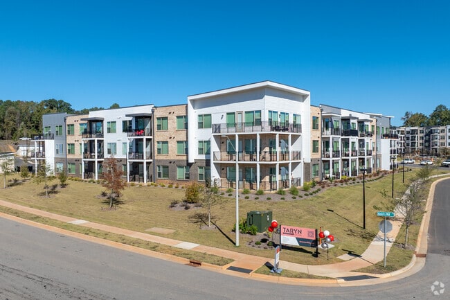
310 Taryn Ave
Raleigh-Cary, NC
Apartment Phase I Llc
0790.03-31-0360-000
401 APARTMENT PHASE I LLC UNRCD SRVY
Apartment
Wake
2025
North Carolina
2025
24.04 AC
053009
Garner/Fuquay Varina
256,894 SF
Raleigh/Durham
DEMOGRAPHICS near 310 Taryn Ave
1 Mile
3 Mile
5 Mile
2024 Total Population
3,365
25,309
84,362
2029 Population
3,680
27,600
90,882
Pop Growth 2024-2029
+ 9.36%
+ 9.05%
+ 7.73%
Average Age
37
40
40
2024 Total Households
1,265
9,332
31,733
HH Growth 2024-2029
+ 9.41%
+ 9.03%
+ 7.72%
Median Household Inc
$93,568
$99,375
$92,369
Avg Household Size
2.60
2.70
2.60
2024 Avg HH Vehicles
2.00
2.00
2.00
Median Home Value
$326,389
$350,296
$354,196
Median Year Built
2009
1996
1996
Nearby Places
Map Layers
Map Styles
 Street
 Aerial
- Restaurants
- Banks
- Shops
- Fitness
- Groceries
PUBLIC TRANSPORTATION
COMMUTER RAIL
Raleigh Union Station (Piedmont - North Carolina by Train (NC Train))
DRIVE
WALK
Distance
Raleigh Union Station (Piedmont - North Carolina by Train (NC Train))
13 min
7.8 mi
AIRPORT
Raleigh-Durham International
DRIVE
WALK
Distance
Raleigh-Durham International
30 min
19.6 mi
Freight Ports
Port of Wilmington
DRIVE
WALK
Distance
Port of Wilmington
153 min
129.1 mi
Nearby Properties
Address
Land Use
TOTAL SIZE
Lot Size
Zoning
Address
Land Use
TOTAL SIZE
Lot Size
Zoning
613,933 SF
70.87 AC
O&I
Address
Land Use
TOTAL SIZE
Lot Size
Zoning
437,984 SF
41.15 AC
MF-A
Address
Land Use
TOTAL SIZE
Lot Size
Zoning
242,744 SF
18.37 AC
MF-B
Address
Land Use
TOTAL SIZE
Lot Size
Zoning
204,854 SF
17.28 AC
RMD
Address
Land Use
TOTAL SIZE
Lot Size
Zoning
244.11 AC
R-80W
Address
Land Use
TOTAL SIZE
Lot Size
Zoning
286,635 SF
8.90 AC
CC
Address
Land Use
TOTAL SIZE
Lot Size
Zoning
160,693 SF
23.85 AC
CMX-C
Address
Land Use
TOTAL SIZE
Lot Size
Zoning
94,438 SF
37.79 AC
RA
Address
Land Use
TOTAL SIZE
Lot Size
Zoning
3,271 SF
96.56 AC
R-40W
Address
Land Use
TOTAL SIZE
Lot Size
Zoning
55,347 SF
3.39 AC
O&I
Address
Land Use
TOTAL SIZE
Lot Size
Zoning
182,550 SF
9.27 AC
LI
Address
Land Use
TOTAL SIZE
Lot Size
Zoning
129,506 SF
2.72 AC
NMU
Address
Land Use
TOTAL SIZE
Lot Size
Zoning
73,847 SF
16.40 AC
RA
Address
Land Use
TOTAL SIZE
Lot Size
Zoning
69,518 SF
9.45 AC
GC
Address
Land Use
TOTAL SIZE
Lot Size
Zoning
28,485 SF
6.91 AC
GC
Address
Land Use
TOTAL SIZE
Lot Size
Zoning
62,826 SF
16.92 AC
R-30
Address
Land Use
TOTAL SIZE
Lot Size
Zoning
4,900 SF
37.11 AC
CMX-C
Address
Land Use
TOTAL SIZE
Lot Size
Zoning
118,400 SF
6 AC
LI
Address
Land Use
TOTAL SIZE
Lot Size
Zoning
42,229 SF
4.57 AC
R2
Address
Land Use
TOTAL SIZE
Lot Size
Zoning
58,911 SF
8.47 AC
CMX-C
Address
Land Use
TOTAL SIZE
Lot Size
Zoning
73,800 SF
3.11 AC
RLI-C
Address
Land Use
TOTAL SIZE
Lot Size
Zoning
121,245 SF
5.91 AC
NMU
Address
Land Use
TOTAL SIZE
Lot Size
Zoning
43,256 SF
15.08 AC
R-40W
Address
Land Use
TOTAL SIZE
Lot Size
Zoning
105,000 SF
10.90 AC
LI
Address
Land Use
TOTAL SIZE
Lot Size
Zoning
23,724 SF
5.19 AC
MF-A
Address
Land Use
TOTAL SIZE
Lot Size
Zoning
67,970 SF
6.18 AC
RLI
Address
Land Use
TOTAL SIZE
Lot Size
Zoning
174.14 AC
RA
Address
Land Use
TOTAL SIZE
Lot Size
Zoning
38,960 SF
12.12 AC
LI
Address
Land Use
TOTAL SIZE
Lot Size
Zoning
2,250 SF
69 AC
RA
The World's #1 Commercial Real Estate Marketplace
Connect with us
© 2026 CoStar Group
The information above has been obtained from sources believed reliable. While we do not doubt its accuracy we have not verified it and make no guarantee, warranty or representation about it. It is your responsibility to independently confirm its accuracy and completeness. Any projections, opinions, assumptions, or estimates used are for example only and do not represent the current or future performance of the property. The value of this transaction to you depends on tax and other factors which should be evaluated by your tax, financial, and legal advisors. You and your advisors should conduct a careful, independent investigation of the property to determine to your satisfaction the suitability of the property for your needs.