Property Record
310 Union Pacific Blvd, Laredo, TX 78045
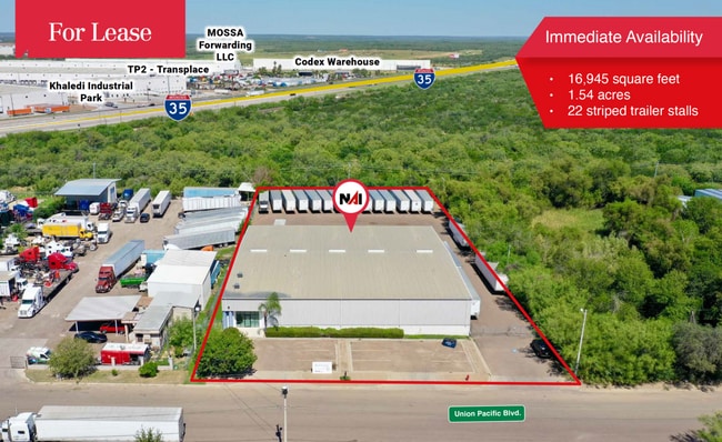


Property Detail
310 Union Pacific Blvd
319322
LOT 5 BLK 1 MILO DIST CTR I
Commercialnec
Webb
M1
Texas
A Areas with a 1% annual chance of flooding and a 26% chance of flooding over the life of a 30-year mortgage.
5
2024
1.54 AC
2025
Texas South Area
001726
Other Market Areas
18,218 SF
Laredo, TX
NEARBY LISTINGS FOR SALE OR LEASE
DEMOGRAPHICS near 310 Union Pacific Blvd
1 mile
3 mile
5 mile
2025 Total Population
718
56,391
94,001
2030 Population
754
57,666
96,281
Pop Growth 2025-2030
+ 5.01%
+ 2.26%
+ 2.43%
Average Age
34
35
35
2025 Total Households
225
17,051
29,255
HH Growth 2025-2030
+ 5.33%
+ 2.50%
+ 2.66%
Median Household Inc
$78,488
$84,809
$82,287
Avg Household Size
3.20
3.30
3.20
2025 Avg HH Vehicles
2.00
2.00
2.00
Median Home Value
$287,313
$252,634
$261,190
Median Year Built
2009
2003
2001
Nearby Places
Map Layers
Map Styles
 Street
 Aerial
Layers
 Traffic
 Biking
Places
Listings with unknown addresses are not visible on the map
- Restaurants
- Banks
- Shops
- Fitness
- Groceries
PUBLIC TRANSPORTATION
AIRPORT
Laredo International
Drive
Walk
Distance
Laredo International
14 min
8.8 mi
SALE & LEASE HISTORY
LISTING DATE
SALE/LEASE

Jun 11, 2018
For Lease
Dec 06, 2017
For Lease
Aug 06, 2019
For Lease
Apr 23, 2025
For Lease
Nearby Properties
Address
Land Use
TOTAL SIZE
Lot Size
Zoning
Address
Land Use
TOTAL SIZE
Lot Size
Zoning
430,587 SF
30 AC
R1
Address
Land Use
TOTAL SIZE
Lot Size
Zoning
251,512 SF
57.32 AC
B4
Address
Land Use
TOTAL SIZE
Lot Size
Zoning
255,819 SF
50 AC
R1
Address
Land Use
TOTAL SIZE
Lot Size
Zoning
436,814 SF
27.66 AC
Address
Land Use
TOTAL SIZE
Lot Size
Zoning
206,224 SF
20.03 AC
R1
Address
Land Use
TOTAL SIZE
Lot Size
Zoning
649,220 SF
38.29 AC
M1
Address
Land Use
TOTAL SIZE
Lot Size
Zoning
562,944 SF
30 AC
M1
Address
Land Use
TOTAL SIZE
Lot Size
Zoning
370,800 SF
40.09 AC
Address
Land Use
TOTAL SIZE
Lot Size
Zoning
521,026 SF
30 AC
M1
Address
Land Use
TOTAL SIZE
Lot Size
Zoning
164,276 SF
43.92 AC
Address
Land Use
TOTAL SIZE
Lot Size
Zoning
286,008 SF
37.30 AC
Address
Land Use
TOTAL SIZE
Lot Size
Zoning
109,695 SF
3.73 AC
M1
Address
Land Use
TOTAL SIZE
Lot Size
Zoning
194,520 SF
11.18 AC
B3
Address
Land Use
TOTAL SIZE
Lot Size
Zoning
115,076 SF
32.87 AC
Address
Land Use
TOTAL SIZE
Lot Size
Zoning
192,203 SF
22.01 AC
B4
Address
Land Use
TOTAL SIZE
Lot Size
Zoning
136,981 SF
10.01 AC
Address
Land Use
TOTAL SIZE
Lot Size
Zoning
218,415 SF
13.41 AC
R3
Address
Land Use
TOTAL SIZE
Lot Size
Zoning
170,632 SF
8.03 AC
B3
Address
Land Use
TOTAL SIZE
Lot Size
Zoning
257,516 SF
21.94 AC
Address
Land Use
TOTAL SIZE
Lot Size
Zoning
243,399 SF
15.50 AC
Address
Land Use
TOTAL SIZE
Lot Size
Zoning
162,013 SF
9.16 AC
B1
Address
Land Use
TOTAL SIZE
Lot Size
Zoning
246,003 SF
24.32 AC
Address
Land Use
TOTAL SIZE
Lot Size
Zoning
100,598 SF
26.22 AC
Address
Land Use
TOTAL SIZE
Lot Size
Zoning
118,124 SF
11.30 AC
R1A
Address
Land Use
TOTAL SIZE
Lot Size
Zoning
228,046 SF
13.58 AC
Address
Land Use
TOTAL SIZE
Lot Size
Zoning
96,665 SF
11.12 AC
R1A
Address
Land Use
TOTAL SIZE
Lot Size
Zoning
93,707 SF
12.29 AC
Address
Land Use
TOTAL SIZE
Lot Size
Zoning
253,180 SF
16.56 AC
M1
Address
Land Use
TOTAL SIZE
Lot Size
Zoning
264,984 SF
18.70 AC
Address
Land Use
TOTAL SIZE
Lot Size
Zoning
98,998 SF
10.31 AC
B3
The World's #1 Commercial Real Estate Marketplace
Connect with us
© 2026 CoStar Group
The information above has been obtained from sources believed reliable. While we do not doubt its accuracy we have not verified it and make no guarantee, warranty or representation about it. It is your responsibility to independently confirm its accuracy and completeness. Any projections, opinions, assumptions, or estimates used are for example only and do not represent the current or future performance of the property. The value of this transaction to you depends on tax and other factors which should be evaluated by your tax, financial, and legal advisors. You and your advisors should conduct a careful, independent investigation of the property to determine to your satisfaction the suitability of the property for your needs.