Property Record
310 Wamsutta Dr, Lyman, SC 29365

Save to a Folder
{{folder.Name}}
{{folder.ListingIds.length}} Properties
{{folder.ListingIds.length}} Property
Create a New Folder
Property Detail
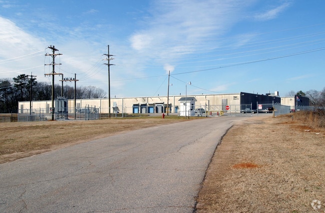
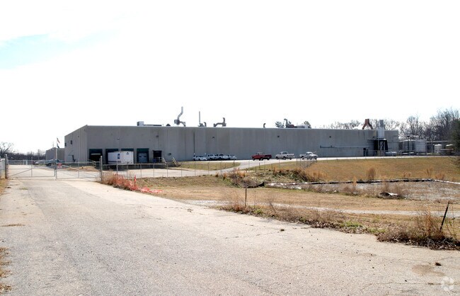
310 Wamsutta Dr
5-15-00-006.04
S SIIDE WAMSUTTA DR & W OF GROCE RD PB 159-104 PB 175-754
Industrialgeneral
SPARTANBURG
B and X Area of moderate flood hazard, usually the area between the limits of the 100-year and 500-year floods.
South Carolina
2022
8.02 AC
2025
Upper Spartanburg Cty
023004
Greenville/Spartanburg
67,938 SF
Spartanburg, SC
NEARBY LISTINGS FOR SALE OR LEASE
DEMOGRAPHICS near 310 Wamsutta Dr
1 mile
3 mile
5 mile
2025 Total Population
3,613
23,230
54,905
2030 Population
4,034
25,897
61,309
Pop Growth 2025-2030
+ 11.65%
+ 11.48%
+ 11.66%
Average Age
37
37
38
2025 Total Households
1,466
8,776
20,246
HH Growth 2025-2030
+ 11.66%
+ 11.50%
+ 11.80%
Median Household Inc
$52,655
$62,106
$68,585
Avg Household Size
2.50
2.60
2.60
2025 Avg HH Vehicles
2.00
2.00
2.00
Median Home Value
$205,190
$239,796
$258,444
Median Year Built
1988
1995
1999
Nearby Places
Map Layers
Map Styles
 Street
 Aerial
Layers
 Traffic
 Biking
Places
Listings with unknown addresses are not visible on the map
- Restaurants
- Banks
- Shops
- Fitness
- Groceries
PUBLIC TRANSPORTATION
AIRPORT
Greenville Spartanburg International
Drive
Walk
Distance
Greenville Spartanburg International
16 min
8.7 mi
SALE & LEASE HISTORY
LISTING DATE
SALE/LEASE

Mar 10, 2017
For Lease
Nearby Properties
Address
Land Use
TOTAL SIZE
Lot Size
Zoning
Address
Land Use
TOTAL SIZE
Lot Size
Zoning
451,000 SF
47.03 AC
Address
Land Use
TOTAL SIZE
Lot Size
Zoning
227,627 SF
21.37 AC
Address
Land Use
TOTAL SIZE
Lot Size
Zoning
241,696 SF
15.12 AC
Address
Land Use
TOTAL SIZE
Lot Size
Zoning
873,910 SF
31.46 AC
Address
Land Use
TOTAL SIZE
Lot Size
Zoning
318,450 SF
22.63 AC
Address
Land Use
TOTAL SIZE
Lot Size
Zoning
303,442 SF
21.23 AC
Address
Land Use
TOTAL SIZE
Lot Size
Zoning
185,745 SF
14.17 AC
Address
Land Use
TOTAL SIZE
Lot Size
Zoning
61,536 SF
16.16 AC
Address
Land Use
TOTAL SIZE
Lot Size
Zoning
Address
Land Use
TOTAL SIZE
Lot Size
Zoning
2,528 SF
14.74 AC
Address
Land Use
TOTAL SIZE
Lot Size
Zoning
102.67 AC
Address
Land Use
TOTAL SIZE
Lot Size
Zoning
111.08 AC
Address
Land Use
TOTAL SIZE
Lot Size
Zoning
417,082 SF
10 AC
Address
Land Use
TOTAL SIZE
Lot Size
Zoning
1,281 SF
41.23 AC
Address
Land Use
TOTAL SIZE
Lot Size
Zoning
33.57 AC
Address
Land Use
TOTAL SIZE
Lot Size
Zoning
42.27 AC
Address
Land Use
TOTAL SIZE
Lot Size
Zoning
2,497 SF
12.36 AC
Address
Land Use
TOTAL SIZE
Lot Size
Zoning
26,472 SF
3.90 AC
Address
Land Use
TOTAL SIZE
Lot Size
Zoning
2,088 SF
40.12 AC
Address
Land Use
TOTAL SIZE
Lot Size
Zoning
736,169 SF
24.99 AC
Address
Land Use
TOTAL SIZE
Lot Size
Zoning
1,964,569 SF
46.64 AC
Address
Land Use
TOTAL SIZE
Lot Size
Zoning
33.40 AC
Address
Land Use
TOTAL SIZE
Lot Size
Zoning
1,798 SF
9.63 AC
Address
Land Use
TOTAL SIZE
Lot Size
Zoning
18.27 AC
Address
Land Use
TOTAL SIZE
Lot Size
Zoning
28.26 AC
Address
Land Use
TOTAL SIZE
Lot Size
Zoning
Address
Land Use
TOTAL SIZE
Lot Size
Zoning
60,668 SF
8.02 AC
Address
Land Use
TOTAL SIZE
Lot Size
Zoning
32,310 SF
13.72 AC
Address
Land Use
TOTAL SIZE
Lot Size
Zoning
1,176 SF
20.13 AC
The World's #1 Commercial Real Estate Marketplace
Connect with us
© 2026 CoStar Group
The information above has been obtained from sources believed reliable. While we do not doubt its accuracy we have not verified it and make no guarantee, warranty or representation about it. It is your responsibility to independently confirm its accuracy and completeness. Any projections, opinions, assumptions, or estimates used are for example only and do not represent the current or future performance of the property. The value of this transaction to you depends on tax and other factors which should be evaluated by your tax, financial, and legal advisors. You and your advisors should conduct a careful, independent investigation of the property to determine to your satisfaction the suitability of the property for your needs.