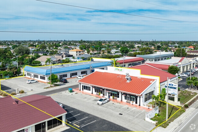
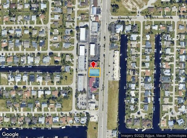
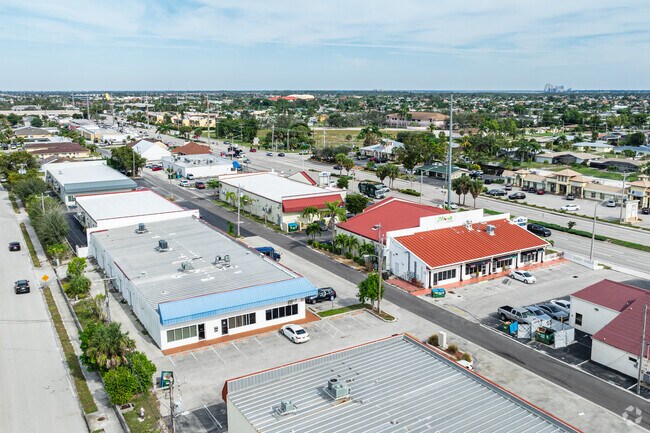
Property Record
3100 Del Prado Blvd S, Cape Coral, FL 33904
NEARBY LISTINGS FOR SALE OR LEASE
Property Detail
3100 Del Prado Blvd S
Cape Coral-Fort Myers, FL
Cape Coral
31-44-24-C3-00551.0660
CAPE CORAL UNIT 21 BLK 551 PB 13 PG 152 LOTS 66 + 67 + N 16 FT LOT 65
Restaurantbuilding
Lee
X
Florida
12071C0402G
65-67
2024
0.28 AC
2025
Cape Coral
010601
Southwest Florida
2,805 SF
DEMOGRAPHICS near 3100 Del Prado Blvd S
1 Mile
3 Mile
5 Mile
2024 Total Population
8,856
63,678
195,635
2029 Population
10,443
75,015
231,011
Pop Growth 2024-2029
+ 17.92%
+ 17.80%
+ 18.08%
Average Age
50
47
46
2024 Total Households
3,819
27,418
83,551
HH Growth 2024-2029
+ 17.54%
+ 17.48%
+ 17.74%
Median Household Inc
$65,936
$62,151
$62,080
Avg Household Size
2.20
2.30
2.30
2024 Avg HH Vehicles
2.00
2.00
2.00
Median Home Value
$318,624
$291,278
$287,180
Median Year Built
1980
1986
1987
Nearby Places
Map Layers
Map Styles
 Street
 Aerial
- Restaurants
- Banks
- Shops
- Fitness
- Groceries
PUBLIC TRANSPORTATION
AIRPORT
Southwest Florida International
DRIVE
WALK
Distance
Southwest Florida International
31 min
15.6 mi
Punta Gorda
DRIVE
WALK
Distance
Punta Gorda
43 min
27.5 mi
SALE & LEASE HISTORY
LISTING DATE
SALE/LEASE

Mar 12, 2025
For Sale
Jan 20, 2025
For Sale
Nearby Properties
Address
Land Use
TOTAL SIZE
Lot Size
Zoning
Address
Land Use
TOTAL SIZE
Lot Size
Zoning
476,419 SF
36.49 AC
C1
Address
Land Use
TOTAL SIZE
Lot Size
Zoning
282,066 SF
39.45 AC
INS
Address
Land Use
TOTAL SIZE
Lot Size
Zoning
278,679 SF
29.21 AC
C1-D
Address
Land Use
TOTAL SIZE
Lot Size
Zoning
101,204 SF
12.34 AC
P1-D
Address
Land Use
TOTAL SIZE
Lot Size
Zoning
139,978 SF
10.75 AC
C-1
Address
Land Use
TOTAL SIZE
Lot Size
Zoning
142,773 SF
10.82 AC
C-1
Address
Land Use
TOTAL SIZE
Lot Size
Zoning
144,607 SF
20 AC
INS
Address
Land Use
TOTAL SIZE
Lot Size
Zoning
54,248 SF
15.42 AC
C1-W
Address
Land Use
TOTAL SIZE
Lot Size
Zoning
101,999 SF
7.17 AC
P-1
Address
Land Use
TOTAL SIZE
Lot Size
Zoning
99,749 SF
11.49 AC
WSHP
Address
Land Use
TOTAL SIZE
Lot Size
Zoning
113,239 SF
12.62 AC
R1-D
Address
Land Use
TOTAL SIZE
Lot Size
Zoning
227,560 SF
27.45 AC
C1-D
Address
Land Use
TOTAL SIZE
Lot Size
Zoning
47,660 SF
3.52 AC
C1-D
Address
Land Use
TOTAL SIZE
Lot Size
Zoning
95,942 SF
5.22 AC
C1-D
Address
Land Use
TOTAL SIZE
Lot Size
Zoning
78,988 SF
2.89 AC
C1-D
Address
Land Use
TOTAL SIZE
Lot Size
Zoning
52,003 SF
6.66 AC
WSHP
Address
Land Use
TOTAL SIZE
Lot Size
Zoning
69,261 SF
8.44 AC
WSHP
Address
Land Use
TOTAL SIZE
Lot Size
Zoning
84,145 SF
8.11 AC
C-1
Address
Land Use
TOTAL SIZE
Lot Size
Zoning
74,368 SF
2.32 AC
SC
Address
Land Use
TOTAL SIZE
Lot Size
Zoning
36,649 SF
2.82 AC
C-1
Address
Land Use
TOTAL SIZE
Lot Size
Zoning
201,687 SF
11.80 AC
C-1
Address
Land Use
TOTAL SIZE
Lot Size
Zoning
53,979 SF
3.24 AC
P-1
Address
Land Use
TOTAL SIZE
Lot Size
Zoning
52,459 SF
9.22 AC
C-1
Address
Land Use
TOTAL SIZE
Lot Size
Zoning
86,497 SF
6.20 AC
SC
Address
Land Use
TOTAL SIZE
Lot Size
Zoning
139,446 SF
9.94 AC
C1-D
Address
Land Use
TOTAL SIZE
Lot Size
Zoning
45,809 SF
1.75 AC
SC
Address
Land Use
TOTAL SIZE
Lot Size
Zoning
34,482 SF
2.39 AC
C-1
Address
Land Use
TOTAL SIZE
Lot Size
Zoning
51,688 SF
3.60 AC
C-1
Address
Land Use
TOTAL SIZE
Lot Size
Zoning
67,396 SF
2.02 AC
SC
Address
Land Use
TOTAL SIZE
Lot Size
Zoning
1,098 SF
3.58 AC
RS-1
The World's #1 Commercial Real Estate Marketplace
Connect with us
© 2025 CoStar Group
The information above has been obtained from sources believed reliable. While we do not doubt its accuracy we have not verified it and make no guarantee, warranty or representation about it. It is your responsibility to independently confirm its accuracy and completeness. Any projections, opinions, assumptions, or estimates used are for example only and do not represent the current or future performance of the property. The value of this transaction to you depends on tax and other factors which should be evaluated by your tax, financial, and legal advisors. You and your advisors should conduct a careful, independent investigation of the property to determine to your satisfaction the suitability of the property for your needs.