Property Record
3100 Hawthorne St, Sarasota, FL 34239
NEARBY LISTINGS FOR SALE OR LEASE
Property Detail
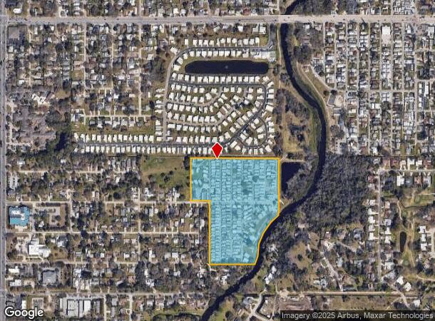
3100 Hawthorne St
North Port-Sarasota-Bradenton, FL
Not Part Of A Subdivision
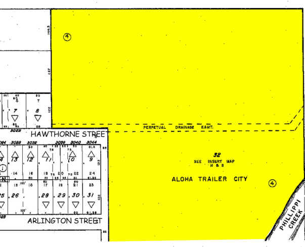
0055-11-0032
E 186.58 FT OF BLKS L & M OF RIO VISTA RESUB & THAT PART OF E 1/2 OF SE 1/4 OF SW 1/4 OF SEC 28-36-18 LYING N & W OF PHILLIPPI CREEK LESS S 294 FT THEREOF, LESS PERPETUAL DRAINAGE ESMT DESC IN
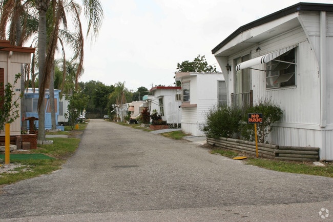
Parkinglot
Sarasota
AE
Florida
12115C0134G
m
2024
16.20 AC
2025
South Sarasota
000503
Tampa/St Petersburg
4,698 SF
DEMOGRAPHICS near 3100 Hawthorne St
1 Mile
3 Mile
5 Mile
2024 Total Population
11,354
94,392
195,563
2029 Population
13,029
107,859
225,186
Pop Growth 2024-2029
+ 14.75%
+ 14.27%
+ 15.15%
Average Age
47
46
48
2024 Total Households
5,086
42,634
89,075
HH Growth 2024-2029
+ 14.83%
+ 14.40%
+ 15.34%
Median Household Inc
$57,183
$66,698
$70,640
Avg Household Size
2.10
2.10
2.10
2024 Avg HH Vehicles
1.00
2.00
2.00
Median Home Value
$314,989
$322,586
$347,869
Median Year Built
1967
1976
1979
Nearby Places
Map Layers
Map Styles
 Street
 Aerial
- Restaurants
- Banks
- Shops
- Fitness
- Groceries
PUBLIC TRANSPORTATION
AIRPORT
Sarasota/Bradenton International
DRIVE
WALK
Distance
Sarasota/Bradenton International
17 min
8.1 mi
Freight Ports
Port Manatee
DRIVE
WALK
Distance
Port Manatee
44 min
26.1 mi
Nearby Properties
Address
Land Use
TOTAL SIZE
Lot Size
Zoning
Address
Land Use
TOTAL SIZE
Lot Size
Zoning
2,010,667 SF
14.38 AC
SMH
Address
Land Use
TOTAL SIZE
Lot Size
Zoning
843,350 SF
5.13 AC
DTC
Address
Land Use
TOTAL SIZE
Lot Size
Zoning
516,332 SF
7.62 AC
DTB
Address
Land Use
TOTAL SIZE
Lot Size
Zoning
439,798 SF
4.20 AC
DTC
Address
Land Use
TOTAL SIZE
Lot Size
Zoning
588,839 SF
42.33 AC
GU
Address
Land Use
TOTAL SIZE
Lot Size
Zoning
595,734 SF
1.63 AC
DTB
Address
Land Use
TOTAL SIZE
Lot Size
Zoning
458,955 SF
3.99 AC
DTE
Address
Land Use
TOTAL SIZE
Lot Size
Zoning
409,998 SF
1.09 AC
DTC
Address
Land Use
TOTAL SIZE
Lot Size
Zoning
950 SF
26.80 AC
G
Address
Land Use
TOTAL SIZE
Lot Size
Zoning
432,668 SF
72.05 AC
GU
Address
Land Use
TOTAL SIZE
Lot Size
Zoning
394,304 SF
2.85 AC
DTE
Address
Land Use
TOTAL SIZE
Lot Size
Zoning
425,532 SF
3.05 AC
DTE
Address
Land Use
TOTAL SIZE
Lot Size
Zoning
415,689 SF
37.52 AC
OPI
Address
Land Use
TOTAL SIZE
Lot Size
Zoning
463,072 SF
2.21 AC
DTC
Address
Land Use
TOTAL SIZE
Lot Size
Zoning
1.70 AC
DTB
Address
Land Use
TOTAL SIZE
Lot Size
Zoning
223,241 SF
7.80 AC
DTE
Address
Land Use
TOTAL SIZE
Lot Size
Zoning
321,015 SF
1.11 AC
DTB
Address
Land Use
TOTAL SIZE
Lot Size
Zoning
263,961 SF
18.88 AC
RMF3
Address
Land Use
TOTAL SIZE
Lot Size
Zoning
91,324 SF
2.18 AC
SMH
Address
Land Use
TOTAL SIZE
Lot Size
Zoning
146,948 SF
1.08 AC
SMH
Address
Land Use
TOTAL SIZE
Lot Size
Zoning
199,653 SF
0.38 AC
DTC
Address
Land Use
TOTAL SIZE
Lot Size
Zoning
216,684 SF
30.52 AC
RMF2
Address
Land Use
TOTAL SIZE
Lot Size
Zoning
298,970 SF
38.78 AC
G
Address
Land Use
TOTAL SIZE
Lot Size
Zoning
19,464 SF
38.95 AC
G
Address
Land Use
TOTAL SIZE
Lot Size
Zoning
286,339 SF
44.66 AC
G
Address
Land Use
TOTAL SIZE
Lot Size
Zoning
211,459 SF
2.36 AC
DTC
Address
Land Use
TOTAL SIZE
Lot Size
Zoning
258,407 SF
18.55 AC
RMF3
Address
Land Use
TOTAL SIZE
Lot Size
Zoning
237,930 SF
1.58 AC
DTC
Address
Land Use
TOTAL SIZE
Lot Size
Zoning
112,310 SF
36.83 AC
G
Address
Land Use
TOTAL SIZE
Lot Size
Zoning
209,091 SF
21.30 AC
RMF3
The World's #1 Commercial Real Estate Marketplace
Connect with us
© 2025 CoStar Group
The information above has been obtained from sources believed reliable. While we do not doubt its accuracy we have not verified it and make no guarantee, warranty or representation about it. It is your responsibility to independently confirm its accuracy and completeness. Any projections, opinions, assumptions, or estimates used are for example only and do not represent the current or future performance of the property. The value of this transaction to you depends on tax and other factors which should be evaluated by your tax, financial, and legal advisors. You and your advisors should conduct a careful, independent investigation of the property to determine to your satisfaction the suitability of the property for your needs.