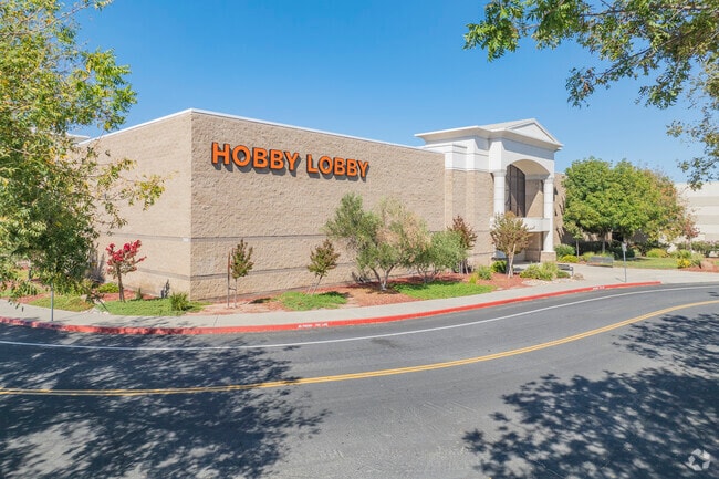
Property Record
3100 Naglee Rd, Tracy, CA 95304

NEARBY LISTINGS FOR SALE OR LEASE
Property Detail
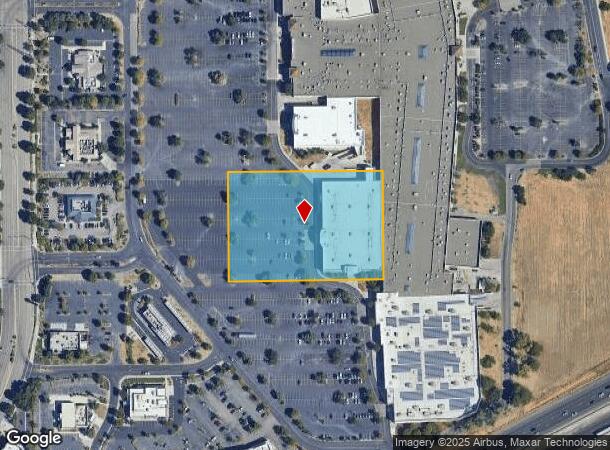
3100 Naglee Rd
Stockton-Lodi, CA
Tracy Garden Farms
212-050-22
96-FM PT OF 12/PT TO 21/23 THRU 27 PM 20-31
Departmentstore
San Joaquin
X
California
06077C0590F
2
2025
3.71 AC
2025
Tracy/Manteca
005225
Stockton/Modesto
51,492 SF
DEMOGRAPHICS near 3100 Naglee Rd
1 mile
3 mile
5 mile
2024 Total Population
10,111
69,575
115,511
2029 Population
10,631
73,416
122,321
Pop Growth 2024-2029
+ 5.14%
+ 5.52%
+ 5.90%
Average Age
37
37
37
2024 Total Households
2,968
21,001
34,227
HH Growth 2024-2029
+ 5.19%
+ 5.54%
+ 5.93%
Median Household Inc
$95,862
$102,142
$114,257
Avg Household Size
3.40
3.20
3.30
2024 Avg HH Vehicles
3.00
2.00
3.00
Median Home Value
$632,593
$588,381
$649,164
Median Year Built
1992
1990
1996
Nearby Places
Map Layers
Map Styles
 Street
 Aerial
Transit
 Traffic
 Biking
Places
Listings with unknown addresses are not visible on the map
- Restaurants
- Banks
- Shops
- Fitness
- Groceries
PUBLIC TRANSPORTATION
COMMUTER RAIL
Tracy Station (ACE Train - Altamont Corridor Express)
Drive
Walk
Distance
Tracy Station (ACE Train - Altamont Corridor Express)
12 min
6.3 mi
Tracy (Altamont Corridor Express - Altamont Commuter Express (ACE))
Drive
Walk
Distance
Tracy (Altamont Corridor Express - Altamont Commuter Express (ACE))
11 min
6.3 mi
AIRPORT
Stockton Metro
Drive
Walk
Distance
Stockton Metro
27 min
20.8 mi
Freight Ports
Port of Stockton
Drive
Walk
Distance
Port of Stockton
30 min
24.1 mi
Nearby Properties
Address
Land Use
TOTAL SIZE
Lot Size
Zoning
Address
Land Use
TOTAL SIZE
Lot Size
Zoning
1,120,082 SF
94.93 AC
AG40
Address
Land Use
TOTAL SIZE
Lot Size
Zoning
610,914 SF
28.11 AC
M1
Address
Land Use
TOTAL SIZE
Lot Size
Zoning
8.90 AC
Address
Land Use
TOTAL SIZE
Lot Size
Zoning
925,475 SF
42.09 AC
Address
Land Use
TOTAL SIZE
Lot Size
Zoning
1,601 SF
17.08 AC
PUD1
Address
Land Use
TOTAL SIZE
Lot Size
Zoning
3.77 AC
Address
Land Use
TOTAL SIZE
Lot Size
Zoning
795,732 SF
36.67 AC
IG
Address
Land Use
TOTAL SIZE
Lot Size
Zoning
10.15 AC
PUD1
Address
Land Use
TOTAL SIZE
Lot Size
Zoning
461,810 SF
23.23 AC
PUD3
Address
Land Use
TOTAL SIZE
Lot Size
Zoning
9,327 SF
12.06 AC
Address
Land Use
TOTAL SIZE
Lot Size
Zoning
22,726 SF
8.96 AC
PUD1
Address
Land Use
TOTAL SIZE
Lot Size
Zoning
442,350 SF
27.01 AC
CN
Address
Land Use
TOTAL SIZE
Lot Size
Zoning
575,167 SF
46.44 AC
Address
Land Use
TOTAL SIZE
Lot Size
Zoning
265,868 SF
11.99 AC
Address
Land Use
TOTAL SIZE
Lot Size
Zoning
265,000 SF
10.83 AC
Address
Land Use
TOTAL SIZE
Lot Size
Zoning
49,264 SF
9 AC
Address
Land Use
TOTAL SIZE
Lot Size
Zoning
148,663 SF
16.37 AC
Address
Land Use
TOTAL SIZE
Lot Size
Zoning
225,000 SF
11.13 AC
M
Address
Land Use
TOTAL SIZE
Lot Size
Zoning
126,204 SF
110.07 AC
Address
Land Use
TOTAL SIZE
Lot Size
Zoning
155,942 SF
11.90 AC
Address
Land Use
TOTAL SIZE
Lot Size
Zoning
95.54 AC
Address
Land Use
TOTAL SIZE
Lot Size
Zoning
64,582 SF
3.10 AC
Address
Land Use
TOTAL SIZE
Lot Size
Zoning
190,388 SF
13.50 AC
Address
Land Use
TOTAL SIZE
Lot Size
Zoning
1,347 SF
4.96 AC
Address
Land Use
TOTAL SIZE
Lot Size
Zoning
155,518 SF
12.67 AC
Address
Land Use
TOTAL SIZE
Lot Size
Zoning
55,576 SF
2.65 AC
Address
Land Use
TOTAL SIZE
Lot Size
Zoning
109,438 SF
6.23 AC
The World's #1 Commercial Real Estate Marketplace
Connect with us
© 2026 CoStar Group
The information above has been obtained from sources believed reliable. While we do not doubt its accuracy we have not verified it and make no guarantee, warranty or representation about it. It is your responsibility to independently confirm its accuracy and completeness. Any projections, opinions, assumptions, or estimates used are for example only and do not represent the current or future performance of the property. The value of this transaction to you depends on tax and other factors which should be evaluated by your tax, financial, and legal advisors. You and your advisors should conduct a careful, independent investigation of the property to determine to your satisfaction the suitability of the property for your needs.