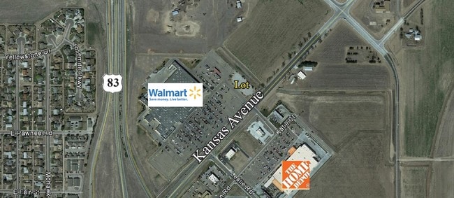
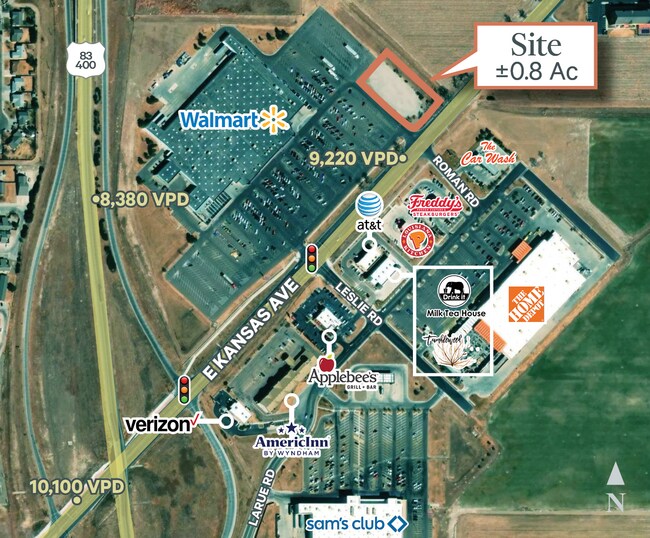
Property Record
3101 E Kansas Ave, Garden City, KS 67846

NEARBY LISTINGS FOR SALE OR LEASE
Property Detail
3101 E Kansas Ave
Garden City, KS
S09, T24, R32W, ACRES 28.5, A TR BEG 750' E & 30' S NW COR NE4 TH E 219' TH S 632' TH SELY 460.6' TH SWLY 933.6' TH SWLY 200.
272-09-0-00-01-009.02-0
Finney
Wholesaleoutletdiscountstore
Kansas
2025
28.50 AC
2025
Kansas Area
960403
Other Market Areas
204,578 SF
DEMOGRAPHICS near 3101 E Kansas Ave
1 Mile
3 Mile
5 Mile
2024 Total Population
3,711
26,481
32,781
2029 Population
3,587
25,620
31,797
Pop Growth 2024-2029
(3.34%)
(3.25%)
(3.00%)
Average Age
36
35
35
2024 Total Households
1,354
9,137
11,215
HH Growth 2024-2029
(3.47%)
(3.27%)
(3.02%)
Median Household Inc
$69,756
$62,783
$63,205
Avg Household Size
2.70
2.80
2.80
2024 Avg HH Vehicles
2.00
2.00
2.00
Median Home Value
$201,706
$163,144
$163,081
Median Year Built
1986
1975
1976
Nearby Places
Map Layers
Map Styles
 Street
 Aerial
- Restaurants
- Banks
- Shops
- Fitness
- Groceries
PUBLIC TRANSPORTATION
COMMUTER RAIL
Garden City Amtrak Station (Southwest Chief - Amtrak)
DRIVE
WALK
Distance
Garden City Amtrak Station (Southwest Chief - Amtrak)
5 min
3.2 mi
Freight Ports
Tulsa Port Of Catoosa
DRIVE
WALK
Distance
Tulsa Port Of Catoosa
453 min
395.0 mi
SALE & LEASE HISTORY
LISTING DATE
SALE/LEASE

Sep 24, 2016
For Sale
Sep 08, 2017
For Sale
Oct 10, 2023
For Sale
Nearby Properties
Address
Land Use
TOTAL SIZE
Lot Size
Zoning
Address
Land Use
TOTAL SIZE
Lot Size
Zoning
485,653 SF
107.22 AC
Address
Land Use
TOTAL SIZE
Lot Size
Zoning
21,733 SF
60.54 AC
PF
Address
Land Use
TOTAL SIZE
Lot Size
Zoning
182,177 SF
22.83 AC
R2
Address
Land Use
TOTAL SIZE
Lot Size
Zoning
73,757 SF
25.61 AC
A
Address
Land Use
TOTAL SIZE
Lot Size
Zoning
86,664 SF
1.25 AC
CO
Address
Land Use
TOTAL SIZE
Lot Size
Zoning
6,300 SF
55.93 AC
Address
Land Use
TOTAL SIZE
Lot Size
Zoning
90,384 SF
27.14 AC
R2
Address
Land Use
TOTAL SIZE
Lot Size
Zoning
2,720 SF
13.43 AC
A
Address
Land Use
TOTAL SIZE
Lot Size
Zoning
39,413 SF
7.39 AC
R1
Address
Land Use
TOTAL SIZE
Lot Size
Zoning
38,748 SF
30.25 AC
R3
Address
Land Use
TOTAL SIZE
Lot Size
Zoning
91,579 SF
9.37 AC
R2
Address
Land Use
TOTAL SIZE
Lot Size
Zoning
38,151 SF
9.04 AC
R3
Address
Land Use
TOTAL SIZE
Lot Size
Zoning
69,088 SF
12.86 AC
Address
Land Use
TOTAL SIZE
Lot Size
Zoning
37,343 SF
12.42 AC
A
Address
Land Use
TOTAL SIZE
Lot Size
Zoning
64,065 SF
7.91 AC
R1
Address
Land Use
TOTAL SIZE
Lot Size
Zoning
69,088 SF
13.95 AC
A
Address
Land Use
TOTAL SIZE
Lot Size
Zoning
27,433 SF
1.81 AC
R4
Address
Land Use
TOTAL SIZE
Lot Size
Zoning
44,962 SF
19.78 AC
A
Address
Land Use
TOTAL SIZE
Lot Size
Zoning
21,875 SF
17.05 AC
I3
Address
Land Use
TOTAL SIZE
Lot Size
Zoning
28,917 SF
3.99 AC
A
Address
Land Use
TOTAL SIZE
Lot Size
Zoning
64,277 SF
4.97 AC
R2
Address
Land Use
TOTAL SIZE
Lot Size
Zoning
17,938 SF
3.90 AC
I3
Address
Land Use
TOTAL SIZE
Lot Size
Zoning
60,280 SF
15.25 AC
A
Address
Land Use
TOTAL SIZE
Lot Size
Zoning
52,727 SF
4.58 AC
R4
Address
Land Use
TOTAL SIZE
Lot Size
Zoning
182,192 SF
24.54 AC
Address
Land Use
TOTAL SIZE
Lot Size
Zoning
51,489 SF
3.34 AC
R2
Address
Land Use
TOTAL SIZE
Lot Size
Zoning
121,301 SF
15.46 AC
A
Address
Land Use
TOTAL SIZE
Lot Size
Zoning
21,794 SF
3.12 AC
Address
Land Use
TOTAL SIZE
Lot Size
Zoning
22,578 SF
1.23 AC
C0
Address
Land Use
TOTAL SIZE
Lot Size
Zoning
46,619 SF
3.46 AC
R1
The World's #1 Commercial Real Estate Marketplace
Connect with us
© 2026 CoStar Group
The information above has been obtained from sources believed reliable. While we do not doubt its accuracy we have not verified it and make no guarantee, warranty or representation about it. It is your responsibility to independently confirm its accuracy and completeness. Any projections, opinions, assumptions, or estimates used are for example only and do not represent the current or future performance of the property. The value of this transaction to you depends on tax and other factors which should be evaluated by your tax, financial, and legal advisors. You and your advisors should conduct a careful, independent investigation of the property to determine to your satisfaction the suitability of the property for your needs.