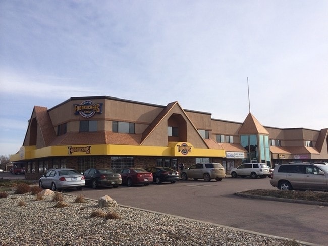
Property Record
3109 W Park Place Cir, Sioux Falls, SD 57105

Current Lease Availabilities
Property Detail
3109 W Park Place Cir
29832
TRACT 2 (EX W20 & EX H-1) DAKOTA INVESTMENT FIRST ADDN TO CITY OF SIOUX FALLS
Stripcommercialcenter
MINNEHAHA
FP;FP
South Dakota
2024
4.26 AC
2024
Sioux Falls
001501
Other Market Areas
30,752 SF
Sioux Falls, SD-MN
NEARBY LISTINGS FOR SALE OR LEASE
DEMOGRAPHICS near 3109 W Park Place Cir
1 mile
3 mile
5 mile
2025 Total Population
8,410
94,302
184,150
2030 Population
8,768
100,312
196,301
Pop Growth 2025-2030
+ 4.26%
+ 6.37%
+ 6.60%
Average Age
41
39
38
2025 Total Households
4,169
40,525
76,117
HH Growth 2025-2030
+ 4.73%
+ 6.72%
+ 7.05%
Median Household Inc
$48,258
$69,626
$70,792
Avg Household Size
1.90
2.20
2.30
2025 Avg HH Vehicles
1.00
2.00
2.00
Median Home Value
$258,692
$289,058
$296,045
Median Year Built
1976
1987
1994
Nearby Places
Map Layers
Map Styles
 Street
 Aerial
Layers
 Traffic
 Biking
Places
Listings with unknown addresses are not visible on the map
- Restaurants
- Banks
- Shops
- Fitness
- Groceries
PUBLIC TRANSPORTATION
AIRPORT
Joe Foss Field
Drive
Walk
Distance
Joe Foss Field
25 min
6.8 mi
Freight Ports
Port Milwaukee
Drive
Walk
Distance
Port Milwaukee
552 min
508.1 mi
Nearby Properties
Address
Land Use
TOTAL SIZE
Lot Size
Zoning
Address
Land Use
TOTAL SIZE
Lot Size
Zoning
14.81 AC
MUNICIPALI
Address
Land Use
TOTAL SIZE
Lot Size
Zoning
80,415 SF
13.13 AC
Address
Land Use
TOTAL SIZE
Lot Size
Zoning
8.89 AC
MUNICIPALI
Address
Land Use
TOTAL SIZE
Lot Size
Zoning
639,393 SF
53.46 AC
FP;FP
Address
Land Use
TOTAL SIZE
Lot Size
Zoning
8.90 AC
C1;NEIGHBO
Address
Land Use
TOTAL SIZE
Lot Size
Zoning
Address
Land Use
TOTAL SIZE
Lot Size
Zoning
8.80 AC
MUNICIPALI
Address
Land Use
TOTAL SIZE
Lot Size
Zoning
184,821 SF
1.83 AC
NO;SPECIAL
Address
Land Use
TOTAL SIZE
Lot Size
Zoning
7,252 SF
12.07 AC
Address
Land Use
TOTAL SIZE
Lot Size
Zoning
9.41 AC
Address
Land Use
TOTAL SIZE
Lot Size
Zoning
360,262 SF
26 AC
Address
Land Use
TOTAL SIZE
Lot Size
Zoning
15,704 SF
5.13 AC
Address
Land Use
TOTAL SIZE
Lot Size
Zoning
55,998 SF
5.42 AC
FP;FP
Address
Land Use
TOTAL SIZE
Lot Size
Zoning
51,004 SF
3.99 AC
Address
Land Use
TOTAL SIZE
Lot Size
Zoning
72,553 SF
0.97 AC
Address
Land Use
TOTAL SIZE
Lot Size
Zoning
8.51 AC
MUNICIPALI
Address
Land Use
TOTAL SIZE
Lot Size
Zoning
15.40 AC
MUNICIPALI
Address
Land Use
TOTAL SIZE
Lot Size
Zoning
10.75 AC
MUNICIPALI
Address
Land Use
TOTAL SIZE
Lot Size
Zoning
9.45 AC
MUNICIPALI
Address
Land Use
TOTAL SIZE
Lot Size
Zoning
15.89 AC
Address
Land Use
TOTAL SIZE
Lot Size
Zoning
3,254 SF
2.13 AC
Address
Land Use
TOTAL SIZE
Lot Size
Zoning
99,834 SF
6.58 AC
Address
Land Use
TOTAL SIZE
Lot Size
Zoning
9.57 AC
MUNICIPALI
Address
Land Use
TOTAL SIZE
Lot Size
Zoning
8.57 AC
MUNICIPALI
Address
Land Use
TOTAL SIZE
Lot Size
Zoning
7.91 AC
MUNICIPALI
Address
Land Use
TOTAL SIZE
Lot Size
Zoning
11.13 AC
MUNICIPALI
Address
Land Use
TOTAL SIZE
Lot Size
Zoning
4.61 AC
MUNICIPALI
Address
Land Use
TOTAL SIZE
Lot Size
Zoning
100,053 SF
8.50 AC
FP;FP
Address
Land Use
TOTAL SIZE
Lot Size
Zoning
9.56 AC
MUNICIPALI
Address
Land Use
TOTAL SIZE
Lot Size
Zoning
16.45 AC
MUNICIPALI
The World's #1 Commercial Real Estate Marketplace
Connect with us
© 2026 CoStar Group
The information above has been obtained from sources believed reliable. While we do not doubt its accuracy we have not verified it and make no guarantee, warranty or representation about it. It is your responsibility to independently confirm its accuracy and completeness. Any projections, opinions, assumptions, or estimates used are for example only and do not represent the current or future performance of the property. The value of this transaction to you depends on tax and other factors which should be evaluated by your tax, financial, and legal advisors. You and your advisors should conduct a careful, independent investigation of the property to determine to your satisfaction the suitability of the property for your needs.