Property Record
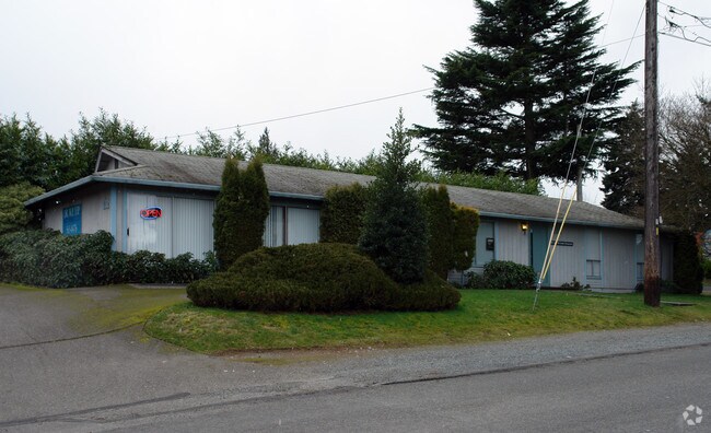
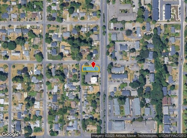
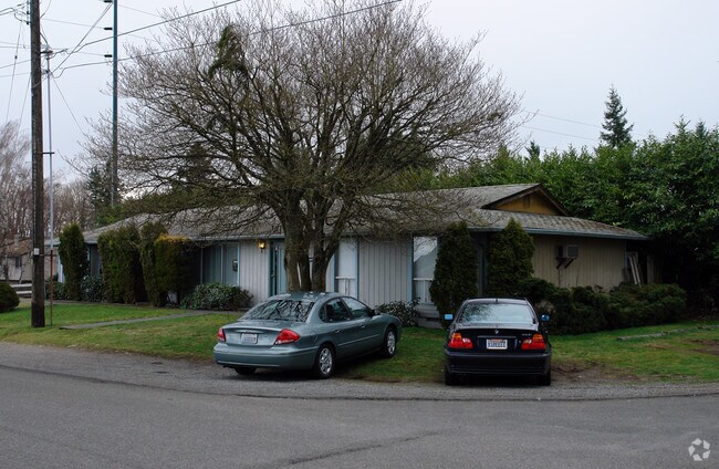
3102 Bridgeport Way W, University Place, WA 98466
NEARBY LISTINGS FOR SALE OR LEASE
Property Detail
3102 Bridgeport Way W
Seattle-Tacoma-Bellevue, WA
Menlo Park
578500-2620
SECTION 10 TOWNSHIP 20 RANGE 02 QUARTER 34 MENLO PARK: MENLO PARK SE OF SW 10-20-02E L 1 & 2 B 35 TOG/W 13 FT OF 14TH ST VAC EXC E 30 FT R/W CO RD ALSO EXC POR CYD FOR ADD R/W PER ETN 992885 APPROX 7,122 SQ FT DC 12/2/99 MA
Commercialnec
Pierce
X
Washington
53053C0281E
1
2024
0.16 AC
2025
Univ. Place/Lakewood
072310
Seattle/Puget Sound
1,824 SF
DEMOGRAPHICS near 3102 Bridgeport Way W
1 Mile
3 Mile
5 Mile
2024 Total Population
17,737
93,245
242,452
2029 Population
18,472
96,422
250,279
Pop Growth 2024-2029
+ 4.14%
+ 3.41%
+ 3.23%
Average Age
39
41
40
2024 Total Households
7,571
38,998
101,415
HH Growth 2024-2029
+ 4.21%
+ 3.55%
+ 3.43%
Median Household Inc
$78,455
$81,525
$78,721
Avg Household Size
2.30
2.30
2.30
2024 Avg HH Vehicles
2.00
2.00
2.00
Median Home Value
$593,822
$486,162
$474,897
Median Year Built
1978
1976
1972
Nearby Places
Map Layers
Map Styles
 Street
 Aerial
- Restaurants
- Banks
- Shops
- Fitness
- Groceries
PUBLIC TRANSPORTATION
COMMUTER RAIL
DRIVE
WALK
Distance
9 min
4.1 mi
DRIVE
WALK
Distance
16 min
6.8 mi
AIRPORT
Seattle-Tacoma International
DRIVE
WALK
Distance
Seattle-Tacoma International
44 min
27.2 mi
Freight Ports
Port of Tacoma
DRIVE
WALK
Distance
Port of Tacoma
17 min
8.8 mi
Nearby Properties
Address
Land Use
TOTAL SIZE
Lot Size
Zoning
Address
Land Use
TOTAL SIZE
Lot Size
Zoning
618,098 SF
150.67 AC
CCX
Address
Land Use
TOTAL SIZE
Lot Size
Zoning
87,528 SF
224.76 AC
R1
Address
Land Use
TOTAL SIZE
Lot Size
Zoning
412,549 SF
56.87 AC
R1
Address
Land Use
TOTAL SIZE
Lot Size
Zoning
309,156 SF
33.79 AC
M2
Address
Land Use
TOTAL SIZE
Lot Size
Zoning
335,336 SF
31.84 AC
RCX
Address
Land Use
TOTAL SIZE
Lot Size
Zoning
358,200 SF
27.25 AC
R3
Address
Land Use
TOTAL SIZE
Lot Size
Zoning
261,002 SF
28.34 AC
TAC
Address
Land Use
TOTAL SIZE
Lot Size
Zoning
196,380 SF
8.33 AC
R4L
Address
Land Use
TOTAL SIZE
Lot Size
Zoning
222,641 SF
15.41 AC
R4L
Address
Land Use
TOTAL SIZE
Lot Size
Zoning
8,177 SF
343.30 AC
R1
Address
Land Use
TOTAL SIZE
Lot Size
Zoning
100,856 SF
19.76 AC
R2
Address
Land Use
TOTAL SIZE
Lot Size
Zoning
149,844 SF
11.50 AC
MF
Address
Land Use
TOTAL SIZE
Lot Size
Zoning
223,447 SF
40.44 AC
RCX
Address
Land Use
TOTAL SIZE
Lot Size
Zoning
254,934 SF
5.02 AC
MF
Address
Land Use
TOTAL SIZE
Lot Size
Zoning
329,594 SF
10.60 AC
C2
Address
Land Use
TOTAL SIZE
Lot Size
Zoning
67,612 SF
2.93 AC
TAC
Address
Land Use
TOTAL SIZE
Lot Size
Zoning
208,780 SF
10.16 AC
R4L
Address
Land Use
TOTAL SIZE
Lot Size
Zoning
332,140 SF
9.23 AC
M2
Address
Land Use
TOTAL SIZE
Lot Size
Zoning
150,896 SF
11.63 AC
R3
Address
Land Use
TOTAL SIZE
Lot Size
Zoning
61.20 AC
M2
Address
Land Use
TOTAL SIZE
Lot Size
Zoning
117,608 SF
10.11 AC
R3
Address
Land Use
TOTAL SIZE
Lot Size
Zoning
119,926 SF
10.87 AC
HM
Address
Land Use
TOTAL SIZE
Lot Size
Zoning
109,674 SF
2.49 AC
R4L
Address
Land Use
TOTAL SIZE
Lot Size
Zoning
102,723 SF
16.16 AC
R4
Address
Land Use
TOTAL SIZE
Lot Size
Zoning
28,966 SF
101.94 AC
R2
Address
Land Use
TOTAL SIZE
Lot Size
Zoning
133,660 SF
6.79 AC
MF
Address
Land Use
TOTAL SIZE
Lot Size
Zoning
295,421 SF
15.92 AC
Address
Land Use
TOTAL SIZE
Lot Size
Zoning
187,937 SF
25 AC
C3
Address
Land Use
TOTAL SIZE
Lot Size
Zoning
213,345 SF
15.04 AC
R3
Address
Land Use
TOTAL SIZE
Lot Size
Zoning
156,548 SF
13.70 AC
CCX
The World's #1 Commercial Real Estate Marketplace
Connect with us
© 2025 CoStar Group
The information above has been obtained from sources believed reliable. While we do not doubt its accuracy we have not verified it and make no guarantee, warranty or representation about it. It is your responsibility to independently confirm its accuracy and completeness. Any projections, opinions, assumptions, or estimates used are for example only and do not represent the current or future performance of the property. The value of this transaction to you depends on tax and other factors which should be evaluated by your tax, financial, and legal advisors. You and your advisors should conduct a careful, independent investigation of the property to determine to your satisfaction the suitability of the property for your needs.