No Photo
Property Record
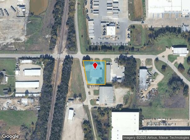
3102 Hale Rd, Ardmore, OK 73401
NEARBY LISTINGS FOR SALE OR LEASE
Property Detail
3102 Hale Rd
Ardmore, OK
Ardmore City Tracts
1990-07-05S-02E-3-008-00
BEG 1058.88 E & 40 S NW/C NW SW; S89.5726E 221; S00.5726E 260; W 170; N11.0826W 264.95 TO POB - 07 05S 02E
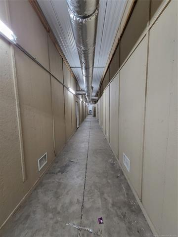
Warehouse
Carter
X
Oklahoma
40019C0445C
2e
2024
1.15 AC
2025
Oklahoma East Area
893100
Other Market Areas
14,760 SF
DEMOGRAPHICS near 3102 Hale Rd
1 Mile
3 Mile
5 Mile
2024 Total Population
128
12,811
28,659
2029 Population
132
13,204
29,531
Pop Growth 2024-2029
+ 3.13%
+ 3.07%
+ 3.04%
Average Age
40
41
40
2024 Total Households
47
5,029
11,377
HH Growth 2024-2029
+ 2.13%
+ 3.06%
+ 3.02%
Median Household Inc
$68,571
$49,680
$48,941
Avg Household Size
2.60
2.40
2.40
2024 Avg HH Vehicles
2.00
2.00
2.00
Median Home Value
$205,882
$158,252
$146,543
Median Year Built
1981
1965
1971
Nearby Places
Map Layers
Map Styles
 Street
 Aerial
- Restaurants
- Banks
- Shops
- Fitness
- Groceries
PUBLIC TRANSPORTATION
COMMUTER RAIL
Ardmore Amtrak Station (Heartland Flyer - Amtrak)
DRIVE
WALK
Distance
Ardmore Amtrak Station (Heartland Flyer - Amtrak)
7 min
3.9 mi
Freight Ports
Tulsa Port of Inola
DRIVE
WALK
Distance
Tulsa Port of Inola
241 min
207.9 mi
SALE & LEASE HISTORY
LISTING DATE
SALE/LEASE

Jul 17, 2018
For Sale
Apr 04, 2024
For Sale
Nearby Properties
Address
Land Use
TOTAL SIZE
Lot Size
Zoning
Address
Land Use
TOTAL SIZE
Lot Size
Zoning
1,020 SF
34.64 AC
C1
Address
Land Use
TOTAL SIZE
Lot Size
Zoning
828 SF
12.24 AC
C1
Address
Land Use
TOTAL SIZE
Lot Size
Zoning
3,188 SF
2.75 AC
C1
Address
Land Use
TOTAL SIZE
Lot Size
Zoning
1,479 SF
2.33 AC
C1
Address
Land Use
TOTAL SIZE
Lot Size
Zoning
7,560 SF
7.26 AC
C1
Address
Land Use
TOTAL SIZE
Lot Size
Zoning
3,078 SF
1.53 AC
C1
Address
Land Use
TOTAL SIZE
Lot Size
Zoning
5,889 SF
2.62 AC
C1
Address
Land Use
TOTAL SIZE
Lot Size
Zoning
3,150 SF
0.92 AC
C1
Address
Land Use
TOTAL SIZE
Lot Size
Zoning
36,800 SF
1.10 AC
C1
Address
Land Use
TOTAL SIZE
Lot Size
Zoning
444 SF
12.92 AC
C1
Address
Land Use
TOTAL SIZE
Lot Size
Zoning
3,294 SF
5.38 AC
C1
Address
Land Use
TOTAL SIZE
Lot Size
Zoning
3,125 SF
10 AC
C1
Address
Land Use
TOTAL SIZE
Lot Size
Zoning
1,000 SF
1.63 AC
C1
Address
Land Use
TOTAL SIZE
Lot Size
Zoning
2,500 SF
10 AC
C1
Address
Land Use
TOTAL SIZE
Lot Size
Zoning
6,664 SF
0.15 AC
C1
Address
Land Use
TOTAL SIZE
Lot Size
Zoning
5,588 SF
7.25 AC
C1
Address
Land Use
TOTAL SIZE
Lot Size
Zoning
3,985 SF
10 AC
C1
Address
Land Use
TOTAL SIZE
Lot Size
Zoning
336 SF
0.34 AC
C1
Address
Land Use
TOTAL SIZE
Lot Size
Zoning
5,840 SF
0.41 AC
C1
Address
Land Use
TOTAL SIZE
Lot Size
Zoning
55,440 SF
10.01 AC
C1
Address
Land Use
TOTAL SIZE
Lot Size
Zoning
3,972 SF
1.13 AC
C1
Address
Land Use
TOTAL SIZE
Lot Size
Zoning
2,282 SF
5 AC
R1
Address
Land Use
TOTAL SIZE
Lot Size
Zoning
888 SF
1.09 AC
C1
Address
Land Use
TOTAL SIZE
Lot Size
Zoning
980 SF
23.12 AC
C1
Address
Land Use
TOTAL SIZE
Lot Size
Zoning
732 SF
5.66 AC
C1
Address
Land Use
TOTAL SIZE
Lot Size
Zoning
7,436 SF
1.36 AC
C1
Address
Land Use
TOTAL SIZE
Lot Size
Zoning
281 SF
0.78 AC
C1
Address
Land Use
TOTAL SIZE
Lot Size
Zoning
136 SF
6 AC
C1
Address
Land Use
TOTAL SIZE
Lot Size
Zoning
5,246 SF
1.10 AC
Address
Land Use
TOTAL SIZE
Lot Size
Zoning
10,729 SF
1.33 AC
The World's #1 Commercial Real Estate Marketplace
Connect with us
© 2025 CoStar Group
The information above has been obtained from sources believed reliable. While we do not doubt its accuracy we have not verified it and make no guarantee, warranty or representation about it. It is your responsibility to independently confirm its accuracy and completeness. Any projections, opinions, assumptions, or estimates used are for example only and do not represent the current or future performance of the property. The value of this transaction to you depends on tax and other factors which should be evaluated by your tax, financial, and legal advisors. You and your advisors should conduct a careful, independent investigation of the property to determine to your satisfaction the suitability of the property for your needs.