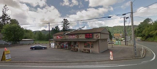
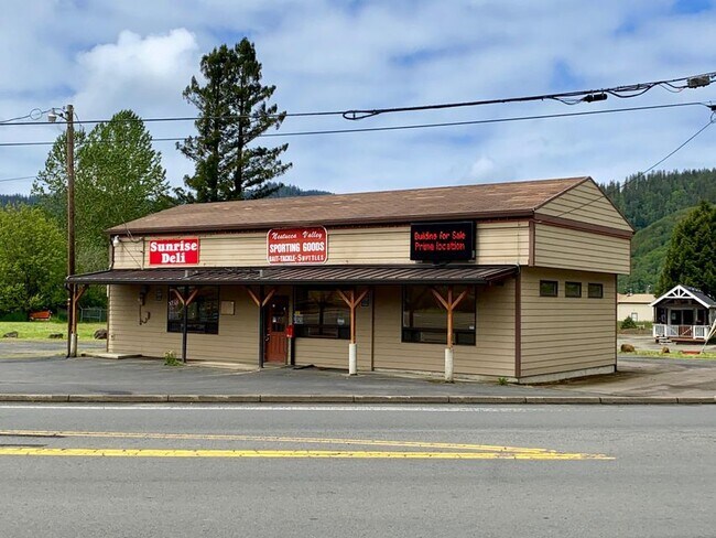
Property Record
31020 Highway 101 S, Hebo, OR 97122

Property Detail
31020 Highway 101 S
Commercialnec
Tillamook
C-2
Oregon
AE The base floodplain where base flood elevations are provided. AE Zones are now used on new format FIRMs instead of A1-A30 Zones.
0.31 AC
2025
Oregon West Area
2025
Other Market Areas
960800
R0033234
1,659 SF
NEARBY LISTINGS FOR SALE OR LEASE
-
-
View all Hebo listings for sale on LoopNet.com
DEMOGRAPHICS near 31020 Highway 101 S
1 mile
3 mile
5 mile
2024 Total Population
116
712
1,467
2029 Population
111
674
1,398
Pop Growth 2024-2029
(4.31%)
(5.34%)
(4.70%)
Average Age
45
44
45
2024 Total Households
47
282
596
HH Growth 2024-2029
(6.38%)
(6.03%)
(5.54%)
Median Household Inc
$47,999
$52,857
$51,020
Avg Household Size
2.40
2.40
2.40
2024 Avg HH Vehicles
3.00
3.00
3.00
Median Home Value
$383,333
$372,463
$384,523
Median Year Built
1977
1977
1978
Nearby Places
Map Layers
Map Styles
 Street
 Aerial
Transit
 Traffic
 Biking
Places
Listings with unknown addresses are not visible on the map
- Restaurants
- Banks
- Shops
- Fitness
- Groceries
SALE & LEASE HISTORY
LISTING DATE
SALE/LEASE

Oct 09, 2023
For Sale
Nov 23, 2022
For Sale
Nearby Properties
Address
Land Use
TOTAL SIZE
Lot Size
Zoning
Address
Land Use
TOTAL SIZE
Lot Size
Zoning
59,346 SF
9.64 AC
R1
Address
Land Use
TOTAL SIZE
Lot Size
Zoning
9,609 SF
14.15 AC
PUB
Address
Land Use
TOTAL SIZE
Lot Size
Zoning
1,320 SF
3.24 AC
CI
Address
Land Use
TOTAL SIZE
Lot Size
Zoning
7,184 SF
1.54 AC
PUB
Address
Land Use
TOTAL SIZE
Lot Size
Zoning
10 SF
0.71 AC
CP
Address
Land Use
TOTAL SIZE
Lot Size
Zoning
10 SF
2.49 AC
F
Address
Land Use
TOTAL SIZE
Lot Size
Zoning
9,584 SF
20.04 AC
SFW20
Address
Land Use
TOTAL SIZE
Lot Size
Zoning
59,824 SF
10.40 AC
F
Address
Land Use
TOTAL SIZE
Lot Size
Zoning
18,400 SF
1.28 AC
M-1
Address
Land Use
TOTAL SIZE
Lot Size
Zoning
4,765 SF
0.21 AC
R-3
Address
Land Use
TOTAL SIZE
Lot Size
Zoning
29,532 SF
5 AC
F-1
Address
Land Use
TOTAL SIZE
Lot Size
Zoning
11,150 SF
17 AC
F-1
Address
Land Use
TOTAL SIZE
Lot Size
Zoning
5,490 SF
0.28 AC
C-2
Address
Land Use
TOTAL SIZE
Lot Size
Zoning
4,430 SF
67 AC
F-1
Address
Land Use
TOTAL SIZE
Lot Size
Zoning
7,312 SF
1.31 AC
CI
Address
Land Use
TOTAL SIZE
Lot Size
Zoning
7,238 SF
38.32 AC
F-1
Address
Land Use
TOTAL SIZE
Lot Size
Zoning
5,390 SF
5.11 AC
CR-2,F
Address
Land Use
TOTAL SIZE
Lot Size
Zoning
3,434 SF
25.98 AC
F-1
Address
Land Use
TOTAL SIZE
Lot Size
Zoning
8,052 SF
35 AC
F-1
Address
Land Use
TOTAL SIZE
Lot Size
Zoning
7,960 SF
16.54 AC
F-1
Address
Land Use
TOTAL SIZE
Lot Size
Zoning
5,805 SF
45.75 AC
F-1
Address
Land Use
TOTAL SIZE
Lot Size
Zoning
2,244 SF
82.50 AC
F-1
Address
Land Use
TOTAL SIZE
Lot Size
Zoning
4,874 SF
33.99 AC
F,RR-2
Address
Land Use
TOTAL SIZE
Lot Size
Zoning
1,643 SF
0.22 AC
CI
Address
Land Use
TOTAL SIZE
Lot Size
Zoning
5,878 SF
27.27 AC
F-1
Address
Land Use
TOTAL SIZE
Lot Size
Zoning
11,200 SF
0.44 AC
M-1
Address
Land Use
TOTAL SIZE
Lot Size
Zoning
2,720 SF
124.81 AC
F-1
Address
Land Use
TOTAL SIZE
Lot Size
Zoning
2,952 SF
0.14 AC
R-3
Address
Land Use
TOTAL SIZE
Lot Size
Zoning
4,256 SF
0.34 AC
CC
Address
Land Use
TOTAL SIZE
Lot Size
Zoning
4,931 SF
16.53 AC
F-1
The World's #1 Commercial Real Estate Marketplace
Connect with us
© 2026 CoStar Group
The information above has been obtained from sources believed reliable. While we do not doubt its accuracy we have not verified it and make no guarantee, warranty or representation about it. It is your responsibility to independently confirm its accuracy and completeness. Any projections, opinions, assumptions, or estimates used are for example only and do not represent the current or future performance of the property. The value of this transaction to you depends on tax and other factors which should be evaluated by your tax, financial, and legal advisors. You and your advisors should conduct a careful, independent investigation of the property to determine to your satisfaction the suitability of the property for your needs.