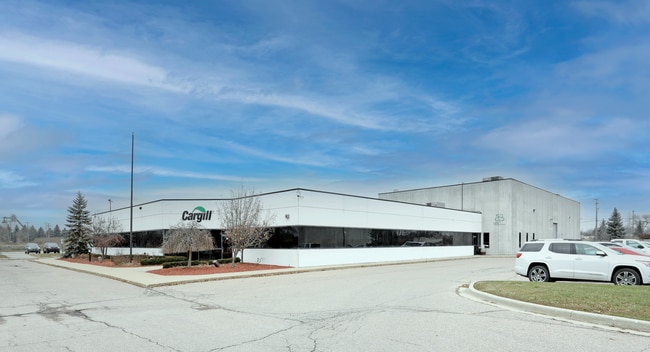
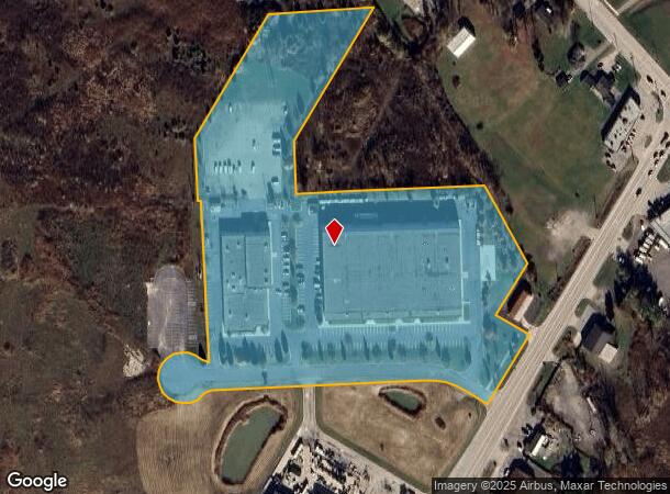
Property Record
31291 Comcast Dr, New Haven, MI 48048
Current Lease Availabilities
NEARBY LISTINGS FOR SALE OR LEASE
-
-
View all New Haven listings for lease on LoopNet.com
Property Detail
31291 Comcast Dr
26-06-33-403-001
Industrial Park
Industrialgeneral
CONDO NAME: MACOMB COUNTY CONDOMINIUM SUBDIVISION PLAN NO 618
X
Macomb
26099C0256G
Michigan
2025
5.66 AC
2025
St Clair & Lapeer Counties
218001
Detroit
88,116 SF
Detroit-Warren-Dearborn, MI
DEMOGRAPHICS near 31291 Comcast Dr
1 Mile
3 Mile
5 Mile
2024 Total Population
4,135
25,641
66,714
2029 Population
4,147
25,606
66,500
Pop Growth 2024-2029
+ 0.29%
(0.14%)
(0.32%)
Average Age
36
38
40
2024 Total Households
1,285
8,922
25,127
HH Growth 2024-2029
+ 0.23%
(0.12%)
(0.29%)
Median Household Inc
$63,821
$77,682
$78,571
Avg Household Size
2.90
2.70
2.50
2024 Avg HH Vehicles
2.00
2.00
2.00
Median Home Value
$188,271
$240,260
$251,964
Median Year Built
2002
1998
1994
Nearby Places
Map Layers
Map Styles
 Street
 Aerial
- Restaurants
- Banks
- Shops
- Fitness
- Groceries
Nearby Properties
Address
Land Use
TOTAL SIZE
Lot Size
Zoning
Address
Land Use
TOTAL SIZE
Lot Size
Zoning
115,695 SF
Address
Land Use
TOTAL SIZE
Lot Size
Zoning
459,100 SF
Address
Land Use
TOTAL SIZE
Lot Size
Zoning
316,907 SF
21.18 AC
M2 GEN
Address
Land Use
TOTAL SIZE
Lot Size
Zoning
210,688 SF
20.13 AC
CG
Address
Land Use
TOTAL SIZE
Lot Size
Zoning
179,250 SF
26.35 AC
M2 GEN
Address
Land Use
TOTAL SIZE
Lot Size
Zoning
7,262 SF
127.87 AC
MH
Address
Land Use
TOTAL SIZE
Lot Size
Zoning
5,541 SF
130.51 AC
MHP MO
Address
Land Use
TOTAL SIZE
Lot Size
Zoning
156,262 SF
16.23 AC
RM2 MU
Address
Land Use
TOTAL SIZE
Lot Size
Zoning
3,799 SF
56.46 AC
MH
Address
Land Use
TOTAL SIZE
Lot Size
Zoning
26,578 SF
31.52 AC
IR
Address
Land Use
TOTAL SIZE
Lot Size
Zoning
30,878 SF
5.32 AC
IO
Address
Land Use
TOTAL SIZE
Lot Size
Zoning
55,821 SF
M2 GEN
Address
Land Use
TOTAL SIZE
Lot Size
Zoning
15,788 SF
4.28 AC
CG
Address
Land Use
TOTAL SIZE
Lot Size
Zoning
58,392 SF
3.66 AC
M1 LIG
Address
Land Use
TOTAL SIZE
Lot Size
Zoning
82,370 SF
19.14 AC
M2 GEN
Address
Land Use
TOTAL SIZE
Lot Size
Zoning
19,280 SF
3.97 AC
M2 GEN
Address
Land Use
TOTAL SIZE
Lot Size
Zoning
85,097 SF
4.87 AC
M2 GEN
Address
Land Use
TOTAL SIZE
Lot Size
Zoning
21,944 SF
131.37 AC
CG
Address
Land Use
TOTAL SIZE
Lot Size
Zoning
18,905 SF
6.40 AC
RO
Address
Land Use
TOTAL SIZE
Lot Size
Zoning
3,418 SF
60 AC
CG
Address
Land Use
TOTAL SIZE
Lot Size
Zoning
32,476 SF
Address
Land Use
TOTAL SIZE
Lot Size
Zoning
3,927 SF
85.22 AC
MF
Address
Land Use
TOTAL SIZE
Lot Size
Zoning
26,578 SF
22.50 AC
Address
Land Use
TOTAL SIZE
Lot Size
Zoning
1,034 SF
36.86 AC
MHP MO
Address
Land Use
TOTAL SIZE
Lot Size
Zoning
20,434 SF
2.89 AC
SF II
Address
Land Use
TOTAL SIZE
Lot Size
Zoning
49,682 SF
6.31 AC
M2 GEN
Address
Land Use
TOTAL SIZE
Lot Size
Zoning
68,000 SF
10.54 AC
CC
Address
Land Use
TOTAL SIZE
Lot Size
Zoning
13,145 SF
4.05 AC
GB
Address
Land Use
TOTAL SIZE
Lot Size
Zoning
43.57 AC
M2 GEN
The World's #1 Commercial Real Estate Marketplace
Connect with us
© 2026 CoStar Group
The information above has been obtained from sources believed reliable. While we do not doubt its accuracy we have not verified it and make no guarantee, warranty or representation about it. It is your responsibility to independently confirm its accuracy and completeness. Any projections, opinions, assumptions, or estimates used are for example only and do not represent the current or future performance of the property. The value of this transaction to you depends on tax and other factors which should be evaluated by your tax, financial, and legal advisors. You and your advisors should conduct a careful, independent investigation of the property to determine to your satisfaction the suitability of the property for your needs.