Property Record
3103 Spring Grove Dr, Augusta, GA 30906
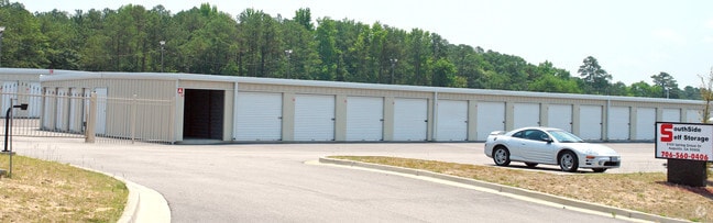

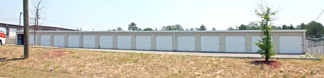

Property Detail
3103 Spring Grove Dr
0950223010
O DEANS BRIDGE RD
Commercialacreage
Richmond
B-2
Georgia
B and X Area of moderate flood hazard, usually the area between the limits of the 100-year and 500-year floods.
0
2025
4.09 AC
2025
South Richmond County
010512
Augusta/Richmond County
48,000 SF
Augusta-Richmond County, GA-SC
NEARBY LISTINGS FOR SALE OR LEASE
DEMOGRAPHICS near 3103 Spring Grove Dr
1 mile
3 mile
5 mile
2025 Total Population
6,538
43,873
127,045
2030 Population
6,361
43,479
127,153
Pop Growth 2025-2030
(2.71%)
(0.90%)
+ 0.09%
Average Age
39
38
38
2025 Total Households
2,278
16,750
48,230
HH Growth 2025-2030
(2.50%)
(0.81%)
+ 0.07%
Median Household Inc
$48,641
$48,289
$54,253
Avg Household Size
2.80
2.60
2.40
2025 Avg HH Vehicles
2.00
2.00
2.00
Median Home Value
$143,179
$158,286
$186,171
Median Year Built
1976
1976
1980
Nearby Places
Map Layers
Map Styles
 Street
 Aerial
Layers
 Traffic
 Biking
Places
Listings with unknown addresses are not visible on the map
- Restaurants
- Banks
- Shops
- Fitness
- Groceries
PUBLIC TRANSPORTATION
AIRPORT
Augusta Regional at Bush Field
Drive
Walk
Distance
Augusta Regional at Bush Field
17 min
8.5 mi
Freight Ports
Georgia Ports - Savannah
Drive
Walk
Distance
Georgia Ports - Savannah
151 min
117.6 mi
Nearby Properties
Address
Land Use
TOTAL SIZE
Lot Size
Zoning
Address
Land Use
TOTAL SIZE
Lot Size
Zoning
292,232 SF
39.73 AC
B-2
Address
Land Use
TOTAL SIZE
Lot Size
Zoning
984 SF
16.18 AC
R-3C
Address
Land Use
TOTAL SIZE
Lot Size
Zoning
1,428 SF
75.91 AC
R-1A
Address
Land Use
TOTAL SIZE
Lot Size
Zoning
36,755 SF
12.09 AC
B-2
Address
Land Use
TOTAL SIZE
Lot Size
Zoning
1,620 SF
21.51 AC
R-3B
Address
Land Use
TOTAL SIZE
Lot Size
Zoning
99,046 SF
29.96 AC
R-1A
Address
Land Use
TOTAL SIZE
Lot Size
Zoning
241,284 SF
20.61 AC
R-1A
Address
Land Use
TOTAL SIZE
Lot Size
Zoning
56,631 SF
11.62 AC
R-1A, B-2
Address
Land Use
TOTAL SIZE
Lot Size
Zoning
4,196 SF
30.70 AC
R-3A
Address
Land Use
TOTAL SIZE
Lot Size
Zoning
4,947 SF
71.24 AC
R-3B
Address
Land Use
TOTAL SIZE
Lot Size
Zoning
16,120 SF
21.38 AC
R-3A
Address
Land Use
TOTAL SIZE
Lot Size
Zoning
158,192 SF
48.91 AC
R-1A
Address
Land Use
TOTAL SIZE
Lot Size
Zoning
193,478 SF
24.91 AC
B-2
Address
Land Use
TOTAL SIZE
Lot Size
Zoning
24,304 SF
11 AC
R-1A
Address
Land Use
TOTAL SIZE
Lot Size
Zoning
40,824 SF
9.49 AC
R-3B
Address
Land Use
TOTAL SIZE
Lot Size
Zoning
94,579 SF
60.10 AC
R-1
Address
Land Use
TOTAL SIZE
Lot Size
Zoning
5,636 SF
32.26 AC
B-2
Address
Land Use
TOTAL SIZE
Lot Size
Zoning
67,713 SF
5.24 AC
LI
Address
Land Use
TOTAL SIZE
Lot Size
Zoning
16,790 SF
22.07 AC
B-2
Address
Land Use
TOTAL SIZE
Lot Size
Zoning
700 SF
7.12 AC
R-3C
Address
Land Use
TOTAL SIZE
Lot Size
Zoning
29,952 SF
13.76 AC
R-3B_B-2
Address
Land Use
TOTAL SIZE
Lot Size
Zoning
41,664 SF
12.52 AC
R-3A
Address
Land Use
TOTAL SIZE
Lot Size
Zoning
22,080 SF
19.49 AC
R-3B
Address
Land Use
TOTAL SIZE
Lot Size
Zoning
57,408 SF
7.20 AC
R-3B
Address
Land Use
TOTAL SIZE
Lot Size
Zoning
2,040 SF
18.66 AC
R-1C SPEX
Address
Land Use
TOTAL SIZE
Lot Size
Zoning
1,936 SF
13.39 AC
B-1
Address
Land Use
TOTAL SIZE
Lot Size
Zoning
38,911 SF
4.46 AC
LI_A
Address
Land Use
TOTAL SIZE
Lot Size
Zoning
107,996 SF
9.91 AC
R-3B
Address
Land Use
TOTAL SIZE
Lot Size
Zoning
160,141 SF
10.17 AC
B-2
Address
Land Use
TOTAL SIZE
Lot Size
Zoning
75,160 SF
8.55 AC
B-2
The World's #1 Commercial Real Estate Marketplace
Connect with us
© 2026 CoStar Group
The information above has been obtained from sources believed reliable. While we do not doubt its accuracy we have not verified it and make no guarantee, warranty or representation about it. It is your responsibility to independently confirm its accuracy and completeness. Any projections, opinions, assumptions, or estimates used are for example only and do not represent the current or future performance of the property. The value of this transaction to you depends on tax and other factors which should be evaluated by your tax, financial, and legal advisors. You and your advisors should conduct a careful, independent investigation of the property to determine to your satisfaction the suitability of the property for your needs.