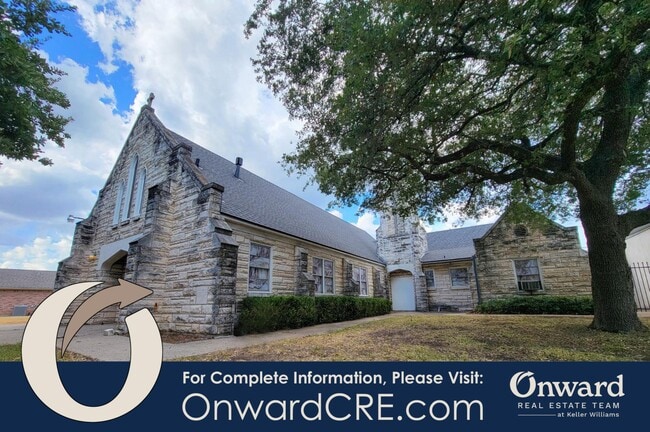
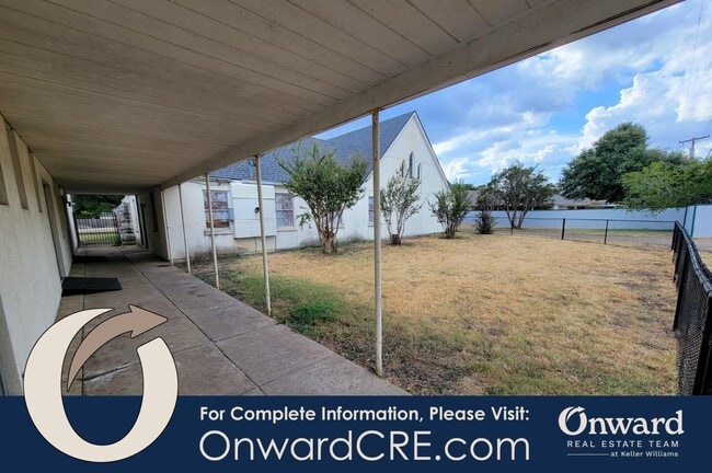
Property Record
3109 Macarthur Dr, Waco, TX 76708
Property Detail
3109 Macarthur Dr
Waco, TX
CHRIST LUTHERAN LOT 8 BLOCK A ACRES 1.677
48-009008-000800-0
MCLENNAN
Commercialnec
Texas
0
8
2025
1.68 AC
002800
Waco
9,650 SF
Other Market Areas
NEARBY LISTINGS FOR SALE OR LEASE
-
-
View all Waco listings for sale on LoopNet.com
DEMOGRAPHICS near 3109 Macarthur Dr
1 mile
3 mile
5 mile
2024 Total Population
11,846
60,774
125,284
2029 Population
12,450
64,271
133,675
Pop Growth 2024-2029
+ 5.10%
+ 5.75%
+ 6.70%
Average Age
38
37
35
2024 Total Households
4,689
23,959
47,547
HH Growth 2024-2029
+ 5.20%
+ 5.84%
+ 7.06%
Median Household Inc
$48,820
$44,302
$42,974
Avg Household Size
2.40
2.40
2.40
2024 Avg HH Vehicles
2.00
2.00
2.00
Median Home Value
$169,944
$159,007
$151,804
Median Year Built
1966
1964
1972
Nearby Places
Map Layers
Map Styles
 Street
 Aerial
Transit
 Traffic
 Biking
Places
Listings with unknown addresses are not visible on the map
- Restaurants
- Banks
- Shops
- Fitness
- Groceries
PUBLIC TRANSPORTATION
AIRPORT
Waco Regional
Drive
Walk
Distance
Waco Regional
14 min
5.4 mi
Freight Ports
Port of Houston
Drive
Walk
Distance
Port of Houston
222 min
190.1 mi
SALE & LEASE HISTORY
LISTING DATE
SALE/LEASE

Aug 30, 2024
For Sale
Nearby Properties
Address
Land Use
TOTAL SIZE
Lot Size
Zoning
Address
Land Use
TOTAL SIZE
Lot Size
Zoning
452,498 SF
39.43 AC
C-2
Address
Land Use
TOTAL SIZE
Lot Size
Zoning
10,334 SF
29.45 AC
R1B
Address
Land Use
TOTAL SIZE
Lot Size
Zoning
214,351 SF
19.37 AC
R3B
Address
Land Use
TOTAL SIZE
Lot Size
Zoning
186,924 SF
9.14 AC
O-2
Address
Land Use
TOTAL SIZE
Lot Size
Zoning
181,423 SF
16.03 AC
R1B
Address
Land Use
TOTAL SIZE
Lot Size
Zoning
189,996 SF
13.98 AC
O2
Address
Land Use
TOTAL SIZE
Lot Size
Zoning
167,206 SF
11.22 AC
R-3C
Address
Land Use
TOTAL SIZE
Lot Size
Zoning
238,580 SF
12.25 AC
R-3E
Address
Land Use
TOTAL SIZE
Lot Size
Zoning
228,638 SF
14.56 AC
O-2
Address
Land Use
TOTAL SIZE
Lot Size
Zoning
205,184 SF
18.71 AC
R3D
Address
Land Use
TOTAL SIZE
Lot Size
Zoning
32,870 SF
100 AC
TIF3
Address
Land Use
TOTAL SIZE
Lot Size
Zoning
111,840 SF
38.94 AC
R1B
Address
Land Use
TOTAL SIZE
Lot Size
Zoning
158,050 SF
17.19 AC
R-2
Address
Land Use
TOTAL SIZE
Lot Size
Zoning
137,233 SF
3.51 AC
O2
Address
Land Use
TOTAL SIZE
Lot Size
Zoning
203,384 SF
16.28 AC
C-2
Address
Land Use
TOTAL SIZE
Lot Size
Zoning
50,570 SF
6.25 AC
2007 TIF
Address
Land Use
TOTAL SIZE
Lot Size
Zoning
102,910 SF
6.38 AC
TIF2
Address
Land Use
TOTAL SIZE
Lot Size
Zoning
93,623 SF
4.26 AC
C2
Address
Land Use
TOTAL SIZE
Lot Size
Zoning
143,780 SF
10.07 AC
C-3
Address
Land Use
TOTAL SIZE
Lot Size
Zoning
226,099 SF
97.28 AC
Address
Land Use
TOTAL SIZE
Lot Size
Zoning
61,752 SF
3.68 AC
C2
Address
Land Use
TOTAL SIZE
Lot Size
Zoning
95,432 SF
16.54 AC
C3
Address
Land Use
TOTAL SIZE
Lot Size
Zoning
79,440 SF
0.97 AC
2007 TIF
Address
Land Use
TOTAL SIZE
Lot Size
Zoning
249,114 SF
14.46 AC
C2
Address
Land Use
TOTAL SIZE
Lot Size
Zoning
159,356 SF
14.08 AC
C3
Address
Land Use
TOTAL SIZE
Lot Size
Zoning
58,414 SF
0.46 AC
2007 TIF
Address
Land Use
TOTAL SIZE
Lot Size
Zoning
127,586 SF
12.78 AC
R-3B
Address
Land Use
TOTAL SIZE
Lot Size
Zoning
3.12 AC
R3D
Address
Land Use
TOTAL SIZE
Lot Size
Zoning
4.26 AC
2007 TIF
Address
Land Use
TOTAL SIZE
Lot Size
Zoning
11,487 SF
85.25 AC
R
The World's #1 Commercial Real Estate Marketplace
Connect with us
© 2026 CoStar Group
The information above has been obtained from sources believed reliable. While we do not doubt its accuracy we have not verified it and make no guarantee, warranty or representation about it. It is your responsibility to independently confirm its accuracy and completeness. Any projections, opinions, assumptions, or estimates used are for example only and do not represent the current or future performance of the property. The value of this transaction to you depends on tax and other factors which should be evaluated by your tax, financial, and legal advisors. You and your advisors should conduct a careful, independent investigation of the property to determine to your satisfaction the suitability of the property for your needs.