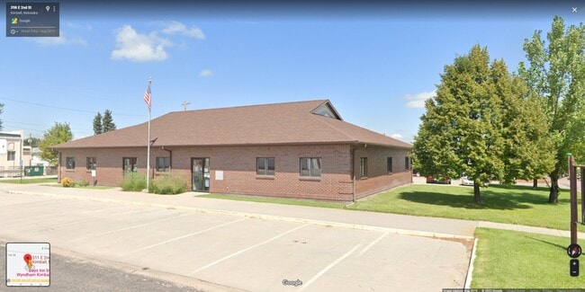
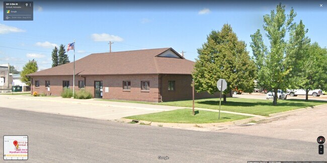
Property Record
311 E 2Nd St, Kimball, NE 69145

Property Detail
311 E 2Nd St
530047136
ANTELOPEVILLE ADD. BLOCK 5 LOTS 11A AND 12A (CARD #59) 311 EAST 2ND STREET
Officebuilding
KIMBALL
03-COMMERC
Nebraska
2025
11a
2025
0.64 AC
954500
I-80 Corridor
4,368 SF
Other Market Areas
NEARBY LISTINGS FOR SALE OR LEASE
-
-
View all Kimball listings for sale on LoopNet.com
DEMOGRAPHICS near 311 E 2Nd St
1 mile
3 mile
5 mile
2025 Total Population
2,277
2,470
2,538
2030 Population
2,225
2,414
2,479
Pop Growth 2025-2030
(2.28%)
(2.27%)
(2.32%)
Average Age
45
45
45
2025 Total Households
1,001
1,084
1,113
HH Growth 2025-2030
(2.40%)
(2.40%)
(2.43%)
Median Household Inc
$59,883
$59,893
$60,043
Avg Household Size
2.20
2.20
2.20
2025 Avg HH Vehicles
2.00
2.00
2.00
Median Home Value
$118,905
$119,815
$121,493
Median Year Built
1955
1955
1955
Nearby Places
Map Layers
Map Styles
 Street
 Aerial
Transit
 Traffic
 Biking
Places
Listings with unknown addresses are not visible on the map
- Restaurants
- Banks
- Shops
- Fitness
- Groceries
SALE & LEASE HISTORY
LISTING DATE
SALE/LEASE

Aug 15, 2022
For Sale
Nearby Properties
Address
Land Use
TOTAL SIZE
Lot Size
Zoning
Address
Land Use
TOTAL SIZE
Lot Size
Zoning
66,960 SF
35.17 AC
04-INDUSTR
Address
Land Use
TOTAL SIZE
Lot Size
Zoning
26,775 SF
25.18 AC
04-INDUSTR
Address
Land Use
TOTAL SIZE
Lot Size
Zoning
18,375 SF
11.97 AC
01-SINGLE
Address
Land Use
TOTAL SIZE
Lot Size
Zoning
41,950 SF
3.29 AC
01-SINGLE
Address
Land Use
TOTAL SIZE
Lot Size
Zoning
4,560 SF
1.37 AC
01-SINGLE
Address
Land Use
TOTAL SIZE
Lot Size
Zoning
27,125 SF
3.11 AC
01-SINGLE
Address
Land Use
TOTAL SIZE
Lot Size
Zoning
26,189 SF
2.32 AC
03-COMMERC
Address
Land Use
TOTAL SIZE
Lot Size
Zoning
27,837 SF
3.93 AC
01-SINGLE
Address
Land Use
TOTAL SIZE
Lot Size
Zoning
21,835 SF
1.62 AC
03-COMMERC
Address
Land Use
TOTAL SIZE
Lot Size
Zoning
15,620 SF
19.89 AC
01-SINGLE
Address
Land Use
TOTAL SIZE
Lot Size
Zoning
24,254 SF
0.90 AC
01-SINGLE
Address
Land Use
TOTAL SIZE
Lot Size
Zoning
21,240 SF
4.35 AC
03-COMMERC
Address
Land Use
TOTAL SIZE
Lot Size
Zoning
12,624 SF
2.80 AC
03-COMMERC
Address
Land Use
TOTAL SIZE
Lot Size
Zoning
10,580 SF
1.40 AC
03-COMMERC
Address
Land Use
TOTAL SIZE
Lot Size
Zoning
20,754 SF
0.64 AC
03-COMMERC
Address
Land Use
TOTAL SIZE
Lot Size
Zoning
16,996 SF
0.27 AC
03-COMMERC
Address
Land Use
TOTAL SIZE
Lot Size
Zoning
5,184 SF
4 AC
03-COMMERC
Address
Land Use
TOTAL SIZE
Lot Size
Zoning
10,454 SF
0.24 AC
03-COMMERC
Address
Land Use
TOTAL SIZE
Lot Size
Zoning
8,000 SF
6.80 AC
Address
Land Use
TOTAL SIZE
Lot Size
Zoning
12,630 SF
1.06 AC
03-COMMERC
Address
Land Use
TOTAL SIZE
Lot Size
Zoning
2,510 SF
1.37 AC
01-SINGLE
Address
Land Use
TOTAL SIZE
Lot Size
Zoning
17,949 SF
1.02 AC
03-COMMERC
Address
Land Use
TOTAL SIZE
Lot Size
Zoning
2,880 SF
1.53 AC
01-SINGLE
Address
Land Use
TOTAL SIZE
Lot Size
Zoning
340.93 AC
Address
Land Use
TOTAL SIZE
Lot Size
Zoning
25,200 SF
4.89 AC
01-SINGLE
Address
Land Use
TOTAL SIZE
Lot Size
Zoning
9,400 SF
8.65 AC
04-INDUSTR
Address
Land Use
TOTAL SIZE
Lot Size
Zoning
4,000 SF
2.31 AC
03-COMMERC
Address
Land Use
TOTAL SIZE
Lot Size
Zoning
10,659 SF
0.24 AC
03-COMMERC
Address
Land Use
TOTAL SIZE
Lot Size
Zoning
5,995 SF
10.87 AC
07-OTHER
The World's #1 Commercial Real Estate Marketplace
Connect with us
© 2026 CoStar Group
The information above has been obtained from sources believed reliable. While we do not doubt its accuracy we have not verified it and make no guarantee, warranty or representation about it. It is your responsibility to independently confirm its accuracy and completeness. Any projections, opinions, assumptions, or estimates used are for example only and do not represent the current or future performance of the property. The value of this transaction to you depends on tax and other factors which should be evaluated by your tax, financial, and legal advisors. You and your advisors should conduct a careful, independent investigation of the property to determine to your satisfaction the suitability of the property for your needs.