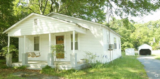
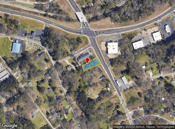
Property Record
311 Harbins Rd, Dacula, GA 30019
NEARBY LISTINGS FOR SALE OR LEASE
-
-
View all Dacula listings for lease on LoopNet.com
Property Detail
311 Harbins Rd
Atlanta-Sandy Springs-Roswell, GA
Kenneth A Wilber Surv
5-301-018
MONROE AVE
Commercialacreage
Gwinnett
X
Georgia
13135C0062G
301
2025
0.31 AC
2025
Lawrenceville/Lilburn
050622
Atlanta
1,036 SF
DEMOGRAPHICS near 311 Harbins Rd
1 Mile
3 Mile
5 Mile
2024 Total Population
3,828
37,202
114,089
2029 Population
4,067
39,580
120,918
Pop Growth 2024-2029
+ 6.24%
+ 6.39%
+ 5.99%
Average Age
37
36
37
2024 Total Households
1,230
11,152
34,200
HH Growth 2024-2029
+ 6.34%
+ 6.48%
+ 6.26%
Median Household Inc
$71,183
$98,126
$90,739
Avg Household Size
3.10
3.30
3.20
2024 Avg HH Vehicles
2.00
2.00
2.00
Median Home Value
$234,827
$288,308
$300,677
Median Year Built
1990
2005
2002
Nearby Places
Map Layers
Map Styles
 Street
 Aerial
- Restaurants
- Banks
- Shops
- Fitness
- Groceries
SALE & LEASE HISTORY
LISTING DATE
SALE/LEASE

Oct 20, 2016
For Lease
Aug 25, 2020
For Lease
Nearby Properties
Address
Land Use
TOTAL SIZE
Lot Size
Zoning
Address
Land Use
TOTAL SIZE
Lot Size
Zoning
2,260,742 SF
285.40 AC
M1
Address
Land Use
TOTAL SIZE
Lot Size
Zoning
250,960 SF
17.55 AC
OI
Address
Land Use
TOTAL SIZE
Lot Size
Zoning
101,343 SF
44.33 AC
R1400
Address
Land Use
TOTAL SIZE
Lot Size
Zoning
204,895 SF
26.89 AC
R1200
Address
Land Use
TOTAL SIZE
Lot Size
Zoning
149,440 SF
28.41 AC
M1
Address
Land Use
TOTAL SIZE
Lot Size
Zoning
178,635 SF
28.77 AC
R1200
Address
Land Use
TOTAL SIZE
Lot Size
Zoning
140,809 SF
8.97 AC
RM13
Address
Land Use
TOTAL SIZE
Lot Size
Zoning
327,884 SF
19 AC
M1
Address
Land Use
TOTAL SIZE
Lot Size
Zoning
160,446 SF
12 AC
GOV
Address
Land Use
TOTAL SIZE
Lot Size
Zoning
61,686 SF
10 AC
R1400
Address
Land Use
TOTAL SIZE
Lot Size
Zoning
102,618 SF
18 AC
R1200
Address
Land Use
TOTAL SIZE
Lot Size
Zoning
4,588 SF
109.24 AC
RZT
Address
Land Use
TOTAL SIZE
Lot Size
Zoning
143,845 SF
31.36 AC
RA200
Address
Land Use
TOTAL SIZE
Lot Size
Zoning
99,516 SF
10.83 AC
C3
Address
Land Use
TOTAL SIZE
Lot Size
Zoning
73.79 AC
RZT
Address
Land Use
TOTAL SIZE
Lot Size
Zoning
110,540 SF
22.94 AC
M1
Address
Land Use
TOTAL SIZE
Lot Size
Zoning
47,141 SF
8.29 AC
AG
Address
Land Use
TOTAL SIZE
Lot Size
Zoning
70,345 SF
10.51 AC
PMUD
Address
Land Use
TOTAL SIZE
Lot Size
Zoning
104.38 AC
MUR
Address
Land Use
TOTAL SIZE
Lot Size
Zoning
86,111 SF
16.03 AC
C2
Address
Land Use
TOTAL SIZE
Lot Size
Zoning
164,442 SF
18 AC
C2
Address
Land Use
TOTAL SIZE
Lot Size
Zoning
69,901 SF
10.01 AC
C2
Address
Land Use
TOTAL SIZE
Lot Size
Zoning
150,600 SF
11.82 AC
M1
Address
Land Use
TOTAL SIZE
Lot Size
Zoning
11,324 SF
25 AC
R1200
Address
Land Use
TOTAL SIZE
Lot Size
Zoning
149,540 SF
16.37 AC
M1
Address
Land Use
TOTAL SIZE
Lot Size
Zoning
70.45 AC
R1400
Address
Land Use
TOTAL SIZE
Lot Size
Zoning
26.69 AC
R100
Address
Land Use
TOTAL SIZE
Lot Size
Zoning
1,000 SF
25 AC
R1200
Address
Land Use
TOTAL SIZE
Lot Size
Zoning
16,445 SF
14.22 AC
RA200
Address
Land Use
TOTAL SIZE
Lot Size
Zoning
101,285 SF
10.49 AC
M1
The World's #1 Commercial Real Estate Marketplace
Connect with us
© 2026 CoStar Group
The information above has been obtained from sources believed reliable. While we do not doubt its accuracy we have not verified it and make no guarantee, warranty or representation about it. It is your responsibility to independently confirm its accuracy and completeness. Any projections, opinions, assumptions, or estimates used are for example only and do not represent the current or future performance of the property. The value of this transaction to you depends on tax and other factors which should be evaluated by your tax, financial, and legal advisors. You and your advisors should conduct a careful, independent investigation of the property to determine to your satisfaction the suitability of the property for your needs.