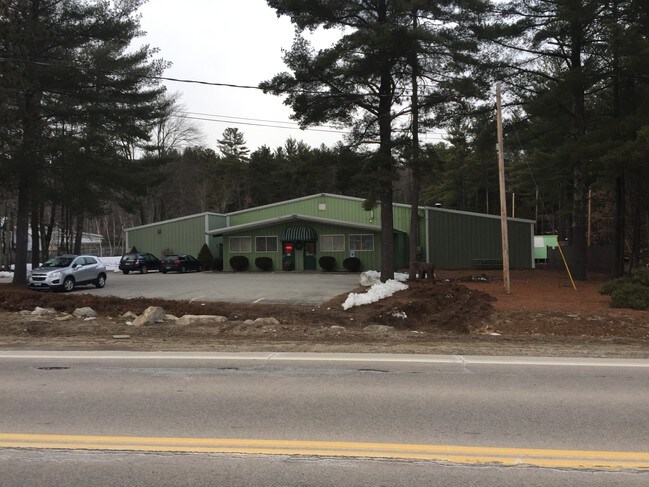
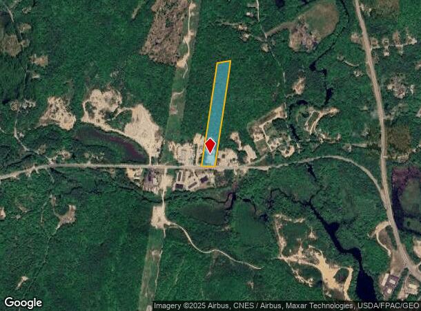
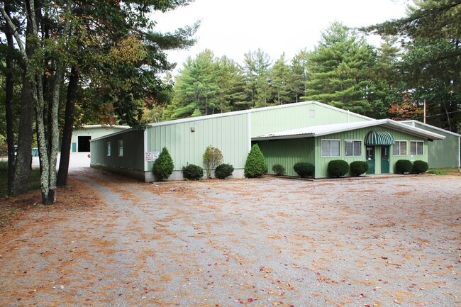
Property Record
311 Route 27, Raymond, NH 03077
NEARBY LISTINGS FOR SALE OR LEASE
Property Detail
311 Route 27
RAYM-000037-000000-000014
Rockingham
Commercialnec
New Hampshire
X
14
33015C0178E
15 AC
2024
Rockingham
2024
Boston
055001
Boston-Cambridge-Newton, MA-NH
12,420 SF
DEMOGRAPHICS near 311 Route 27
1 Mile
3 Mile
5 Mile
2024 Total Population
779
5,841
15,190
2029 Population
810
6,086
15,767
Pop Growth 2024-2029
+ 3.98%
+ 4.19%
+ 3.80%
Average Age
43
44
43
2024 Total Households
319
2,349
5,902
HH Growth 2024-2029
+ 3.76%
+ 4.21%
+ 3.78%
Median Household Inc
$96,249
$103,032
$104,252
Avg Household Size
2.40
2.50
2.50
2024 Avg HH Vehicles
2.00
2.00
2.00
Median Home Value
$335,500
$320,760
$341,666
Median Year Built
1979
1978
1981
Nearby Places
Map Layers
Map Styles
 Street
 Aerial
- Restaurants
- Banks
- Shops
- Fitness
- Groceries
PUBLIC TRANSPORTATION
AIRPORT
Manchester Boston Regional
DRIVE
WALK
Distance
Manchester Boston Regional
32 min
18.7 mi
Portsmouth International at Pease
DRIVE
WALK
Distance
Portsmouth International at Pease
49 min
30.1 mi
Freight Ports
Port of Boston
DRIVE
WALK
Distance
Port of Boston
94 min
62.7 mi
SALE & LEASE HISTORY
LISTING DATE
SALE/LEASE

Oct 19, 2017
For Lease
Oct 19, 2017
For Sale
Mar 06, 2017
For Lease
Jun 12, 2017
For Sale
Nearby Properties
Address
Land Use
TOTAL SIZE
Lot Size
Zoning
Address
Land Use
TOTAL SIZE
Lot Size
Zoning
3,030 SF
139 AC
AR AGR
Address
Land Use
TOTAL SIZE
Lot Size
Zoning
45,952 SF
16.07 AC
5
Address
Land Use
TOTAL SIZE
Lot Size
Zoning
54,154 SF
14 AC
A
Address
Land Use
TOTAL SIZE
Lot Size
Zoning
12,974 SF
8.50 AC
C1
Address
Land Use
TOTAL SIZE
Lot Size
Zoning
936 SF
89 AC
C1
Address
Land Use
TOTAL SIZE
Lot Size
Zoning
8.62 AC
C1
Address
Land Use
TOTAL SIZE
Lot Size
Zoning
10,069 SF
4.50 AC
C1
Address
Land Use
TOTAL SIZE
Lot Size
Zoning
23,340 SF
9 AC
C1
Address
Land Use
TOTAL SIZE
Lot Size
Zoning
1,920 SF
9.34 AC
C1
Address
Land Use
TOTAL SIZE
Lot Size
Zoning
4,000 SF
19.39 AC
C1
Address
Land Use
TOTAL SIZE
Lot Size
Zoning
25.25 AC
B
Address
Land Use
TOTAL SIZE
Lot Size
Zoning
3,450 SF
78.56 AC
B
Address
Land Use
TOTAL SIZE
Lot Size
Zoning
3.30 AC
2
Address
Land Use
TOTAL SIZE
Lot Size
Zoning
15,099 SF
3.74 AC
C1
Address
Land Use
TOTAL SIZE
Lot Size
Zoning
16,416 SF
3.70 AC
A
Address
Land Use
TOTAL SIZE
Lot Size
Zoning
1,500 SF
180 AC
B
Address
Land Use
TOTAL SIZE
Lot Size
Zoning
42.49 AC
3
Address
Land Use
TOTAL SIZE
Lot Size
Zoning
11.23 AC
1
Address
Land Use
TOTAL SIZE
Lot Size
Zoning
13,481 SF
3 AC
AR AGR
Address
Land Use
TOTAL SIZE
Lot Size
Zoning
21.62 AC
2
Address
Land Use
TOTAL SIZE
Lot Size
Zoning
14,736 SF
13.45 AC
1
Address
Land Use
TOTAL SIZE
Lot Size
Zoning
9,950 SF
2.53 AC
2
Address
Land Use
TOTAL SIZE
Lot Size
Zoning
8,528 SF
5.14 AC
2
Address
Land Use
TOTAL SIZE
Lot Size
Zoning
3,734 SF
0.64 AC
5
Address
Land Use
TOTAL SIZE
Lot Size
Zoning
26,386 SF
5.47 AC
3
Address
Land Use
TOTAL SIZE
Lot Size
Zoning
6,731 SF
9.14 AC
5
Address
Land Use
TOTAL SIZE
Lot Size
Zoning
18,884 SF
45.17 AC
1
Address
Land Use
TOTAL SIZE
Lot Size
Zoning
1,720 SF
5.13 AC
2
Address
Land Use
TOTAL SIZE
Lot Size
Zoning
9,216 SF
4.70 AC
C1
Address
Land Use
TOTAL SIZE
Lot Size
Zoning
6,370 SF
3.95 AC
1
The World's #1 Commercial Real Estate Marketplace
Connect with us
© 2025 CoStar Group
The information above has been obtained from sources believed reliable. While we do not doubt its accuracy we have not verified it and make no guarantee, warranty or representation about it. It is your responsibility to independently confirm its accuracy and completeness. Any projections, opinions, assumptions, or estimates used are for example only and do not represent the current or future performance of the property. The value of this transaction to you depends on tax and other factors which should be evaluated by your tax, financial, and legal advisors. You and your advisors should conduct a careful, independent investigation of the property to determine to your satisfaction the suitability of the property for your needs.