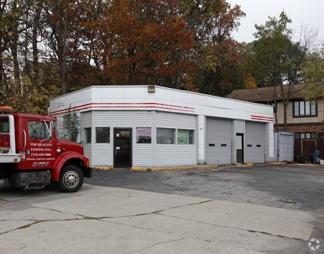
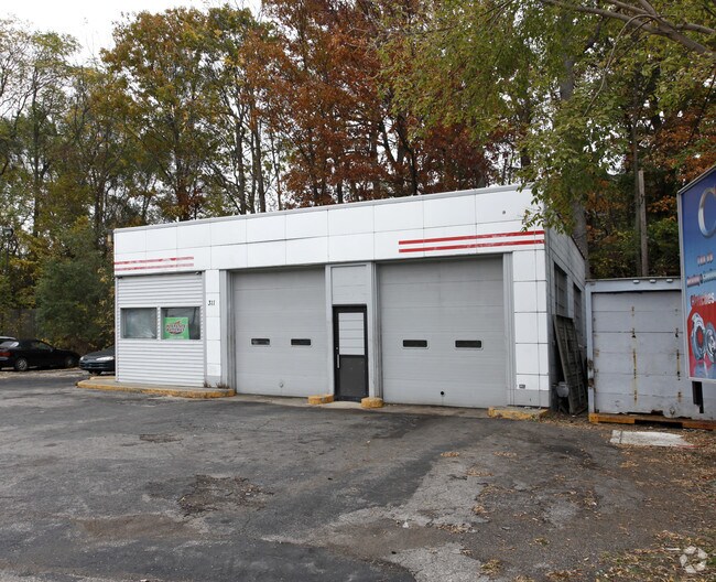
Property Record
311 S Grove St, Ypsilanti, MI 48198
NEARBY LISTINGS FOR SALE OR LEASE
Property Detail
311 S Grove St
Ann Arbor, MI
Ft To Pob Hunters Add
11-09-496-002
BNDRY ADJST PER QCD 05/16/2016 YP CITY 16E-116 PT OF LOTS 101 & 102 & FACTORY STREET. LAND COM AT SE COR FACTORY & GROVE STREETS, TH S'LY 157.62 FT, TH N 88 DEG 43' E 80.00 FT, TH N'LY PAR TO E LINE GROVE ST. 79.75 FT TO S LINE LOT 101, TH E'LY 20 1/
Commercialnec
Washtenaw
X
Michigan
26161C0426E
101-102
2025
0.34 AC
2025
Washtenaw E of 23
410800
Detroit
1,389 SF
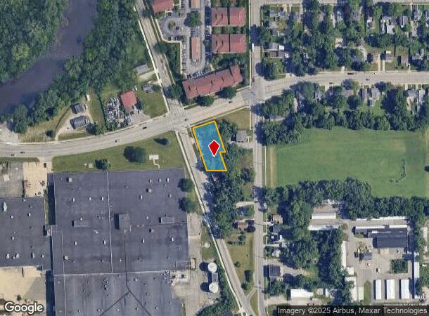
DEMOGRAPHICS near 311 S Grove St
1 Mile
3 Mile
5 Mile
2024 Total Population
9,163
66,471
118,732
2029 Population
9,077
65,764
117,318
Pop Growth 2024-2029
(0.94%)
(1.06%)
(1.19%)
Average Age
40
37
37
2024 Total Households
4,428
28,042
49,995
HH Growth 2024-2029
(1.04%)
(1.21%)
(1.34%)
Median Household Inc
$43,176
$52,204
$58,397
Avg Household Size
2.00
2.20
2.20
2024 Avg HH Vehicles
1.00
2.00
2.00
Median Home Value
$147,590
$172,053
$210,135
Median Year Built
1956
1969
1976
Nearby Places
Map Layers
Map Styles
 Street
 Aerial
- Restaurants
- Banks
- Shops
- Fitness
- Groceries
PUBLIC TRANSPORTATION
COMMUTER RAIL
Ann Arbor Amtrak Station (Wolverine - Amtrak)
DRIVE
WALK
Distance
Ann Arbor Amtrak Station (Wolverine - Amtrak)
20 min
9.7 mi
AIRPORT
Detroit Metro Wayne County
DRIVE
WALK
Distance
Detroit Metro Wayne County
25 min
16.4 mi
Freight Ports
Port of Toledo
DRIVE
WALK
Distance
Port of Toledo
75 min
58.0 mi
Nearby Properties
Address
Land Use
TOTAL SIZE
Lot Size
Zoning
Address
Land Use
TOTAL SIZE
Lot Size
Zoning
169,963 SF
86.24 AC
P-M
Address
Land Use
TOTAL SIZE
Lot Size
Zoning
277.73 AC
Address
Land Use
TOTAL SIZE
Lot Size
Zoning
38,001 SF
177.04 AC
BA
Address
Land Use
TOTAL SIZE
Lot Size
Zoning
118,166 SF
P-M
Address
Land Use
TOTAL SIZE
Lot Size
Zoning
97.69 AC
Address
Land Use
TOTAL SIZE
Lot Size
Zoning
1,344 SF
18.17 AC
SPLIT
Address
Land Use
TOTAL SIZE
Lot Size
Zoning
26,146 SF
7.35 AC
BI
Address
Land Use
TOTAL SIZE
Lot Size
Zoning
27,060 SF
11.47 AC
SPLIT
Address
Land Use
TOTAL SIZE
Lot Size
Zoning
27,060 SF
5.53 AC
SPLIT
Address
Land Use
TOTAL SIZE
Lot Size
Zoning
12,747 SF
22.86 AC
BA
Address
Land Use
TOTAL SIZE
Lot Size
Zoning
19,692 SF
21.22 AC
BA
Address
Land Use
TOTAL SIZE
Lot Size
Zoning
6,192 SF
19.02 AC
BA
Address
Land Use
TOTAL SIZE
Lot Size
Zoning
32,974 SF
29.96 AC
BA
Address
Land Use
TOTAL SIZE
Lot Size
Zoning
11,630 SF
17.36 AC
BA
Address
Land Use
TOTAL SIZE
Lot Size
Zoning
259,778 SF
25.39 AC
Address
Land Use
TOTAL SIZE
Lot Size
Zoning
26,550 SF
5.44 AC
MD
Address
Land Use
TOTAL SIZE
Lot Size
Zoning
15,877 SF
60 AC
Address
Land Use
TOTAL SIZE
Lot Size
Zoning
960 SF
15 AC
BA
Address
Land Use
TOTAL SIZE
Lot Size
Zoning
48,756 SF
5 AC
CN
Address
Land Use
TOTAL SIZE
Lot Size
Zoning
12,747 SF
17.90 AC
BA
Address
Land Use
TOTAL SIZE
Lot Size
Zoning
124,513 SF
3.79 AC
GC
Address
Land Use
TOTAL SIZE
Lot Size
Zoning
14,937 SF
8.98 AC
SPLIT
Address
Land Use
TOTAL SIZE
Lot Size
Zoning
1,913 SF
43.08 AC
Address
Land Use
TOTAL SIZE
Lot Size
Zoning
103,997 SF
4.05 AC
SPLIT
Address
Land Use
TOTAL SIZE
Lot Size
Zoning
80,232 SF
13.11 AC
BI
Address
Land Use
TOTAL SIZE
Lot Size
Zoning
889,111 SF
78.78 AC
Address
Land Use
TOTAL SIZE
Lot Size
Zoning
69,790 SF
6.35 AC
II
Address
Land Use
TOTAL SIZE
Lot Size
Zoning
Address
Land Use
TOTAL SIZE
Lot Size
Zoning
19,008 SF
9.68 AC
Address
Land Use
TOTAL SIZE
Lot Size
Zoning
1,913 SF
23.63 AC
BA
The World's #1 Commercial Real Estate Marketplace
Connect with us
© 2025 CoStar Group
The information above has been obtained from sources believed reliable. While we do not doubt its accuracy we have not verified it and make no guarantee, warranty or representation about it. It is your responsibility to independently confirm its accuracy and completeness. Any projections, opinions, assumptions, or estimates used are for example only and do not represent the current or future performance of the property. The value of this transaction to you depends on tax and other factors which should be evaluated by your tax, financial, and legal advisors. You and your advisors should conduct a careful, independent investigation of the property to determine to your satisfaction the suitability of the property for your needs.