Property Record
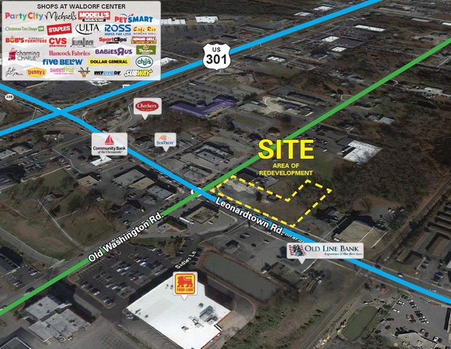
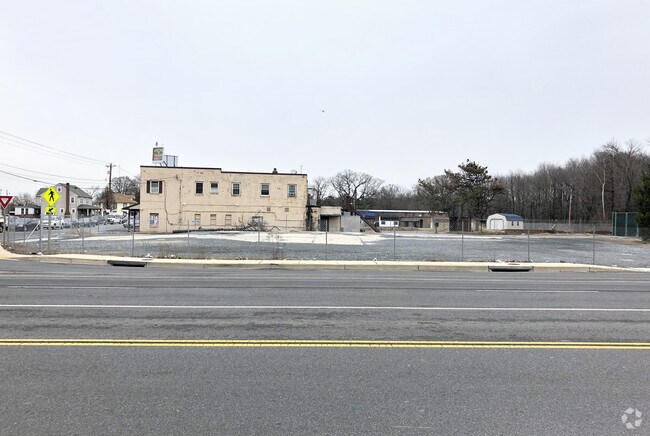
Leonardtown Rd, Waldorf, MD 20601

Current Lease Availabilities
NEARBY LISTINGS FOR SALE OR LEASE
Property Detail
Leonardtown Rd
Washington-Arlington-Alexandria, DC-VA-MD-WV
Waldorf
06-056458
0.7802 AC RT 5 WALDORF
Commercialnec
Charles
X
Maryland
24017C0185C
0.78 AC
0
Charles County
2025
Washington, DC
850802
DEMOGRAPHICS near Leonardtown Rd
1 Mile
3 Mile
5 Mile
2024 Total Population
3,770
66,924
98,366
2029 Population
3,957
69,784
102,520
Pop Growth 2024-2029
+ 4.96%
+ 4.27%
+ 4.22%
Average Age
36
37
38
2024 Total Households
1,367
24,223
34,880
HH Growth 2024-2029
+ 4.90%
+ 4.26%
+ 4.22%
Median Household Inc
$95,890
$98,016
$105,253
Avg Household Size
2.70
2.70
2.80
2024 Avg HH Vehicles
2.00
2.00
2.00
Median Home Value
$326,260
$333,234
$358,984
Median Year Built
1993
1989
1992
Nearby Places
Map Layers
Map Styles
 Street
 Aerial
- Restaurants
- Banks
- Shops
- Fitness
- Groceries
PUBLIC TRANSPORTATION
AIRPORT
Ronald Reagan Washington Ntl
DRIVE
WALK
Distance
Ronald Reagan Washington Ntl
45 min
27.2 mi
Freight Ports
Port of Baltimore
DRIVE
WALK
Distance
Port of Baltimore
78 min
53.8 mi
Nearby Properties
Address
Land Use
TOTAL SIZE
Lot Size
Zoning
Address
Land Use
TOTAL SIZE
Lot Size
Zoning
714,134 SF
29.53 AC
PUD
Address
Land Use
TOTAL SIZE
Lot Size
Zoning
392,898 SF
36.37 AC
PRD
Address
Land Use
TOTAL SIZE
Lot Size
Zoning
477,958 SF
47.50 AC
CB
Address
Land Use
TOTAL SIZE
Lot Size
Zoning
287,760 SF
16.27 AC
PUD
Address
Land Use
TOTAL SIZE
Lot Size
Zoning
267,264 SF
26.49 AC
PUD
Address
Land Use
TOTAL SIZE
Lot Size
Zoning
312,478 SF
54.26 AC
PUD
Address
Land Use
TOTAL SIZE
Lot Size
Zoning
392,124 SF
38.73 AC
PUD
Address
Land Use
TOTAL SIZE
Lot Size
Zoning
265,637 SF
54.72 AC
RH
Address
Land Use
TOTAL SIZE
Lot Size
Zoning
206,966 SF
32.61 AC
CB
Address
Land Use
TOTAL SIZE
Lot Size
Zoning
188,284 SF
9.02 AC
RM
Address
Land Use
TOTAL SIZE
Lot Size
Zoning
262,779 SF
26.84 AC
CB
Address
Land Use
TOTAL SIZE
Lot Size
Zoning
136,192 SF
17.85 AC
PUD
Address
Land Use
TOTAL SIZE
Lot Size
Zoning
239,208 SF
13.51 AC
PUD
Address
Land Use
TOTAL SIZE
Lot Size
Zoning
177,540 SF
27.64 AC
WCD
Address
Land Use
TOTAL SIZE
Lot Size
Zoning
177,540 SF
12.66 AC
WCD
Address
Land Use
TOTAL SIZE
Lot Size
Zoning
167,075 SF
11.01 AC
RH
Address
Land Use
TOTAL SIZE
Lot Size
Zoning
237,903 SF
16.03 AC
PRD
Address
Land Use
TOTAL SIZE
Lot Size
Zoning
207,928 SF
15.50 AC
PUD
Address
Land Use
TOTAL SIZE
Lot Size
Zoning
161,208 SF
10.99 AC
RH
Address
Land Use
TOTAL SIZE
Lot Size
Zoning
160,985 SF
24.85 AC
CB
Address
Land Use
TOTAL SIZE
Lot Size
Zoning
143,728 SF
19.71 AC
CB
Address
Land Use
TOTAL SIZE
Lot Size
Zoning
86,880 SF
22.18 AC
PUD
Address
Land Use
TOTAL SIZE
Lot Size
Zoning
194,972 SF
59.84 AC
RH
Address
Land Use
TOTAL SIZE
Lot Size
Zoning
145,749 SF
20.15 AC
PUD
Address
Land Use
TOTAL SIZE
Lot Size
Zoning
132,745 SF
2.59 AC
CC
Address
Land Use
TOTAL SIZE
Lot Size
Zoning
118,880 SF
3.78 AC
PUD
Address
Land Use
TOTAL SIZE
Lot Size
Zoning
121,968 SF
2.23 AC
PUD
Address
Land Use
TOTAL SIZE
Lot Size
Zoning
109,304 SF
9.09 AC
PUD
Address
Land Use
TOTAL SIZE
Lot Size
Zoning
53,318 SF
20.01 AC
PUD
Address
Land Use
TOTAL SIZE
Lot Size
Zoning
147,800 SF
4.54 AC
RH
The World's #1 Commercial Real Estate Marketplace
Connect with us
© 2025 CoStar Group
The information above has been obtained from sources believed reliable. While we do not doubt its accuracy we have not verified it and make no guarantee, warranty or representation about it. It is your responsibility to independently confirm its accuracy and completeness. Any projections, opinions, assumptions, or estimates used are for example only and do not represent the current or future performance of the property. The value of this transaction to you depends on tax and other factors which should be evaluated by your tax, financial, and legal advisors. You and your advisors should conduct a careful, independent investigation of the property to determine to your satisfaction the suitability of the property for your needs.