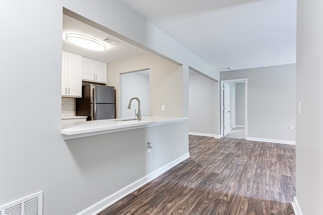
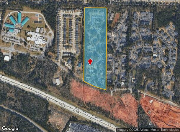
Property Record
3110 Mount Zion Rd, Stockbridge, GA 30281
NEARBY LISTINGS FOR SALE OR LEASE
-
-
View all Stockbridge listings for sale on LoopNet.com
Property Detail
3110 Mount Zion Rd
12-0074A-00A-004
Clayton
Gardenaptcourtapt5plusunits
Georgia
X
74
13063C0091F
20 AC
2024
Clayton County
2024
Atlanta
040632
Atlanta-Sandy Springs-Roswell, GA
160 SF
DEMOGRAPHICS near 3110 Mount Zion Rd
1 Mile
3 Mile
5 Mile
2024 Total Population
9,715
64,969
145,734
2029 Population
9,609
66,002
148,929
Pop Growth 2024-2029
(1.09%)
+ 1.59%
+ 2.19%
Average Age
35
37
37
2024 Total Households
3,744
23,310
52,261
HH Growth 2024-2029
(1.42%)
+ 1.57%
+ 2.30%
Median Household Inc
$49,075
$59,607
$58,177
Avg Household Size
2.60
2.70
2.70
2024 Avg HH Vehicles
2.00
2.00
2.00
Median Home Value
$178,888
$185,972
$183,802
Median Year Built
1995
1992
1990
Nearby Places
- Restaurants
- Banks
- Shops
- Fitness
- Groceries
PUBLIC TRANSPORTATION
AIRPORT
Hartsfield - Jackson Atlanta International
DRIVE
WALK
Distance
Hartsfield - Jackson Atlanta International
21 min
12.4 mi
Freight Ports
Georgia Ports - Savannah
DRIVE
WALK
Distance
Georgia Ports - Savannah
258 min
231.3 mi
Nearby Properties
Address
Land Use
TOTAL SIZE
Lot Size
Zoning
Address
Land Use
TOTAL SIZE
Lot Size
Zoning
368 SF
42.85 AC
RM
Address
Land Use
TOTAL SIZE
Lot Size
Zoning
284 SF
29 AC
RM
Address
Land Use
TOTAL SIZE
Lot Size
Zoning
35,082 SF
31.82 AC
C3
Address
Land Use
TOTAL SIZE
Lot Size
Zoning
17,862 SF
30 AC
PD
Address
Land Use
TOTAL SIZE
Lot Size
Zoning
330 SF
33.30 AC
RM
Address
Land Use
TOTAL SIZE
Lot Size
Zoning
216 SF
31.17 AC
RM
Address
Land Use
TOTAL SIZE
Lot Size
Zoning
217,289 SF
52.12 AC
OI
Address
Land Use
TOTAL SIZE
Lot Size
Zoning
18.12 AC
MXR
Address
Land Use
TOTAL SIZE
Lot Size
Zoning
200 SF
19.94 AC
RM
Address
Land Use
TOTAL SIZE
Lot Size
Zoning
200 SF
23.02 AC
RM
Address
Land Use
TOTAL SIZE
Lot Size
Zoning
200 SF
20.23 AC
RM
Address
Land Use
TOTAL SIZE
Lot Size
Zoning
2,426 SF
19.79 AC
RM
Address
Land Use
TOTAL SIZE
Lot Size
Zoning
260 SF
33.31 AC
MXR
Address
Land Use
TOTAL SIZE
Lot Size
Zoning
707,780 SF
85.14 AC
MXI
Address
Land Use
TOTAL SIZE
Lot Size
Zoning
20.65 AC
RM
Address
Land Use
TOTAL SIZE
Lot Size
Zoning
158 SF
15.59 AC
RM
Address
Land Use
TOTAL SIZE
Lot Size
Zoning
87,449 SF
14 AC
MC
Address
Land Use
TOTAL SIZE
Lot Size
Zoning
200 SF
22 AC
RM
Address
Land Use
TOTAL SIZE
Lot Size
Zoning
200 SF
18.36 AC
RM
Address
Land Use
TOTAL SIZE
Lot Size
Zoning
1,140 SF
187.84 AC
MX
Address
Land Use
TOTAL SIZE
Lot Size
Zoning
200 SF
25 AC
RM
Address
Land Use
TOTAL SIZE
Lot Size
Zoning
188 SF
28.36 AC
RM
Address
Land Use
TOTAL SIZE
Lot Size
Zoning
200 SF
19 AC
RM
Address
Land Use
TOTAL SIZE
Lot Size
Zoning
525 SF
103.20 AC
RM
Address
Land Use
TOTAL SIZE
Lot Size
Zoning
180 SF
30 AC
RM
Address
Land Use
TOTAL SIZE
Lot Size
Zoning
182 SF
19.46 AC
RM
Address
Land Use
TOTAL SIZE
Lot Size
Zoning
240 SF
25.09 AC
RM
Address
Land Use
TOTAL SIZE
Lot Size
Zoning
512,321 SF
21.28 AC
C
Address
Land Use
TOTAL SIZE
Lot Size
Zoning
142,742 SF
27.10 AC
RS110
Address
Land Use
TOTAL SIZE
Lot Size
Zoning
30.90 AC
RS110
The World's #1 Commercial Real Estate Marketplace
Connect with us
© 2025 CoStar Group
The information above has been obtained from sources believed reliable. While we do not doubt its accuracy we have not verified it and make no guarantee, warranty or representation about it. It is your responsibility to independently confirm its accuracy and completeness. Any projections, opinions, assumptions, or estimates used are for example only and do not represent the current or future performance of the property. The value of this transaction to you depends on tax and other factors which should be evaluated by your tax, financial, and legal advisors. You and your advisors should conduct a careful, independent investigation of the property to determine to your satisfaction the suitability of the property for your needs.