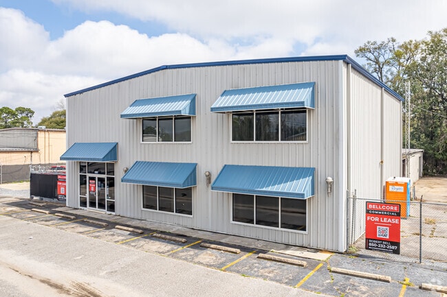
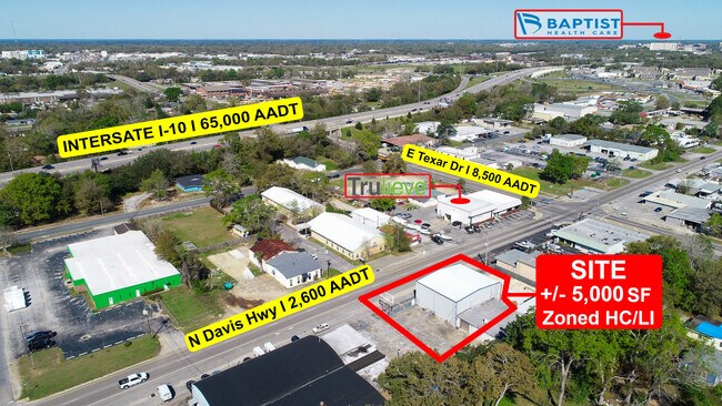
Property Record
3110 N Davis Hwy, Pensacola, FL 32503

Current Lease Availabilities
NEARBY LISTINGS FOR SALE OR LEASE
Property Detail
3110 N Davis Hwy
Pensacola-Ferry Pass-Brent, FL
North Shore 1St Addn
04-2S-30-6001-040-026
LTS 4 5 6 7 BLK 26 N PENSACOLA UNITS 1/2/3/4 PB 2 P 2/6/33/57 OR 8629 P 1424
Commercialnec
Escambia
X
Florida
12033C0380G
4
2023
0.64 AC
2024
Central Pensacola/S Brent
001500
Pensacola
15,069 SF
DEMOGRAPHICS near 3110 N Davis Hwy
1 Mile
3 Mile
5 Mile
2024 Total Population
7,731
64,245
134,887
2029 Population
7,974
66,143
137,877
Pop Growth 2024-2029
+ 3.14%
+ 2.95%
+ 2.22%
Average Age
39
39
39
2024 Total Households
3,078
25,541
55,202
HH Growth 2024-2029
+ 3.22%
+ 3.10%
+ 2.25%
Median Household Inc
$41,091
$44,906
$46,548
Avg Household Size
2.30
2.20
2.20
2024 Avg HH Vehicles
1.00
2.00
2.00
Median Home Value
$212,108
$235,870
$188,562
Median Year Built
1960
1969
1973
Nearby Places
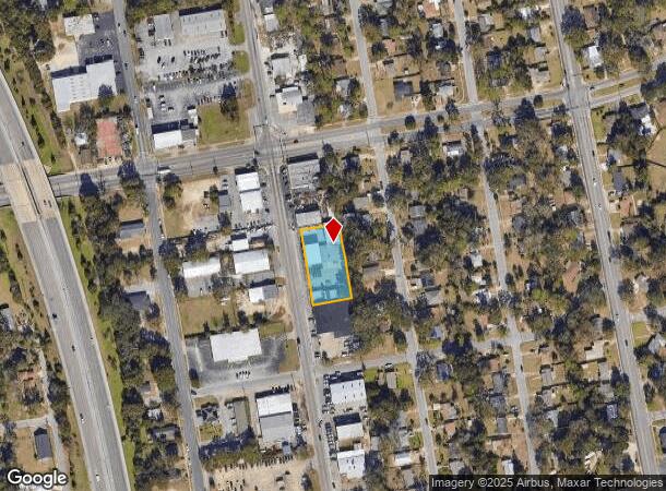
Map Layers
Map Styles
 Street
 Aerial
- Restaurants
- Banks
- Shops
- Fitness
- Groceries
PUBLIC TRANSPORTATION
AIRPORT
Pensacola International
DRIVE
WALK
Distance
Pensacola International
7 min
3.0 mi
Freight Ports
Port of Mobile
DRIVE
WALK
Distance
Port of Mobile
66 min
57.3 mi
Nearby Properties
Address
Land Use
TOTAL SIZE
Lot Size
Zoning
Address
Land Use
TOTAL SIZE
Lot Size
Zoning
1,487,006 SF
39.92 AC
C-1
Address
Land Use
TOTAL SIZE
Lot Size
Zoning
820,379 SF
52.64 AC
C-3
Address
Land Use
TOTAL SIZE
Lot Size
Zoning
431,154 SF
35.83 AC
ARZ
Address
Land Use
TOTAL SIZE
Lot Size
Zoning
39.22 AC
R-1AA
Address
Land Use
TOTAL SIZE
Lot Size
Zoning
544,835 SF
3.29 AC
C-2,C-2A
Address
Land Use
TOTAL SIZE
Lot Size
Zoning
1,479,067 SF
77.37 AC
COM
Address
Land Use
TOTAL SIZE
Lot Size
Zoning
5,732 SF
71.97 AC
R-1AA
Address
Land Use
TOTAL SIZE
Lot Size
Zoning
365,037 SF
5.79 AC
C-3
Address
Land Use
TOTAL SIZE
Lot Size
Zoning
518,234 SF
30.84 AC
C-2
Address
Land Use
TOTAL SIZE
Lot Size
Zoning
296,361 SF
13.03 AC
GRD
Address
Land Use
TOTAL SIZE
Lot Size
Zoning
655,451 SF
1,269.99 AC
ARZ
Address
Land Use
TOTAL SIZE
Lot Size
Zoning
368,724 SF
3.17 AC
C-2A
Address
Land Use
TOTAL SIZE
Lot Size
Zoning
56,970 SF
5.94 AC
WRD
Address
Land Use
TOTAL SIZE
Lot Size
Zoning
210,644 SF
13.14 AC
R-2
Address
Land Use
TOTAL SIZE
Lot Size
Zoning
289,397 SF
12.38 AC
PUB
Address
Land Use
TOTAL SIZE
Lot Size
Zoning
197,545 SF
8.60 AC
R-2A
Address
Land Use
TOTAL SIZE
Lot Size
Zoning
171,830 SF
1.20 AC
C-1
Address
Land Use
TOTAL SIZE
Lot Size
Zoning
485,500 SF
15.92 AC
COM
Address
Land Use
TOTAL SIZE
Lot Size
Zoning
158,425 SF
9.77 AC
R-2A
Address
Land Use
TOTAL SIZE
Lot Size
Zoning
263,938 SF
58.17 AC
C-1,R-1AA,
Address
Land Use
TOTAL SIZE
Lot Size
Zoning
353,428 SF
30.10 AC
M-1
Address
Land Use
TOTAL SIZE
Lot Size
Zoning
155,886 SF
5.98 AC
R-2
Address
Land Use
TOTAL SIZE
Lot Size
Zoning
189,008 SF
9.56 AC
R-2A
Address
Land Use
TOTAL SIZE
Lot Size
Zoning
327,045 SF
7.47 AC
C-2A
Address
Land Use
TOTAL SIZE
Lot Size
Zoning
168,911 SF
11.89 AC
C-2
Address
Land Use
TOTAL SIZE
Lot Size
Zoning
178,451 SF
3.88 AC
GRD
Address
Land Use
TOTAL SIZE
Lot Size
Zoning
114,000 SF
3.23 AC
C-2,C-2A
Address
Land Use
TOTAL SIZE
Lot Size
Zoning
96,686 SF
1.06 AC
C-2A
Address
Land Use
TOTAL SIZE
Lot Size
Zoning
156,182 SF
7.90 AC
R-2
Address
Land Use
TOTAL SIZE
Lot Size
Zoning
282,738 SF
14.64 AC
PUB
The World's #1 Commercial Real Estate Marketplace
Connect with us
© 2025 CoStar Group
The information above has been obtained from sources believed reliable. While we do not doubt its accuracy we have not verified it and make no guarantee, warranty or representation about it. It is your responsibility to independently confirm its accuracy and completeness. Any projections, opinions, assumptions, or estimates used are for example only and do not represent the current or future performance of the property. The value of this transaction to you depends on tax and other factors which should be evaluated by your tax, financial, and legal advisors. You and your advisors should conduct a careful, independent investigation of the property to determine to your satisfaction the suitability of the property for your needs.