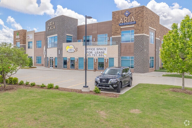
Property Record
3110 N Interstate Dr, Norman, OK 73072
Property Detail
3110 N Interstate Dr
Oklahoma City, OK
NRH MEDICAL PARK WEST 5 PUD LOT 31 BLOCK 6 ARIA PLAZA CONDOMINIUM PARK UNIT OWNERSHIP ESTATE UNIT 4 UND 4.75% C/E
R0189367
CLEVELAND
Officebuilding
Oklahoma
B and X Area of moderate flood hazard, usually the area between the limits of the 100-year and 500-year floods.
31
2025
0.36 AC
2025
Norman
201514
Oklahoma City
NEARBY LISTINGS FOR SALE OR LEASE
DEMOGRAPHICS near 3110 N Interstate Dr
1 mile
3 mile
5 mile
2025 Total Population
6,174
42,474
120,508
2030 Population
6,420
43,726
123,655
Pop Growth 2025-2030
+ 3.98%
+ 2.95%
+ 2.61%
Average Age
40
40
37
2025 Total Households
2,693
17,640
46,523
HH Growth 2025-2030
+ 4.49%
+ 3.10%
+ 2.80%
Median Household Inc
$86,575
$76,121
$72,706
Avg Household Size
2.20
2.30
2.40
2025 Avg HH Vehicles
2.00
2.00
2.00
Median Home Value
$339,009
$298,378
$269,610
Median Year Built
2006
1992
1990
Nearby Places
Map Layers
Map Styles
 Street
 Aerial
Layers
 Traffic
 Biking
Places
Listings with unknown addresses are not visible on the map
- Restaurants
- Banks
- Shops
- Fitness
- Groceries
PUBLIC TRANSPORTATION
AIRPORT
Will Rogers World
Drive
Walk
Distance
Will Rogers World
26 min
19.6 mi
SALE & LEASE HISTORY
LISTING DATE
SALE/LEASE

Oct 28, 2024
For Sale
Nov 15, 2021
For Sale
Mar 01, 2022
For Lease
Jul 14, 2022
For Sale
Jul 06, 2022
For Lease
Jul 02, 2024
For Sale
Aug 30, 2022
For Sale
Nearby Properties
Address
Land Use
TOTAL SIZE
Lot Size
Zoning
Address
Land Use
TOTAL SIZE
Lot Size
Zoning
146,265 SF
16.85 AC
Address
Land Use
TOTAL SIZE
Lot Size
Zoning
11.23 AC
Address
Land Use
TOTAL SIZE
Lot Size
Zoning
24.50 AC
Address
Land Use
TOTAL SIZE
Lot Size
Zoning
40,799 SF
3.07 AC
Address
Land Use
TOTAL SIZE
Lot Size
Zoning
4.86 AC
Address
Land Use
TOTAL SIZE
Lot Size
Zoning
174,742 SF
26.71 AC
Address
Land Use
TOTAL SIZE
Lot Size
Zoning
60,000 SF
4.39 AC
RM
Address
Land Use
TOTAL SIZE
Lot Size
Zoning
24.83 AC
Address
Land Use
TOTAL SIZE
Lot Size
Zoning
9.51 AC
Address
Land Use
TOTAL SIZE
Lot Size
Zoning
554,068 SF
71.81 AC
Address
Land Use
TOTAL SIZE
Lot Size
Zoning
30.47 AC
Address
Land Use
TOTAL SIZE
Lot Size
Zoning
191,169 SF
6.30 AC
I2
Address
Land Use
TOTAL SIZE
Lot Size
Zoning
32,789 SF
9.50 AC
I1
Address
Land Use
TOTAL SIZE
Lot Size
Zoning
Address
Land Use
TOTAL SIZE
Lot Size
Zoning
2,200 SF
12.41 AC
Address
Land Use
TOTAL SIZE
Lot Size
Zoning
292,511 SF
6.20 AC
Address
Land Use
TOTAL SIZE
Lot Size
Zoning
9.50 AC
Address
Land Use
TOTAL SIZE
Lot Size
Zoning
36,922 SF
6.21 AC
Address
Land Use
TOTAL SIZE
Lot Size
Zoning
39,801 SF
8.28 AC
Address
Land Use
TOTAL SIZE
Lot Size
Zoning
11,391 SF
1.10 AC
Address
Land Use
TOTAL SIZE
Lot Size
Zoning
35,127 SF
2.34 AC
C2
Address
Land Use
TOTAL SIZE
Lot Size
Zoning
36,140 SF
12.02 AC
Address
Land Use
TOTAL SIZE
Lot Size
Zoning
277,311 SF
5.88 AC
Address
Land Use
TOTAL SIZE
Lot Size
Zoning
5,764 SF
7.92 AC
Address
Land Use
TOTAL SIZE
Lot Size
Zoning
66,613 SF
6.92 AC
Address
Land Use
TOTAL SIZE
Lot Size
Zoning
18,768 SF
2.43 AC
CO
Address
Land Use
TOTAL SIZE
Lot Size
Zoning
20,270 SF
1.17 AC
R1
Address
Land Use
TOTAL SIZE
Lot Size
Zoning
34,400 SF
5.03 AC
Address
Land Use
TOTAL SIZE
Lot Size
Zoning
443,969 SF
32.37 AC
C2
Address
Land Use
TOTAL SIZE
Lot Size
Zoning
77,626 SF
9.18 AC
The World's #1 Commercial Real Estate Marketplace
Connect with us
© 2026 CoStar Group
The information above has been obtained from sources believed reliable. While we do not doubt its accuracy we have not verified it and make no guarantee, warranty or representation about it. It is your responsibility to independently confirm its accuracy and completeness. Any projections, opinions, assumptions, or estimates used are for example only and do not represent the current or future performance of the property. The value of this transaction to you depends on tax and other factors which should be evaluated by your tax, financial, and legal advisors. You and your advisors should conduct a careful, independent investigation of the property to determine to your satisfaction the suitability of the property for your needs.