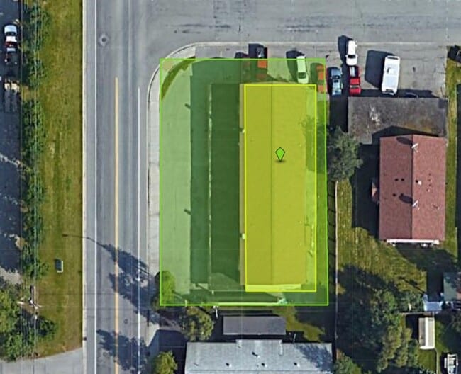
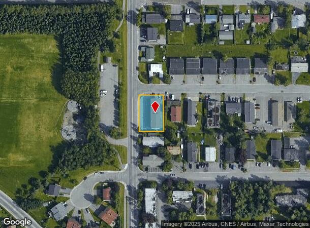
Property Record
3112 W 33Rd Ave, Anchorage, AK 99517
NEARBY LISTINGS FOR SALE OR LEASE
-
-
View all Anchorage listings for sale on LoopNet.com
Property Detail
3112 W 33Rd Ave
Anchorage, AK
New Mcrae Addition
01008177000
NEW MCRAE BLK 2 LT 5A OF 4
Apartment
Anchorage
X
Alaska
0200050730D
5a
2024
0.29 AC
2025
Turnagain South/Columbia Park
002202
Anchorage
9,720 SF
DEMOGRAPHICS near 3112 W 33Rd Ave
1 Mile
3 Mile
5 Mile
2024 Total Population
14,619
57,823
134,056
2029 Population
14,403
57,174
132,263
Pop Growth 2024-2029
(1.48%)
(1.12%)
(1.34%)
Average Age
40
39
38
2024 Total Households
6,199
24,770
53,409
HH Growth 2024-2029
(1.53%)
(1.14%)
(1.37%)
Median Household Inc
$88,155
$79,717
$81,590
Avg Household Size
2.30
2.20
2.40
2024 Avg HH Vehicles
2.00
2.00
2.00
Median Home Value
$344,230
$350,897
$329,054
Median Year Built
1975
1976
1979
Nearby Places
Map Layers
Map Styles
 Street
 Aerial
- Restaurants
- Banks
- Shops
- Fitness
- Groceries
PUBLIC TRANSPORTATION
AIRPORT
Ted Stevens Anchorage International
DRIVE
WALK
Distance
Ted Stevens Anchorage International
7 min
3.0 mi
Merrill Field
DRIVE
WALK
Distance
Merrill Field
14 min
6.0 mi
Freight Ports
Port of Anchorage
DRIVE
WALK
Distance
Port of Anchorage
14 min
5.7 mi
Nearby Properties
Address
Land Use
TOTAL SIZE
Lot Size
Zoning
Address
Land Use
TOTAL SIZE
Lot Size
Zoning
181,492 SF
1.70 AC
B2B
Address
Land Use
TOTAL SIZE
Lot Size
Zoning
199,186 SF
2.11 AC
B2B
Address
Land Use
TOTAL SIZE
Lot Size
Zoning
127,232 SF
4.55 AC
B2B
Address
Land Use
TOTAL SIZE
Lot Size
Zoning
91,034 SF
63.70 AC
TR
Address
Land Use
TOTAL SIZE
Lot Size
Zoning
171,692 SF
23.09 AC
I1
Address
Land Use
TOTAL SIZE
Lot Size
Zoning
117,702 SF
9.85 AC
B3SL
Address
Land Use
TOTAL SIZE
Lot Size
Zoning
134,626 SF
16.91 AC
PLI
Address
Land Use
TOTAL SIZE
Lot Size
Zoning
87,865 SF
0.48 AC
B2B
Address
Land Use
TOTAL SIZE
Lot Size
Zoning
195,079 SF
44.79 AC
PLI
Address
Land Use
TOTAL SIZE
Lot Size
Zoning
86,316 SF
2 AC
B2B
Address
Land Use
TOTAL SIZE
Lot Size
Zoning
61,127 SF
3.04 AC
B3
Address
Land Use
TOTAL SIZE
Lot Size
Zoning
191.79 AC
PLI
Address
Land Use
TOTAL SIZE
Lot Size
Zoning
65,314 SF
111.15 AC
PLI
Address
Land Use
TOTAL SIZE
Lot Size
Zoning
121,359 SF
4.35 AC
B3SL
Address
Land Use
TOTAL SIZE
Lot Size
Zoning
47,774 SF
1.61 AC
B2B
Address
Land Use
TOTAL SIZE
Lot Size
Zoning
36,837 SF
0.80 AC
B2B
Address
Land Use
TOTAL SIZE
Lot Size
Zoning
124,058 SF
18.15 AC
B3
Address
Land Use
TOTAL SIZE
Lot Size
Zoning
56,747 SF
6.89 AC
B3SL
Address
Land Use
TOTAL SIZE
Lot Size
Zoning
33,360 SF
0.96 AC
B2B
Address
Land Use
TOTAL SIZE
Lot Size
Zoning
66,354 SF
44.23 AC
I2
Address
Land Use
TOTAL SIZE
Lot Size
Zoning
7,711 SF
1.93 AC
B2A
Address
Land Use
TOTAL SIZE
Lot Size
Zoning
242,189 SF
21.83 AC
I2
Address
Land Use
TOTAL SIZE
Lot Size
Zoning
168,640 SF
3.38 AC
I2
Address
Land Use
TOTAL SIZE
Lot Size
Zoning
84,157 SF
3.41 AC
B3
Address
Land Use
TOTAL SIZE
Lot Size
Zoning
170,000 SF
2.40 AC
B2A
Address
Land Use
TOTAL SIZE
Lot Size
Zoning
341,267 SF
5.51 AC
TR
Address
Land Use
TOTAL SIZE
Lot Size
Zoning
217,754 SF
14.42 AC
I1
Address
Land Use
TOTAL SIZE
Lot Size
Zoning
171,800 SF
1.67 AC
B3
Address
Land Use
TOTAL SIZE
Lot Size
Zoning
19,638 SF
0.97 AC
B3
Address
Land Use
TOTAL SIZE
Lot Size
Zoning
79.26 AC
PLI
The World's #1 Commercial Real Estate Marketplace
Connect with us
© 2026 CoStar Group
The information above has been obtained from sources believed reliable. While we do not doubt its accuracy we have not verified it and make no guarantee, warranty or representation about it. It is your responsibility to independently confirm its accuracy and completeness. Any projections, opinions, assumptions, or estimates used are for example only and do not represent the current or future performance of the property. The value of this transaction to you depends on tax and other factors which should be evaluated by your tax, financial, and legal advisors. You and your advisors should conduct a careful, independent investigation of the property to determine to your satisfaction the suitability of the property for your needs.