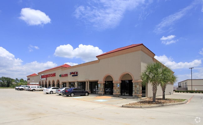
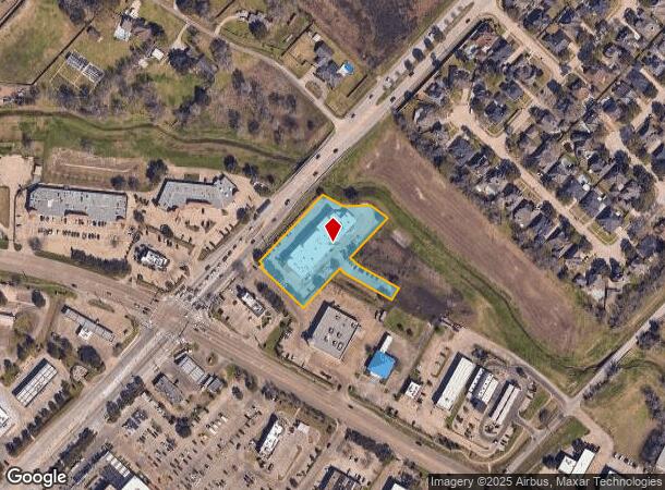
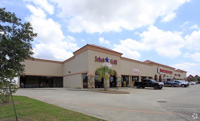
Property Record
3115 Dixie Farm Rd, Pearland, TX 77581
NEARBY LISTINGS FOR SALE OR LEASE
Property Detail
3115 Dixie Farm Rd
Houston-The Woodlands-Sugar Land, TX
Pearland Corner Ii Lp (A0070 Wdc Hall) (
7032-2001-001
PEARLAND CORNER II LP (A0070 WDC HALL) (PEARLAND) BLK 1 LOT 1 ACRES 1.719
Commercialnec
Brazoria
AE
Texas
48039C0065K
1
2024
1.72 AC
2025
Southeast Outlier
660100
Houston
16,368 SF
DEMOGRAPHICS near 3115 Dixie Farm Rd
1 Mile
3 Mile
5 Mile
2024 Total Population
9,070
68,555
186,911
2029 Population
9,858
71,866
194,726
Pop Growth 2024-2029
+ 8.69%
+ 4.83%
+ 4.18%
Average Age
41
39
37
2024 Total Households
3,312
23,375
63,564
HH Growth 2024-2029
+ 8.79%
+ 5.06%
+ 4.26%
Median Household Inc
$107,372
$105,930
$86,902
Avg Household Size
2.70
2.90
2.90
2024 Avg HH Vehicles
2.00
2.00
2.00
Median Home Value
$277,254
$278,468
$253,297
Median Year Built
1991
1993
1990
Nearby Places
Map Layers
Map Styles
 Street
 Aerial
- Restaurants
- Banks
- Shops
- Fitness
- Groceries
PUBLIC TRANSPORTATION
AIRPORT
William P Hobby
DRIVE
WALK
Distance
William P Hobby
21 min
9.7 mi
George Bush Intcntl/Houston
DRIVE
WALK
Distance
George Bush Intcntl/Houston
54 min
41.5 mi
Freight Ports
Port of Houston
DRIVE
WALK
Distance
Port of Houston
30 min
18.4 mi
SALE & LEASE HISTORY
LISTING DATE
SALE/LEASE

Sep 25, 2016
For Lease
Nearby Properties
Address
Land Use
TOTAL SIZE
Lot Size
Zoning
Address
Land Use
TOTAL SIZE
Lot Size
Zoning
83.37 AC
0004
Address
Land Use
TOTAL SIZE
Lot Size
Zoning
236,642 SF
11.48 AC
Address
Land Use
TOTAL SIZE
Lot Size
Zoning
128,754 SF
14.83 AC
Address
Land Use
TOTAL SIZE
Lot Size
Zoning
97,736 SF
16.49 AC
Address
Land Use
TOTAL SIZE
Lot Size
Zoning
102,056 SF
5.59 AC
Address
Land Use
TOTAL SIZE
Lot Size
Zoning
142,155 SF
19.16 AC
SP
Address
Land Use
TOTAL SIZE
Lot Size
Zoning
125,028 SF
5.59 AC
Address
Land Use
TOTAL SIZE
Lot Size
Zoning
144,879 SF
8.91 AC
Address
Land Use
TOTAL SIZE
Lot Size
Zoning
161,803 SF
54.82 AC
Address
Land Use
TOTAL SIZE
Lot Size
Zoning
110,990 SF
18.25 AC
Address
Land Use
TOTAL SIZE
Lot Size
Zoning
155,524 SF
7.86 AC
Address
Land Use
TOTAL SIZE
Lot Size
Zoning
113,376 SF
9.80 AC
Address
Land Use
TOTAL SIZE
Lot Size
Zoning
148,902 SF
11.40 AC
Address
Land Use
TOTAL SIZE
Lot Size
Zoning
111,642 SF
9.53 AC
Address
Land Use
TOTAL SIZE
Lot Size
Zoning
173,324 SF
7.09 AC
Address
Land Use
TOTAL SIZE
Lot Size
Zoning
115,805 SF
10.12 AC
SP
Address
Land Use
TOTAL SIZE
Lot Size
Zoning
134,596 SF
7.21 AC
Address
Land Use
TOTAL SIZE
Lot Size
Zoning
99,042 SF
13 AC
MFRM
Address
Land Use
TOTAL SIZE
Lot Size
Zoning
229,097 SF
22.66 AC
Address
Land Use
TOTAL SIZE
Lot Size
Zoning
67,595 SF
4.97 AC
Address
Land Use
TOTAL SIZE
Lot Size
Zoning
138,839 SF
7.46 AC
MFRH
Address
Land Use
TOTAL SIZE
Lot Size
Zoning
83,995 SF
21.74 AC
CSC
Address
Land Use
TOTAL SIZE
Lot Size
Zoning
112,800 SF
3.20 AC
Address
Land Use
TOTAL SIZE
Lot Size
Zoning
54,802 SF
12.63 AC
0014
Address
Land Use
TOTAL SIZE
Lot Size
Zoning
49.29 AC
0007
Address
Land Use
TOTAL SIZE
Lot Size
Zoning
156,021 SF
6.99 AC
Address
Land Use
TOTAL SIZE
Lot Size
Zoning
80,715 SF
8.73 AC
Address
Land Use
TOTAL SIZE
Lot Size
Zoning
6,948 SF
54.94 AC
2080
Address
Land Use
TOTAL SIZE
Lot Size
Zoning
63,615 SF
6.42 AC
0010
Address
Land Use
TOTAL SIZE
Lot Size
Zoning
86,550 SF
8.45 AC
The World's #1 Commercial Real Estate Marketplace
Connect with us
© 2025 CoStar Group
The information above has been obtained from sources believed reliable. While we do not doubt its accuracy we have not verified it and make no guarantee, warranty or representation about it. It is your responsibility to independently confirm its accuracy and completeness. Any projections, opinions, assumptions, or estimates used are for example only and do not represent the current or future performance of the property. The value of this transaction to you depends on tax and other factors which should be evaluated by your tax, financial, and legal advisors. You and your advisors should conduct a careful, independent investigation of the property to determine to your satisfaction the suitability of the property for your needs.