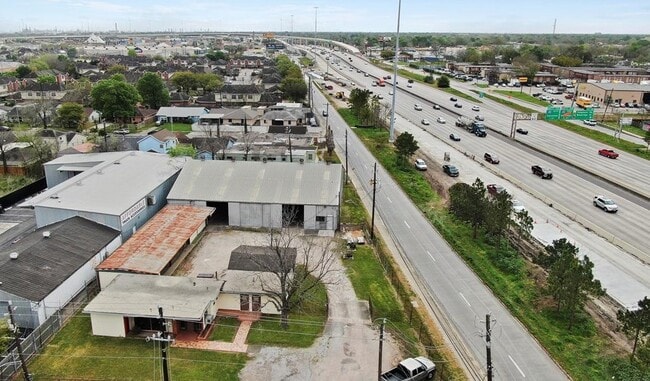
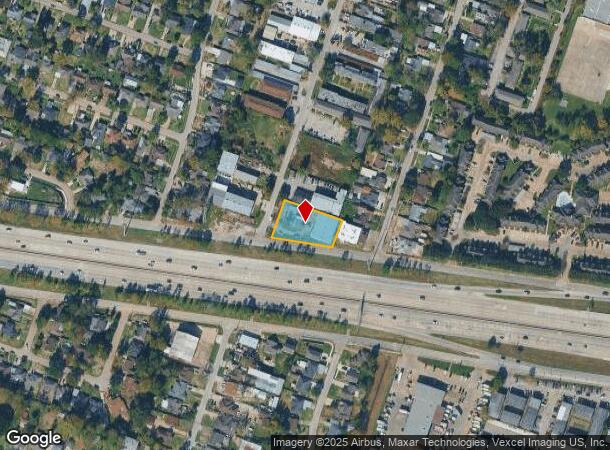
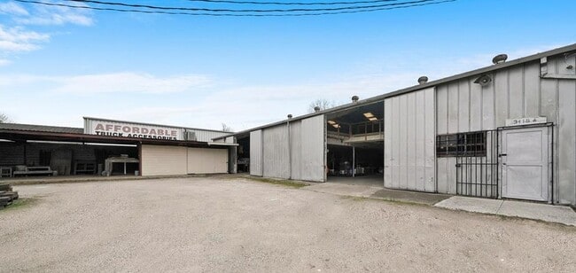
Property Record
3115 Golfcrest Blvd, Houston, TX 77087
NEARBY LISTINGS FOR SALE OR LEASE
Property Detail
3115 Golfcrest Blvd
0582950000045
Carter Anna Acreage
Warehouse
TR 11A & 12B CARTER ANNA ACREAGE
X
Harris
48201C0885N
Texas
2024
0.54 AC
2025
South Inner Loop
311701
Houston
7,865 SF
Houston-The Woodlands-Sugar Land, TX
DEMOGRAPHICS near 3115 Golfcrest Blvd
1 Mile
3 Mile
5 Mile
2024 Total Population
17,430
144,777
323,655
2029 Population
17,734
148,532
334,287
Pop Growth 2024-2029
+ 1.74%
+ 2.59%
+ 3.28%
Average Age
35
36
37
2024 Total Households
5,701
47,866
115,650
HH Growth 2024-2029
+ 1.67%
+ 2.70%
+ 3.50%
Median Household Inc
$39,614
$39,951
$42,949
Avg Household Size
3.00
2.80
2.60
2024 Avg HH Vehicles
2.00
2.00
2.00
Median Home Value
$121,689
$146,153
$163,316
Median Year Built
1968
1959
1965
Nearby Places
Map Layers
Map Styles
 Street
 Aerial
- Restaurants
- Banks
- Shops
- Fitness
- Groceries
PUBLIC TRANSPORTATION
COMMUTER RAIL
Houston (Sunset Limited - Amtrak)
DRIVE
WALK
Distance
Houston (Sunset Limited - Amtrak)
12 min
7.6 mi
AIRPORT
William P Hobby
DRIVE
WALK
Distance
William P Hobby
15 min
6.5 mi
George Bush Intcntl/Houston
DRIVE
WALK
Distance
George Bush Intcntl/Houston
35 min
27.3 mi
Freight Ports
Port of Houston
DRIVE
WALK
Distance
Port of Houston
12 min
6.4 mi
SALE & LEASE HISTORY
LISTING DATE
SALE/LEASE

Mar 20, 2020
For Sale
Nearby Properties
Address
Land Use
TOTAL SIZE
Lot Size
Zoning
Address
Land Use
TOTAL SIZE
Lot Size
Zoning
453,987 SF
4.33 AC
Address
Land Use
TOTAL SIZE
Lot Size
Zoning
403,242 SF
46.18 AC
Address
Land Use
TOTAL SIZE
Lot Size
Zoning
1,171,276 SF
44.19 AC
Address
Land Use
TOTAL SIZE
Lot Size
Zoning
159,235 SF
1.49 AC
Address
Land Use
TOTAL SIZE
Lot Size
Zoning
310,171 SF
2.35 AC
Address
Land Use
TOTAL SIZE
Lot Size
Zoning
389,108 SF
37.39 AC
Address
Land Use
TOTAL SIZE
Lot Size
Zoning
198,023 SF
17.87 AC
Address
Land Use
TOTAL SIZE
Lot Size
Zoning
33.97 AC
Address
Land Use
TOTAL SIZE
Lot Size
Zoning
901,984 SF
59.37 AC
Address
Land Use
TOTAL SIZE
Lot Size
Zoning
504,018 SF
37.16 AC
Address
Land Use
TOTAL SIZE
Lot Size
Zoning
419,760 SF
15.27 AC
Address
Land Use
TOTAL SIZE
Lot Size
Zoning
785,097 SF
27.77 AC
Address
Land Use
TOTAL SIZE
Lot Size
Zoning
985,528 SF
22.64 AC
Address
Land Use
TOTAL SIZE
Lot Size
Zoning
232,915 SF
7.89 AC
Address
Land Use
TOTAL SIZE
Lot Size
Zoning
228,886 SF
1.85 AC
Address
Land Use
TOTAL SIZE
Lot Size
Zoning
267,844 SF
10.98 AC
Address
Land Use
TOTAL SIZE
Lot Size
Zoning
194,296 SF
15.13 AC
Address
Land Use
TOTAL SIZE
Lot Size
Zoning
210,476 SF
9.60 AC
Address
Land Use
TOTAL SIZE
Lot Size
Zoning
595,069 SF
17.77 AC
Address
Land Use
TOTAL SIZE
Lot Size
Zoning
113,688 SF
4 AC
Address
Land Use
TOTAL SIZE
Lot Size
Zoning
257,481 SF
9.28 AC
Address
Land Use
TOTAL SIZE
Lot Size
Zoning
78,073 SF
5.45 AC
Address
Land Use
TOTAL SIZE
Lot Size
Zoning
241,999 SF
8.46 AC
Address
Land Use
TOTAL SIZE
Lot Size
Zoning
54,077 SF
5.06 AC
Address
Land Use
TOTAL SIZE
Lot Size
Zoning
44,327 SF
5.40 AC
Address
Land Use
TOTAL SIZE
Lot Size
Zoning
126,000 SF
1.51 AC
Address
Land Use
TOTAL SIZE
Lot Size
Zoning
445,535 SF
36.94 AC
Address
Land Use
TOTAL SIZE
Lot Size
Zoning
241,219 SF
8.92 AC
Address
Land Use
TOTAL SIZE
Lot Size
Zoning
155,657 SF
3.59 AC
Address
Land Use
TOTAL SIZE
Lot Size
Zoning
177,406 SF
10.86 AC
The World's #1 Commercial Real Estate Marketplace
Connect with us
© 2025 CoStar Group
The information above has been obtained from sources believed reliable. While we do not doubt its accuracy we have not verified it and make no guarantee, warranty or representation about it. It is your responsibility to independently confirm its accuracy and completeness. Any projections, opinions, assumptions, or estimates used are for example only and do not represent the current or future performance of the property. The value of this transaction to you depends on tax and other factors which should be evaluated by your tax, financial, and legal advisors. You and your advisors should conduct a careful, independent investigation of the property to determine to your satisfaction the suitability of the property for your needs.