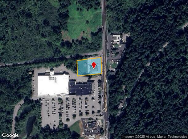
Property Record
3117 Route 22, Patterson, NY 12563
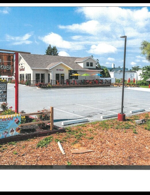

This Property Is For Sale
NEARBY LISTINGS FOR SALE OR LEASE
Property Detail
3117 Route 22
372400-004-000-0001-039-000-0000
Putnam
Supermarket
New York
X
39.00
36079C0064E
0.80 AC
2024
Brewster
2024
Westchester/So Connecticut
010202
Dutchess County-Putnam County, NY
4,792 SF
DEMOGRAPHICS near 3117 Route 22
1 Mile
3 Mile
5 Mile
2024 Total Population
677
6,346
23,716
2029 Population
672
6,323
23,814
Pop Growth 2024-2029
(0.74%)
(0.36%)
+ 0.41%
Average Age
43
43
43
2024 Total Households
221
2,008
8,447
HH Growth 2024-2029
(0.90%)
(0.45%)
+ 0.38%
Median Household Inc
$99,166
$103,096
$105,992
Avg Household Size
2.80
2.60
2.60
2024 Avg HH Vehicles
2.00
2.00
2.00
Median Home Value
$513,513
$422,356
$379,968
Median Year Built
1969
1980
1968
Nearby Places
Map Layers
Map Styles
 Street
 Aerial
- Restaurants
- Banks
- Shops
- Fitness
- Groceries
PUBLIC TRANSPORTATION
COMMUTER RAIL
Patterson Station (Harlem Line - Metro-North Commuter Railroad Company (Metro-North))
DRIVE
WALK
Distance
Patterson Station (Harlem Line - Metro-North Commuter Railroad Company (Metro-North))
2 min
19 min
1.0 mi
Pawling Station (Harlem Line - Metro-North Commuter Railroad Company (Metro-North))
DRIVE
WALK
Distance
Pawling Station (Harlem Line - Metro-North Commuter Railroad Company (Metro-North))
7 min
3.7 mi
AIRPORT
New York Stewart International
DRIVE
WALK
Distance
New York Stewart International
45 min
37.3 mi
Freight Ports
NY - Red Hook Container Terminal
DRIVE
WALK
Distance
NY - Red Hook Container Terminal
1 min
61.4 mi
Nearby Properties
Address
Land Use
TOTAL SIZE
Lot Size
Zoning
Address
Land Use
TOTAL SIZE
Lot Size
Zoning
1,498,293 SF
361.91 AC
R4
Address
Land Use
TOTAL SIZE
Lot Size
Zoning
12,064 SF
12.10 AC
C1
Address
Land Use
TOTAL SIZE
Lot Size
Zoning
84,651 SF
22.01 AC
C1
Address
Land Use
TOTAL SIZE
Lot Size
Zoning
129,961 SF
31.51 AC
C1
Address
Land Use
TOTAL SIZE
Lot Size
Zoning
77,537 SF
19.41 AC
R1
Address
Land Use
TOTAL SIZE
Lot Size
Zoning
12,871 SF
277.38 AC
R4
Address
Land Use
TOTAL SIZE
Lot Size
Zoning
19,768 SF
2.70 AC
GB
Address
Land Use
TOTAL SIZE
Lot Size
Zoning
50,339 SF
14.96 AC
C1
Address
Land Use
TOTAL SIZE
Lot Size
Zoning
22,670 SF
10.58 AC
C1
Address
Land Use
TOTAL SIZE
Lot Size
Zoning
29,220 SF
23.83 AC
C1
Address
Land Use
TOTAL SIZE
Lot Size
Zoning
5.54 AC
Address
Land Use
TOTAL SIZE
Lot Size
Zoning
24,550 SF
2.02 AC
GB
Address
Land Use
TOTAL SIZE
Lot Size
Zoning
32.64 AC
R1
Address
Land Use
TOTAL SIZE
Lot Size
Zoning
17,792 SF
8.52 AC
R1
Address
Land Use
TOTAL SIZE
Lot Size
Zoning
10,370 SF
30.93 AC
R4
Address
Land Use
TOTAL SIZE
Lot Size
Zoning
2.50 AC
C1
Address
Land Use
TOTAL SIZE
Lot Size
Zoning
604.69 AC
R4
Address
Land Use
TOTAL SIZE
Lot Size
Zoning
0.23 AC
R4
Address
Land Use
TOTAL SIZE
Lot Size
Zoning
1.26 AC
GB
Address
Land Use
TOTAL SIZE
Lot Size
Zoning
13,961 SF
2 AC
GB
Address
Land Use
TOTAL SIZE
Lot Size
Zoning
261.39 AC
R4
Address
Land Use
TOTAL SIZE
Lot Size
Zoning
290.21 AC
R4
Address
Land Use
TOTAL SIZE
Lot Size
Zoning
96.55 AC
R4
Address
Land Use
TOTAL SIZE
Lot Size
Zoning
237.25 AC
R4
Address
Land Use
TOTAL SIZE
Lot Size
Zoning
24,590 SF
421.13 AC
R-4
Address
Land Use
TOTAL SIZE
Lot Size
Zoning
7,504 SF
8.87 AC
R4
Address
Land Use
TOTAL SIZE
Lot Size
Zoning
12.80 AC
VRD
Address
Land Use
TOTAL SIZE
Lot Size
Zoning
6,406 SF
19.18 AC
R4
Address
Land Use
TOTAL SIZE
Lot Size
Zoning
4,800 SF
4.60 AC
C1
Address
Land Use
TOTAL SIZE
Lot Size
Zoning
792 SF
34.42 AC
R4
The World's #1 Commercial Real Estate Marketplace
Connect with us
© 2025 CoStar Group
The information above has been obtained from sources believed reliable. While we do not doubt its accuracy we have not verified it and make no guarantee, warranty or representation about it. It is your responsibility to independently confirm its accuracy and completeness. Any projections, opinions, assumptions, or estimates used are for example only and do not represent the current or future performance of the property. The value of this transaction to you depends on tax and other factors which should be evaluated by your tax, financial, and legal advisors. You and your advisors should conduct a careful, independent investigation of the property to determine to your satisfaction the suitability of the property for your needs.