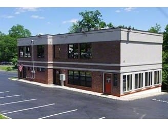
Property Record
3117 State Route 10, Denville, NJ 07834


NEARBY LISTINGS FOR SALE OR LEASE
Property Detail
3117 State Route 10
Newark, NJ-PA
Morris
08-20701-0000-00025
New Jersey
Officebuilding
25
2024
1 AC
2025
Western Morris
041500
Northern New Jersey
4,860 SF
DEMOGRAPHICS near 3117 State Route 10
1 Mile
3 Mile
5 Mile
2024 Total Population
3,747
70,239
160,487
2029 Population
3,734
70,157
160,665
Pop Growth 2024-2029
(0.35%)
(0.12%)
+ 0.11%
Average Age
42
41
41
2024 Total Households
1,389
25,032
58,341
HH Growth 2024-2029
(0.36%)
(0.16%)
+ 0.14%
Median Household Inc
$176,932
$109,872
$118,147
Avg Household Size
2.70
2.70
2.70
2024 Avg HH Vehicles
2.00
2.00
2.00
Median Home Value
$629,557
$452,831
$472,536
Median Year Built
1990
1968
1968
Nearby Places
Map Layers
Map Styles
 Street
 Aerial
- Restaurants
- Banks
- Shops
- Fitness
- Groceries
PUBLIC TRANSPORTATION
COMMUTER RAIL
Mount Tabor (Morris & Essex Morristown Line - NJ Transit Commuter Rail (NJ Transit))
DRIVE
WALK
Distance
Mount Tabor (Morris & Essex Morristown Line - NJ Transit Commuter Rail (NJ Transit))
7 min
2.7 mi
Denville (Montclair-Boonton Line - NJ Transit Commuter Rail (NJ Transit), Morris & Essex Morristown Line - NJ Transit Commuter Rail (NJ Transit))
DRIVE
WALK
Distance
Denville (Montclair-Boonton Line - NJ Transit Commuter Rail (NJ Transit), Morris & Essex Morristown Line - NJ Transit Commuter Rail (NJ Transit))
8 min
5.7 mi
AIRPORT
Newark Liberty International
DRIVE
WALK
Distance
Newark Liberty International
34 min
27.0 mi
Freight Ports
Maher Terminal
DRIVE
WALK
Distance
Maher Terminal
36 min
27.5 mi
SALE & LEASE HISTORY
LISTING DATE
SALE/LEASE

Sep 24, 2016
For Lease
Sep 24, 2016
For Sale
Sep 07, 2017
For Sale
Oct 03, 2019
For Lease
Aug 09, 2018
For Lease
Nearby Properties
Address
Land Use
TOTAL SIZE
Lot Size
Zoning
Address
Land Use
TOTAL SIZE
Lot Size
Zoning
2,023 SF
136.41 AC
R-R
Address
Land Use
TOTAL SIZE
Lot Size
Zoning
64.62 AC
R3
Address
Land Use
TOTAL SIZE
Lot Size
Zoning
95,368 SF
33.81 AC
RMF8
Address
Land Use
TOTAL SIZE
Lot Size
Zoning
32 AC
R-1M
Address
Land Use
TOTAL SIZE
Lot Size
Zoning
197,412 SF
28.60 AC
OSGU
Address
Land Use
TOTAL SIZE
Lot Size
Zoning
26,967 SF
14.06 AC
OB-4
Address
Land Use
TOTAL SIZE
Lot Size
Zoning
Address
Land Use
TOTAL SIZE
Lot Size
Zoning
156,564 SF
19.66 AC
B-2
Address
Land Use
TOTAL SIZE
Lot Size
Zoning
11,441 SF
109.20 AC
OSGU
Address
Land Use
TOTAL SIZE
Lot Size
Zoning
44,600 SF
18.62 AC
R-B
Address
Land Use
TOTAL SIZE
Lot Size
Zoning
270,140 SF
51.78 AC
R-1B
Address
Land Use
TOTAL SIZE
Lot Size
Zoning
18.35 AC
RMF8
Address
Land Use
TOTAL SIZE
Lot Size
Zoning
180,636 SF
65.98 AC
I
Address
Land Use
TOTAL SIZE
Lot Size
Zoning
405,000 SF
19.06 AC
ROL
Address
Land Use
TOTAL SIZE
Lot Size
Zoning
Address
Land Use
TOTAL SIZE
Lot Size
Zoning
13.56 AC
L
Address
Land Use
TOTAL SIZE
Lot Size
Zoning
38.15 AC
R-1
Address
Land Use
TOTAL SIZE
Lot Size
Zoning
199,694 SF
29.23 AC
B-3
Address
Land Use
TOTAL SIZE
Lot Size
Zoning
11.12 AC
L
Address
Land Use
TOTAL SIZE
Lot Size
Zoning
48,455 SF
8.66 AC
POS
Address
Land Use
TOTAL SIZE
Lot Size
Zoning
16.21 AC
R-4
Address
Land Use
TOTAL SIZE
Lot Size
Zoning
28.56 AC
L
Address
Land Use
TOTAL SIZE
Lot Size
Zoning
30,638 SF
7.44 AC
B-3
Address
Land Use
TOTAL SIZE
Lot Size
Zoning
149,815 SF
31.70 AC
Address
Land Use
TOTAL SIZE
Lot Size
Zoning
7.77 AC
RMF
Address
Land Use
TOTAL SIZE
Lot Size
Zoning
9 AC
B-2A
Address
Land Use
TOTAL SIZE
Lot Size
Zoning
72,374 SF
7.04 AC
ELRP
Address
Land Use
TOTAL SIZE
Lot Size
Zoning
24.49 AC
L
Address
Land Use
TOTAL SIZE
Lot Size
Zoning
9.81 AC
B2
Address
Land Use
TOTAL SIZE
Lot Size
Zoning
12.61 AC
R-4
The World's #1 Commercial Real Estate Marketplace
Connect with us
© 2025 CoStar Group
The information above has been obtained from sources believed reliable. While we do not doubt its accuracy we have not verified it and make no guarantee, warranty or representation about it. It is your responsibility to independently confirm its accuracy and completeness. Any projections, opinions, assumptions, or estimates used are for example only and do not represent the current or future performance of the property. The value of this transaction to you depends on tax and other factors which should be evaluated by your tax, financial, and legal advisors. You and your advisors should conduct a careful, independent investigation of the property to determine to your satisfaction the suitability of the property for your needs.