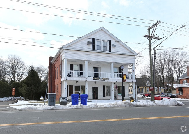
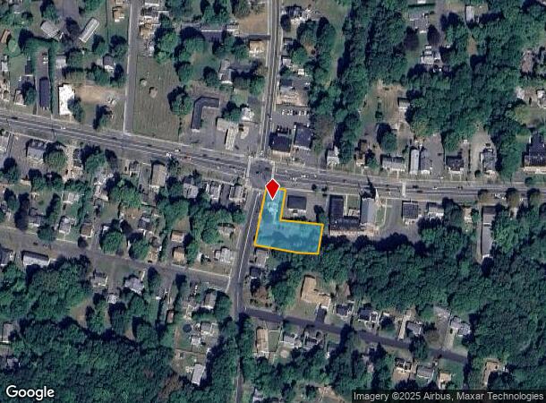
Property Record
312 Hazard Ave, Enfield, CT 06082

NEARBY LISTINGS FOR SALE OR LEASE
Property Detail
312 Hazard Ave
ENFI-000083-000000-000270
Hartford
Commercialbuilding
Connecticut
X
270
09003C0231F
0.28 AC
2025
Enfield
2025
Hartford
480800
Hartford-West Hartford-East Hartford, CT
4,683 SF
DEMOGRAPHICS near 312 Hazard Ave
1 mile
3 mile
5 mile
2024 Total Population
3,117
27,652
70,492
2029 Population
3,070
27,457
70,108
Pop Growth 2024-2029
(1.51%)
(0.71%)
(0.54%)
Average Age
44
43
43
2024 Total Households
1,385
11,045
26,337
HH Growth 2024-2029
(1.81%)
(0.92%)
(0.76%)
Median Household Inc
$86,458
$94,586
$94,972
Avg Household Size
2.20
2.40
2.40
2024 Avg HH Vehicles
2.00
2.00
2.00
Median Home Value
$231,752
$231,085
$261,976
Median Year Built
1963
1963
1964
Nearby Places
Map Layers
Map Styles
 Street
 Aerial
Transit
 Traffic
 Biking
Places
Listings with unknown addresses are not visible on the map
- Restaurants
- Banks
- Shops
- Fitness
- Groceries
PUBLIC TRANSPORTATION
COMMUTER RAIL
Windsor Locks (Hartford Line - CT Rail (CTRail))
Drive
Walk
Distance
Windsor Locks (Hartford Line - CT Rail (CTRail))
15 min
9.6 mi
AIRPORT
Bradley International
Drive
Walk
Distance
Bradley International
25 min
10.6 mi
Freight Ports
Port of New Haven
Drive
Walk
Distance
Port of New Haven
77 min
59.1 mi
SALE & LEASE HISTORY
LISTING DATE
SALE/LEASE

Mar 28, 2018
For Lease
Nearby Properties
Address
Land Use
TOTAL SIZE
Lot Size
Zoning
Address
Land Use
TOTAL SIZE
Lot Size
Zoning
179,293 SF
51.07 AC
HR33
Address
Land Use
TOTAL SIZE
Lot Size
Zoning
370.78 AC
R88
Address
Land Use
TOTAL SIZE
Lot Size
Zoning
283.30 AC
R88
Address
Land Use
TOTAL SIZE
Lot Size
Zoning
166,268 SF
36.70 AC
R44
Address
Land Use
TOTAL SIZE
Lot Size
Zoning
500,000 SF
71.20 AC
I-1
Address
Land Use
TOTAL SIZE
Lot Size
Zoning
201,978 SF
53.95 AC
R88
Address
Land Use
TOTAL SIZE
Lot Size
Zoning
121.07 AC
I-1
Address
Land Use
TOTAL SIZE
Lot Size
Zoning
32.97 AC
BR
Address
Land Use
TOTAL SIZE
Lot Size
Zoning
32.44 AC
BR
Address
Land Use
TOTAL SIZE
Lot Size
Zoning
49.16 AC
I-1
Address
Land Use
TOTAL SIZE
Lot Size
Zoning
319,054 SF
30.02 AC
I-P
Address
Land Use
TOTAL SIZE
Lot Size
Zoning
36.97 AC
I-1
Address
Land Use
TOTAL SIZE
Lot Size
Zoning
211,256 SF
41.58 AC
R33
Address
Land Use
TOTAL SIZE
Lot Size
Zoning
26.82 AC
HR33
Address
Land Use
TOTAL SIZE
Lot Size
Zoning
24.92 AC
BL
Address
Land Use
TOTAL SIZE
Lot Size
Zoning
13.87 AC
BR
Address
Land Use
TOTAL SIZE
Lot Size
Zoning
13.78 AC
BR
Address
Land Use
TOTAL SIZE
Lot Size
Zoning
1.87 AC
BP
Address
Land Use
TOTAL SIZE
Lot Size
Zoning
19.36 AC
BR
Address
Land Use
TOTAL SIZE
Lot Size
Zoning
144,625 SF
19 AC
BR
Address
Land Use
TOTAL SIZE
Lot Size
Zoning
12 AC
HR33
Address
Land Use
TOTAL SIZE
Lot Size
Zoning
17.34 AC
R44
Address
Land Use
TOTAL SIZE
Lot Size
Zoning
54.05 AC
I-1
Address
Land Use
TOTAL SIZE
Lot Size
Zoning
21.97 AC
I-1
Address
Land Use
TOTAL SIZE
Lot Size
Zoning
106,719 SF
3.76 AC
BR
Address
Land Use
TOTAL SIZE
Lot Size
Zoning
170,863 SF
18.38 AC
I-1
Address
Land Use
TOTAL SIZE
Lot Size
Zoning
125,406 SF
7.54 AC
BR
Address
Land Use
TOTAL SIZE
Lot Size
Zoning
13.85 AC
HR33
Address
Land Use
TOTAL SIZE
Lot Size
Zoning
15.91 AC
R44
Address
Land Use
TOTAL SIZE
Lot Size
Zoning
48,956 SF
4.78 AC
I-1
The World's #1 Commercial Real Estate Marketplace
Connect with us
© 2026 CoStar Group
The information above has been obtained from sources believed reliable. While we do not doubt its accuracy we have not verified it and make no guarantee, warranty or representation about it. It is your responsibility to independently confirm its accuracy and completeness. Any projections, opinions, assumptions, or estimates used are for example only and do not represent the current or future performance of the property. The value of this transaction to you depends on tax and other factors which should be evaluated by your tax, financial, and legal advisors. You and your advisors should conduct a careful, independent investigation of the property to determine to your satisfaction the suitability of the property for your needs.