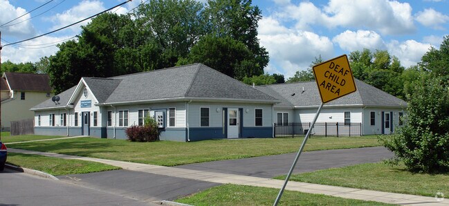
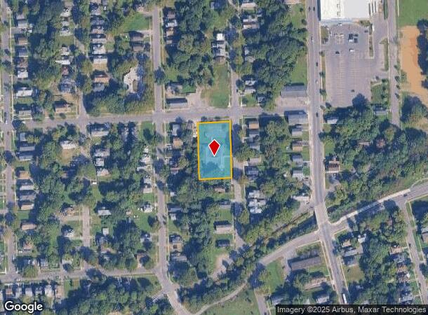
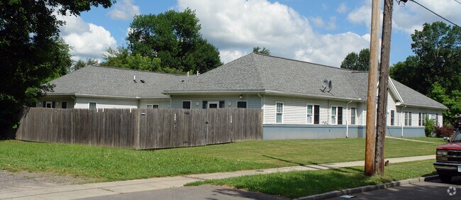
Property Record
312 Hudson St & Sterling Ave, Syracuse, NY 13205
NEARBY LISTINGS FOR SALE OR LEASE
Property Detail
312 Hudson St & Sterling Ave
311500-086-000-0022-002-001-0000
LOT 75B RESUB BLK 2 TR SOLVAY AMD #9137 231X132 WD APT
Apartment
Onondaga
AE
New York
36067C0216F
2.001
2025
0.70 AC
2024
Southside
006101
Syracuse
6,445 SF
Syracuse, NY
DEMOGRAPHICS near 312 Hudson St & Sterling Ave
1 Mile
3 Mile
5 Mile
2024 Total Population
22,899
135,910
217,189
2029 Population
22,659
133,223
212,462
Pop Growth 2024-2029
(1.05%)
(1.98%)
(2.18%)
Average Age
35
36
38
2024 Total Households
8,418
53,981
88,082
HH Growth 2024-2029
(1.16%)
(1.97%)
(2.24%)
Median Household Inc
$31,388
$39,134
$51,063
Avg Household Size
2.50
2.20
2.20
2024 Avg HH Vehicles
1.00
1.00
1.00
Median Home Value
$82,198
$135,509
$145,705
Median Year Built
1947
1950
1953
Nearby Places
- Restaurants
- Banks
- Shops
- Fitness
- Groceries
PUBLIC TRANSPORTATION
COMMUTER RAIL
DRIVE
WALK
Distance
8 min
3.9 mi
DRIVE
WALK
Distance
9 min
3.9 mi
AIRPORT
Syracuse Hancock International
DRIVE
WALK
Distance
Syracuse Hancock International
15 min
8.6 mi
Nearby Properties
Address
Land Use
TOTAL SIZE
Lot Size
Zoning
Address
Land Use
TOTAL SIZE
Lot Size
Zoning
70,284 SF
74.57 AC
25
Address
Land Use
TOTAL SIZE
Lot Size
Zoning
847,042 SF
42.78 AC
23
Address
Land Use
TOTAL SIZE
Lot Size
Zoning
57,011 SF
22.53 AC
22
Address
Land Use
TOTAL SIZE
Lot Size
Zoning
508,658 SF
2.23 AC
25
Address
Land Use
TOTAL SIZE
Lot Size
Zoning
848,000 SF
30.29 AC
Address
Land Use
TOTAL SIZE
Lot Size
Zoning
459,040 SF
4.71 AC
06 - INDUS
Address
Land Use
TOTAL SIZE
Lot Size
Zoning
12.08 AC
Address
Land Use
TOTAL SIZE
Lot Size
Zoning
826,528 SF
2.28 AC
06 - INDUS
Address
Land Use
TOTAL SIZE
Lot Size
Zoning
269,030 SF
11.90 AC
05 - COMME
Address
Land Use
TOTAL SIZE
Lot Size
Zoning
412,577 SF
39.43 AC
08 - GOVER
Address
Land Use
TOTAL SIZE
Lot Size
Zoning
348,998 SF
65.59 AC
25
Address
Land Use
TOTAL SIZE
Lot Size
Zoning
72,200 SF
12.39 AC
06 - INDUS
Address
Land Use
TOTAL SIZE
Lot Size
Zoning
354,492 SF
6.90 AC
25
Address
Land Use
TOTAL SIZE
Lot Size
Zoning
72,800 SF
1.89 AC
06 - INDUS
Address
Land Use
TOTAL SIZE
Lot Size
Zoning
409,062 SF
10
Address
Land Use
TOTAL SIZE
Lot Size
Zoning
522,469 SF
1.87 AC
14
Address
Land Use
TOTAL SIZE
Lot Size
Zoning
218,051 SF
2.32 AC
25
Address
Land Use
TOTAL SIZE
Lot Size
Zoning
6,598 SF
4.09 AC
14
Address
Land Use
TOTAL SIZE
Lot Size
Zoning
24,360 SF
3.99 AC
10
Address
Land Use
TOTAL SIZE
Lot Size
Zoning
108,368 SF
3.36 AC
14
Address
Land Use
TOTAL SIZE
Lot Size
Zoning
414,700 SF
1.94 AC
07 - MIXED
Address
Land Use
TOTAL SIZE
Lot Size
Zoning
2,709 SF
39.74 AC
06 - INDUS
Address
Land Use
TOTAL SIZE
Lot Size
Zoning
1.67 AC
06 - INDUS
Address
Land Use
TOTAL SIZE
Lot Size
Zoning
653,177 SF
1.94 AC
13
Address
Land Use
TOTAL SIZE
Lot Size
Zoning
224,736 SF
2.48 AC
10
Address
Land Use
TOTAL SIZE
Lot Size
Zoning
165,800 SF
1.27 AC
25
Address
Land Use
TOTAL SIZE
Lot Size
Zoning
164,837 SF
0.66 AC
10
Address
Land Use
TOTAL SIZE
Lot Size
Zoning
105,004 SF
2.81 AC
25
Address
Land Use
TOTAL SIZE
Lot Size
Zoning
316,848 SF
10.72 AC
08 - GOVER
Address
Land Use
TOTAL SIZE
Lot Size
Zoning
168,000 SF
2.18 AC
06 - INDUS
The World's #1 Commercial Real Estate Marketplace
Connect with us
© 2025 CoStar Group
The information above has been obtained from sources believed reliable. While we do not doubt its accuracy we have not verified it and make no guarantee, warranty or representation about it. It is your responsibility to independently confirm its accuracy and completeness. Any projections, opinions, assumptions, or estimates used are for example only and do not represent the current or future performance of the property. The value of this transaction to you depends on tax and other factors which should be evaluated by your tax, financial, and legal advisors. You and your advisors should conduct a careful, independent investigation of the property to determine to your satisfaction the suitability of the property for your needs.