Property Record
312 Linville Ridge Ct, Winston Salem, NC 27101
NEARBY LISTINGS FOR SALE OR LEASE
-
-
View all Winston Salem listings for sale on LoopNet.com
Property Detail
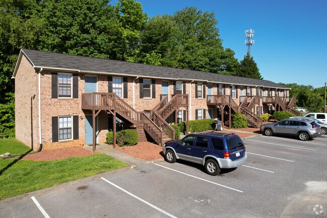
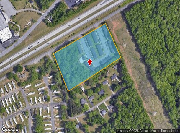
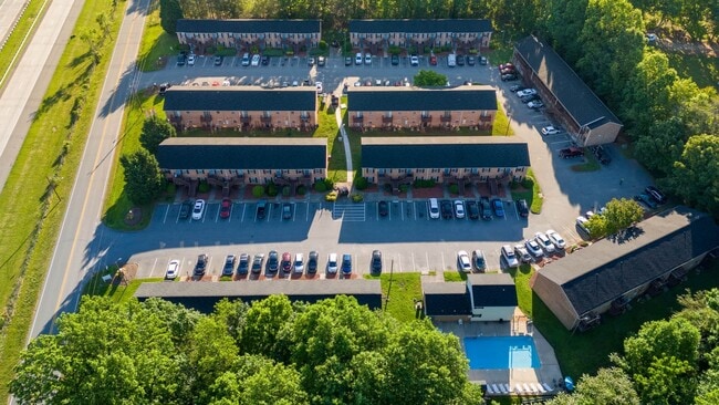
312 Linville Ridge Ct
Winston-Salem, NC
Linville Ridge Apartments
6856-40-7349
LINVILLE RIDGE APARTMENTS LO:101 BL:6169 BU:1
Apartment
Forsyth
X
North Carolina
3710685600J
101
2023
6.26 AC
2025
Southeast Winston-Salem
003309
Greensboro/Winston-Salem
34,496 SF
DEMOGRAPHICS near 312 Linville Ridge Ct
1 Mile
3 Mile
5 Mile
2024 Total Population
1,419
32,101
111,314
2029 Population
1,464
33,484
116,389
Pop Growth 2024-2029
+ 3.17%
+ 4.31%
+ 4.56%
Average Age
38
39
38
2024 Total Households
599
12,371
43,485
HH Growth 2024-2029
+ 3.01%
+ 4.33%
+ 4.66%
Median Household Inc
$36,551
$50,174
$49,064
Avg Household Size
2.40
2.50
2.40
2024 Avg HH Vehicles
2.00
2.00
2.00
Median Home Value
$235,555
$180,511
$178,474
Median Year Built
1983
1982
1977
Nearby Places
Map Layers
Map Styles
 Street
 Aerial
- Restaurants
- Banks
- Shops
- Fitness
- Groceries
PUBLIC TRANSPORTATION
AIRPORT
Piedmont Triad International
DRIVE
WALK
Distance
Piedmont Triad International
27 min
16.1 mi
Freight Ports
Virginia Port Authority - Richmond
DRIVE
WALK
Distance
Virginia Port Authority - Richmond
254 min
219.7 mi
Nearby Properties
Address
Land Use
TOTAL SIZE
Lot Size
Zoning
Address
Land Use
TOTAL SIZE
Lot Size
Zoning
188,273 SF
54.55 AC
IP
Address
Land Use
TOTAL SIZE
Lot Size
Zoning
1,182.87 AC
IP
Address
Land Use
TOTAL SIZE
Lot Size
Zoning
78,274 SF
27.95 AC
RM8-S
Address
Land Use
TOTAL SIZE
Lot Size
Zoning
98,617 SF
37.44 AC
RS20
Address
Land Use
TOTAL SIZE
Lot Size
Zoning
319,873 SF
35.01 AC
GI
Address
Land Use
TOTAL SIZE
Lot Size
Zoning
85,000 SF
48.02 AC
IP
Address
Land Use
TOTAL SIZE
Lot Size
Zoning
102,809 SF
16.74 AC
BI
Address
Land Use
TOTAL SIZE
Lot Size
Zoning
77,891 SF
20.91 AC
RS9
Address
Land Use
TOTAL SIZE
Lot Size
Zoning
66,245 SF
12.60 AC
RM12
Address
Land Use
TOTAL SIZE
Lot Size
Zoning
157,878 SF
11 AC
GI
Address
Land Use
TOTAL SIZE
Lot Size
Zoning
225,955 SF
64.68 AC
LI
Address
Land Use
TOTAL SIZE
Lot Size
Zoning
52,480 SF
30.51 AC
BI
Address
Land Use
TOTAL SIZE
Lot Size
Zoning
141,089 SF
16.31 AC
GI
Address
Land Use
TOTAL SIZE
Lot Size
Zoning
125,130 SF
11.23 AC
LI
Address
Land Use
TOTAL SIZE
Lot Size
Zoning
378,330 SF
74.78 AC
GI,GI-S,RS
Address
Land Use
TOTAL SIZE
Lot Size
Zoning
52,792 SF
25.21 AC
BI
Address
Land Use
TOTAL SIZE
Lot Size
Zoning
100 SF
12.10 AC
RM8-S
Address
Land Use
TOTAL SIZE
Lot Size
Zoning
15,300 SF
292.13 AC
IP,RM18,RS
Address
Land Use
TOTAL SIZE
Lot Size
Zoning
69,708 SF
16.10 AC
RM12
Address
Land Use
TOTAL SIZE
Lot Size
Zoning
49,396 SF
184.40 AC
GI-S,IP
Address
Land Use
TOTAL SIZE
Lot Size
Zoning
55,180 SF
17.35 AC
RM8-S
Address
Land Use
TOTAL SIZE
Lot Size
Zoning
73,868 SF
7.35 AC
IP
Address
Land Use
TOTAL SIZE
Lot Size
Zoning
73,732 SF
8.05 AC
IP
Address
Land Use
TOTAL SIZE
Lot Size
Zoning
40,944 SF
8.78 AC
RM18-S,RM8
Address
Land Use
TOTAL SIZE
Lot Size
Zoning
75,462 SF
14.51 AC
IP
Address
Land Use
TOTAL SIZE
Lot Size
Zoning
86,632 SF
6.99 AC
BI
Address
Land Use
TOTAL SIZE
Lot Size
Zoning
63,814 SF
18.93 AC
IP
Address
Land Use
TOTAL SIZE
Lot Size
Zoning
221,576 SF
39.69 AC
IP,RM12
Address
Land Use
TOTAL SIZE
Lot Size
Zoning
34,104 SF
7.82 AC
RM12-S
The World's #1 Commercial Real Estate Marketplace
Connect with us
© 2026 CoStar Group
The information above has been obtained from sources believed reliable. While we do not doubt its accuracy we have not verified it and make no guarantee, warranty or representation about it. It is your responsibility to independently confirm its accuracy and completeness. Any projections, opinions, assumptions, or estimates used are for example only and do not represent the current or future performance of the property. The value of this transaction to you depends on tax and other factors which should be evaluated by your tax, financial, and legal advisors. You and your advisors should conduct a careful, independent investigation of the property to determine to your satisfaction the suitability of the property for your needs.