Property Record
312 N Madison St, Hebron, IN 46341


NEARBY LISTINGS FOR SALE OR LEASE
-
-
View all Hebron listings for sale on LoopNet.com
Property Detail
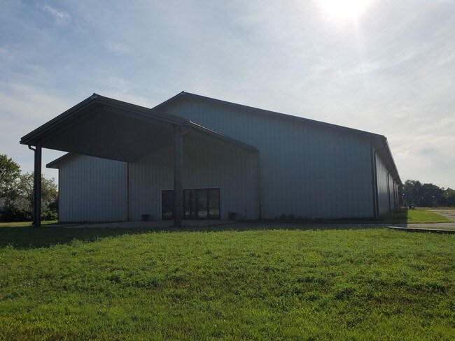
312 N Madison St
Chicago-Naperville-Elgin, IL-IN-WI
Frames 01 Add/Hebron
64-14-10-451-001.000-002
N 14 SW SE EX N OF RD 10-33-7 9.65A
Storebuilding
Porter
X
Indiana
18073C0005C
1
2023
44 SF
2024
Porter County
051101
Chicago
16,000 SF
DEMOGRAPHICS near 312 N Madison St
1 Mile
3 Mile
5 Mile
2024 Total Population
3,647
5,093
8,153
2029 Population
3,673
5,120
8,190
Pop Growth 2024-2029
+ 0.71%
+ 0.53%
+ 0.45%
Average Age
39
40
41
2024 Total Households
1,453
1,989
3,104
HH Growth 2024-2029
+ 0.69%
+ 0.55%
+ 0.45%
Median Household Inc
$74,999
$86,990
$93,863
Avg Household Size
2.50
2.60
2.60
2024 Avg HH Vehicles
2.00
2.00
2.00
Median Home Value
$155,704
$184,905
$235,686
Median Year Built
1974
1976
1979
Nearby Places
Map Layers
Map Styles
 Street
 Aerial
- Restaurants
- Banks
- Shops
- Fitness
- Groceries
SALE & LEASE HISTORY
LISTING DATE
SALE/LEASE

Aug 22, 2019
For Sale
Nearby Properties
Address
Land Use
TOTAL SIZE
Lot Size
Zoning
Address
Land Use
TOTAL SIZE
Lot Size
Zoning
83,708 SF
44 SF
Address
Land Use
TOTAL SIZE
Lot Size
Zoning
22,964 SF
9.86 AC
Address
Land Use
TOTAL SIZE
Lot Size
Zoning
27,756 SF
3.03 AC
Address
Land Use
TOTAL SIZE
Lot Size
Zoning
12,819 SF
0.77 AC
Address
Land Use
TOTAL SIZE
Lot Size
Zoning
21,656 SF
44 SF
Address
Land Use
TOTAL SIZE
Lot Size
Zoning
7,993 SF
23.24 AC
Address
Land Use
TOTAL SIZE
Lot Size
Zoning
20,868 SF
0.58 AC
Address
Land Use
TOTAL SIZE
Lot Size
Zoning
39,240 SF
44 SF
Address
Land Use
TOTAL SIZE
Lot Size
Zoning
12,729 SF
1.43 AC
Address
Land Use
TOTAL SIZE
Lot Size
Zoning
5,428 SF
25 AC
R33
Address
Land Use
TOTAL SIZE
Lot Size
Zoning
7,137 SF
27.12 AC
Address
Land Use
TOTAL SIZE
Lot Size
Zoning
7,424 SF
10 AC
Address
Land Use
TOTAL SIZE
Lot Size
Zoning
6,398 SF
87 SF
Address
Land Use
TOTAL SIZE
Lot Size
Zoning
9,783 SF
9.89 AC
Address
Land Use
TOTAL SIZE
Lot Size
Zoning
25,068 SF
Address
Land Use
TOTAL SIZE
Lot Size
Zoning
6,052 SF
0.82 AC
Address
Land Use
TOTAL SIZE
Lot Size
Zoning
9,720 SF
1.56 AC
Address
Land Use
TOTAL SIZE
Lot Size
Zoning
15,480 SF
0.66 AC
Address
Land Use
TOTAL SIZE
Lot Size
Zoning
5,412 SF
9.84 AC
Address
Land Use
TOTAL SIZE
Lot Size
Zoning
14,646 SF
18.45 AC
Address
Land Use
TOTAL SIZE
Lot Size
Zoning
7,404 SF
44 SF
Address
Land Use
TOTAL SIZE
Lot Size
Zoning
5,067 SF
44 SF
Address
Land Use
TOTAL SIZE
Lot Size
Zoning
14,904 SF
0.83 AC
Address
Land Use
TOTAL SIZE
Lot Size
Zoning
3,186 SF
240.32 AC
Address
Land Use
TOTAL SIZE
Lot Size
Zoning
4,887 SF
13.28 AC
R33
Address
Land Use
TOTAL SIZE
Lot Size
Zoning
5,824 SF
87 SF
Address
Land Use
TOTAL SIZE
Lot Size
Zoning
6,242 SF
87 SF
Address
Land Use
TOTAL SIZE
Lot Size
Zoning
3.06 AC
Address
Land Use
TOTAL SIZE
Lot Size
Zoning
1,700 SF
1.03 AC
The World's #1 Commercial Real Estate Marketplace
Connect with us
© 2025 CoStar Group
The information above has been obtained from sources believed reliable. While we do not doubt its accuracy we have not verified it and make no guarantee, warranty or representation about it. It is your responsibility to independently confirm its accuracy and completeness. Any projections, opinions, assumptions, or estimates used are for example only and do not represent the current or future performance of the property. The value of this transaction to you depends on tax and other factors which should be evaluated by your tax, financial, and legal advisors. You and your advisors should conduct a careful, independent investigation of the property to determine to your satisfaction the suitability of the property for your needs.