No Photo
Property Record
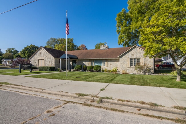
312 Pine St, Elk Rapids, MI 49629


Property Detail
312 Pine St
Other Market Areas
LOTS 194 AND 195 PLAT OF THE VILL OF ELK RAPIDS. SEC 20 T29N R9W
05-43-010-178-00
ANTRIM
Commercialnec
Michigan
2025
194-195
2025
0.38 AC
960600
Michigan North Central Area
NEARBY LISTINGS FOR SALE OR LEASE
-
-
View all Elk Rapids listings for sale on LoopNet.com
DEMOGRAPHICS near 312 Pine St
1 mile
3 mile
5 mile
2025 Total Population
1,541
3,135
6,405
2030 Population
1,619
3,334
6,787
Pop Growth 2025-2030
+ 5.06%
+ 6.35%
+ 5.96%
Average Age
51
51
50
2025 Total Households
727
1,486
2,916
HH Growth 2025-2030
+ 5.23%
+ 6.39%
+ 6.07%
Median Household Inc
$81,136
$81,465
$88,636
Avg Household Size
2.10
2.10
2.20
2025 Avg HH Vehicles
2.00
2.00
2.00
Median Home Value
$384,306
$384,408
$475,320
Median Year Built
1973
1977
1982
Nearby Places
Map Layers
Map Styles
 Street
 Aerial
Layers
 Traffic
 Biking
Places
Listings with unknown addresses are not visible on the map
- Restaurants
- Banks
- Shops
- Fitness
- Groceries
PUBLIC TRANSPORTATION
AIRPORT
Cherry Capital
Drive
Walk
Distance
Cherry Capital
29 min
16.2 mi
SALE & LEASE HISTORY
LISTING DATE
SALE/LEASE

Sep 27, 2024
For Sale
Apr 18, 2025
For Sale
Nearby Properties
Address
Land Use
TOTAL SIZE
Lot Size
Zoning
Address
Land Use
TOTAL SIZE
Lot Size
Zoning
9.81 AC
Address
Land Use
TOTAL SIZE
Lot Size
Zoning
Address
Land Use
TOTAL SIZE
Lot Size
Zoning
2,695 SF
67.50 AC
Address
Land Use
TOTAL SIZE
Lot Size
Zoning
0.30 AC
Address
Land Use
TOTAL SIZE
Lot Size
Zoning
7,951 SF
54.72 AC
Address
Land Use
TOTAL SIZE
Lot Size
Zoning
2.97 AC
Address
Land Use
TOTAL SIZE
Lot Size
Zoning
17,188 SF
1.05 AC
Address
Land Use
TOTAL SIZE
Lot Size
Zoning
2.88 AC
Address
Land Use
TOTAL SIZE
Lot Size
Zoning
3.44 AC
Address
Land Use
TOTAL SIZE
Lot Size
Zoning
11.54 AC
Address
Land Use
TOTAL SIZE
Lot Size
Zoning
Address
Land Use
TOTAL SIZE
Lot Size
Zoning
1.17 AC
Address
Land Use
TOTAL SIZE
Lot Size
Zoning
12.78 AC
Address
Land Use
TOTAL SIZE
Lot Size
Zoning
17,885 SF
1.72 AC
Address
Land Use
TOTAL SIZE
Lot Size
Zoning
1.14 AC
Address
Land Use
TOTAL SIZE
Lot Size
Zoning
Address
Land Use
TOTAL SIZE
Lot Size
Zoning
79.80 AC
Address
Land Use
TOTAL SIZE
Lot Size
Zoning
6,084 SF
0.07 AC
Address
Land Use
TOTAL SIZE
Lot Size
Zoning
122.98 AC
Address
Land Use
TOTAL SIZE
Lot Size
Zoning
0.90 AC
Address
Land Use
TOTAL SIZE
Lot Size
Zoning
0.18 AC
Address
Land Use
TOTAL SIZE
Lot Size
Zoning
28,360 SF
3.50 AC
Address
Land Use
TOTAL SIZE
Lot Size
Zoning
Address
Land Use
TOTAL SIZE
Lot Size
Zoning
10,764 SF
3.79 AC
Address
Land Use
TOTAL SIZE
Lot Size
Zoning
Address
Land Use
TOTAL SIZE
Lot Size
Zoning
0.65 AC
Address
Land Use
TOTAL SIZE
Lot Size
Zoning
0.20 AC
Address
Land Use
TOTAL SIZE
Lot Size
Zoning
1.04 AC
Address
Land Use
TOTAL SIZE
Lot Size
Zoning
45,294 SF
1.96 AC
Address
Land Use
TOTAL SIZE
Lot Size
Zoning
0.98 AC
The World's #1 Commercial Real Estate Marketplace
Connect with us
© 2026 CoStar Group
The information above has been obtained from sources believed reliable. While we do not doubt its accuracy we have not verified it and make no guarantee, warranty or representation about it. It is your responsibility to independently confirm its accuracy and completeness. Any projections, opinions, assumptions, or estimates used are for example only and do not represent the current or future performance of the property. The value of this transaction to you depends on tax and other factors which should be evaluated by your tax, financial, and legal advisors. You and your advisors should conduct a careful, independent investigation of the property to determine to your satisfaction the suitability of the property for your needs.