Property Record
312 Riley Ave, Ogden, KS 66517
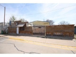


This Property Is For Sale
Property Detail
312 Riley Ave
251-12-0-10-12-004.00-0
OGDEN CITY, BLOCK 18, LOT 6 - 7
Warehouse
Riley
MU
Kansas
B and X Area of moderate flood hazard, usually the area between the limits of the 100-year and 500-year floods.
6,7
2025
0.17 AC
2025
Kansas Area
000900
Other Market Areas
3,807 SF
Manhattan, KS
NEARBY LISTINGS FOR SALE OR LEASE
-
-
View all Ogden listings for sale on LoopNet.com
DEMOGRAPHICS near 312 Riley Ave
1 mile
3 mile
5 mile
2025 Total Population
1,411
1,947
5,331
2030 Population
1,358
1,890
5,272
Pop Growth 2025-2030
(3.76%)
(2.93%)
(1.11%)
Average Age
37
36
29
2025 Total Households
595
717
1,677
HH Growth 2025-2030
(4.03%)
(3.63%)
(1.43%)
Median Household Inc
$58,628
$61,351
$53,444
Avg Household Size
2.30
2.40
2.60
2025 Avg HH Vehicles
2.00
2.00
2.00
Median Home Value
$181,249
$185,616
$200,305
Median Year Built
1986
1987
1994
Nearby Places
Map Layers
Map Styles
 Street
 Aerial
Layers
 Traffic
 Biking
Places
Listings with unknown addresses are not visible on the map
- Restaurants
- Banks
- Shops
- Fitness
- Groceries
PUBLIC TRANSPORTATION
AIRPORT
Manhattan Regional
Drive
Walk
Distance
Manhattan Regional
9 min
3.4 mi
Nearby Properties
Address
Land Use
TOTAL SIZE
Lot Size
Zoning
Address
Land Use
TOTAL SIZE
Lot Size
Zoning
23,900 SF
4.51 AC
I3
Address
Land Use
TOTAL SIZE
Lot Size
Zoning
42,878 SF
8.75 AC
I5
Address
Land Use
TOTAL SIZE
Lot Size
Zoning
43,406 SF
2.30 AC
R1
Address
Land Use
TOTAL SIZE
Lot Size
Zoning
200,158 SF
20.07 AC
I3
Address
Land Use
TOTAL SIZE
Lot Size
Zoning
6,579 SF
88.68 AC
C1
Address
Land Use
TOTAL SIZE
Lot Size
Zoning
14,401 SF
5.90 AC
PU
Address
Land Use
TOTAL SIZE
Lot Size
Zoning
53,602 SF
5.85 AC
I3
Address
Land Use
TOTAL SIZE
Lot Size
Zoning
665.74 AC
FORT
Address
Land Use
TOTAL SIZE
Lot Size
Zoning
646.23 AC
FORT
Address
Land Use
TOTAL SIZE
Lot Size
Zoning
643.43 AC
FORT
Address
Land Use
TOTAL SIZE
Lot Size
Zoning
67,328 SF
9.13 AC
I5
Address
Land Use
TOTAL SIZE
Lot Size
Zoning
541.33 AC
FORT
Address
Land Use
TOTAL SIZE
Lot Size
Zoning
40,000 SF
8.56 AC
I3
Address
Land Use
TOTAL SIZE
Lot Size
Zoning
6,000 SF
14.80 AC
I3
Address
Land Use
TOTAL SIZE
Lot Size
Zoning
3,071 SF
2.43 AC
R1
Address
Land Use
TOTAL SIZE
Lot Size
Zoning
326.90 AC
AG
Address
Land Use
TOTAL SIZE
Lot Size
Zoning
0.54 AC
PU
Address
Land Use
TOTAL SIZE
Lot Size
Zoning
3,264 SF
0.25 AC
R1
Address
Land Use
TOTAL SIZE
Lot Size
Zoning
156.60 AC
FORT
Address
Land Use
TOTAL SIZE
Lot Size
Zoning
864 SF
0.31 AC
MU
Address
Land Use
TOTAL SIZE
Lot Size
Zoning
10,923 SF
371.96 AC
AO
Address
Land Use
TOTAL SIZE
Lot Size
Zoning
9,425 SF
1.61 AC
MU
Address
Land Use
TOTAL SIZE
Lot Size
Zoning
47.51 AC
PU
Address
Land Use
TOTAL SIZE
Lot Size
Zoning
1,792 SF
0.17 AC
MU
Address
Land Use
TOTAL SIZE
Lot Size
Zoning
3,979 SF
5.40 AC
Address
Land Use
TOTAL SIZE
Lot Size
Zoning
10,000 SF
4.46 AC
I3
Address
Land Use
TOTAL SIZE
Lot Size
Zoning
52.92 AC
A
Address
Land Use
TOTAL SIZE
Lot Size
Zoning
47.91 AC
A
Address
Land Use
TOTAL SIZE
Lot Size
Zoning
737 SF
0.80 AC
PU
Address
Land Use
TOTAL SIZE
Lot Size
Zoning
5,460 SF
0.30 AC
MU
The World's #1 Commercial Real Estate Marketplace
Connect with us
© 2026 CoStar Group
The information above has been obtained from sources believed reliable. While we do not doubt its accuracy we have not verified it and make no guarantee, warranty or representation about it. It is your responsibility to independently confirm its accuracy and completeness. Any projections, opinions, assumptions, or estimates used are for example only and do not represent the current or future performance of the property. The value of this transaction to you depends on tax and other factors which should be evaluated by your tax, financial, and legal advisors. You and your advisors should conduct a careful, independent investigation of the property to determine to your satisfaction the suitability of the property for your needs.