Property Record
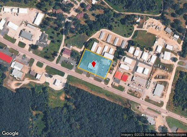
312 S Main St, Gravois Mills, MO 65037

NEARBY LISTINGS FOR SALE OR LEASE
Property Detail
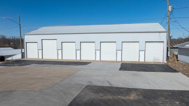
312 S Main St
208028000000034000
Pleasant View - Laurie
Restaurantbuilding
LOTS 4,5,6 PLEASANT VIEW - LAURIE 200 X 300
X
Morgan
29029C0080C
Missouri
2024
4,5,6
2025
1.37 AC
470503
Missouri South Central Area
3,436 SF
Other Market Areas
DEMOGRAPHICS near 312 S Main St
1 Mile
3 Mile
5 Mile
2024 Total Population
424
2,603
9,372
2029 Population
457
2,822
10,293
Pop Growth 2024-2029
+ 7.78%
+ 8.41%
+ 9.83%
Average Age
51
51
53
2024 Total Households
198
1,232
4,406
HH Growth 2024-2029
+ 6.57%
+ 7.47%
+ 8.99%
Median Household Inc
$55,000
$51,266
$59,965
Avg Household Size
2.10
2.10
2.10
2024 Avg HH Vehicles
2.00
2.00
2.00
Median Home Value
$226,316
$232,258
$262,166
Median Year Built
1986
1986
1987
Nearby Places
Map Layers
Map Styles
 Street
 Aerial
- Restaurants
- Banks
- Shops
- Fitness
- Groceries
SALE & LEASE HISTORY
LISTING DATE
SALE/LEASE

Apr 05, 2024
For Sale
Nearby Properties
Address
Land Use
TOTAL SIZE
Lot Size
Zoning
Address
Land Use
TOTAL SIZE
Lot Size
Zoning
27,152 SF
9.33 AC
Address
Land Use
TOTAL SIZE
Lot Size
Zoning
38,860 SF
1.50 AC
Address
Land Use
TOTAL SIZE
Lot Size
Zoning
17,326 SF
14 AC
Address
Land Use
TOTAL SIZE
Lot Size
Zoning
Address
Land Use
TOTAL SIZE
Lot Size
Zoning
4,844 SF
1.38 AC
Address
Land Use
TOTAL SIZE
Lot Size
Zoning
21,667 SF
4.23 AC
Address
Land Use
TOTAL SIZE
Lot Size
Zoning
5,134 SF
1.60 AC
Address
Land Use
TOTAL SIZE
Lot Size
Zoning
4,232 SF
1.10 AC
Address
Land Use
TOTAL SIZE
Lot Size
Zoning
35,244 SF
183.21 AC
Address
Land Use
TOTAL SIZE
Lot Size
Zoning
26,500 SF
3.20 AC
Address
Land Use
TOTAL SIZE
Lot Size
Zoning
8,879 SF
2.06 AC
Address
Land Use
TOTAL SIZE
Lot Size
Zoning
11,610 SF
0.87 AC
Address
Land Use
TOTAL SIZE
Lot Size
Zoning
5,130 SF
1.70 AC
Address
Land Use
TOTAL SIZE
Lot Size
Zoning
13,858 SF
4.43 AC
Address
Land Use
TOTAL SIZE
Lot Size
Zoning
Address
Land Use
TOTAL SIZE
Lot Size
Zoning
14,800 SF
2.98 AC
Address
Land Use
TOTAL SIZE
Lot Size
Zoning
10,752 SF
4.69 AC
Address
Land Use
TOTAL SIZE
Lot Size
Zoning
Address
Land Use
TOTAL SIZE
Lot Size
Zoning
Address
Land Use
TOTAL SIZE
Lot Size
Zoning
13,989 SF
4.90 AC
Address
Land Use
TOTAL SIZE
Lot Size
Zoning
9,230 SF
1.21 AC
Address
Land Use
TOTAL SIZE
Lot Size
Zoning
3,300 SF
1.60 AC
Address
Land Use
TOTAL SIZE
Lot Size
Zoning
14,300 SF
2.25 AC
Address
Land Use
TOTAL SIZE
Lot Size
Zoning
8,960 SF
0.92 AC
Address
Land Use
TOTAL SIZE
Lot Size
Zoning
6,364 SF
0.26 AC
Address
Land Use
TOTAL SIZE
Lot Size
Zoning
5,544 SF
1.70 AC
Address
Land Use
TOTAL SIZE
Lot Size
Zoning
3,888 SF
1.49 AC
Address
Land Use
TOTAL SIZE
Lot Size
Zoning
31,040 SF
3.95 AC
Address
Land Use
TOTAL SIZE
Lot Size
Zoning
116.10 AC
The World's #1 Commercial Real Estate Marketplace
Connect with us
© 2025 CoStar Group
The information above has been obtained from sources believed reliable. While we do not doubt its accuracy we have not verified it and make no guarantee, warranty or representation about it. It is your responsibility to independently confirm its accuracy and completeness. Any projections, opinions, assumptions, or estimates used are for example only and do not represent the current or future performance of the property. The value of this transaction to you depends on tax and other factors which should be evaluated by your tax, financial, and legal advisors. You and your advisors should conduct a careful, independent investigation of the property to determine to your satisfaction the suitability of the property for your needs.