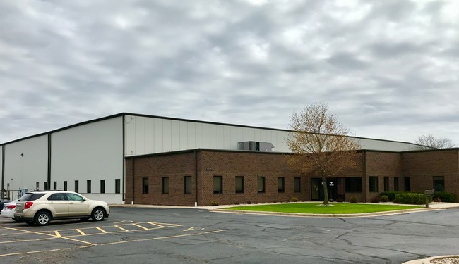
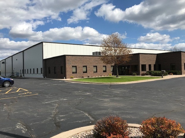
Property Record
3120 N Marshall Rd, Appleton, WI 54911

Property Detail
3120 N Marshall Rd
31-1-5309-00
NORTHEAST INDUSTRIAL P ARK PLAT NO 1 LOT 1 BLK 7 LESS S506.51FT LESS N20FT THEREOF 7.415AC M/L STATE ASSESSED
Industrialgeneral
Outagamie
M1
Wisconsin
B and X Area of moderate flood hazard, usually the area between the limits of the 100-year and 500-year floods.
1
2024
7.42 AC
2024
Outagamie County
011502
Green Bay
105,126 SF
Appleton, WI
NEARBY LISTINGS FOR SALE OR LEASE
DEMOGRAPHICS near 3120 N Marshall Rd
1 mile
3 mile
5 mile
2025 Total Population
2,457
66,022
150,975
2030 Population
2,496
67,556
154,279
Pop Growth 2025-2030
+ 1.59%
+ 2.32%
+ 2.19%
Average Age
41
40
40
2025 Total Households
1,120
27,278
61,508
HH Growth 2025-2030
+ 1.70%
+ 2.54%
+ 2.28%
Median Household Inc
$81,300
$79,832
$82,611
Avg Household Size
2.20
2.30
2.40
2025 Avg HH Vehicles
2.00
2.00
2.00
Median Home Value
$267,134
$253,319
$258,718
Median Year Built
1977
1975
1979
Nearby Places
Map Layers
Map Styles
 Street
 Aerial
Transit
 Traffic
 Biking
Places
Listings with unknown addresses are not visible on the map
- Restaurants
- Banks
- Shops
- Fitness
- Groceries
PUBLIC TRANSPORTATION
AIRPORT
Appleton International
Drive
Walk
Distance
Appleton International
18 min
11.1 mi
Green Bay/Austin Straubel International
Drive
Walk
Distance
Green Bay/Austin Straubel International
32 min
24.1 mi
Freight Ports
Port Milwaukee
Drive
Walk
Distance
Port Milwaukee
132 min
112.9 mi
SALE & LEASE HISTORY
LISTING DATE
SALE/LEASE

Nov 27, 2019
For Sale
May 07, 2019
For Lease
Nearby Properties
Address
Land Use
TOTAL SIZE
Lot Size
Zoning
Address
Land Use
TOTAL SIZE
Lot Size
Zoning
154,889 SF
1 AC
C2
Address
Land Use
TOTAL SIZE
Lot Size
Zoning
33.54 AC
Address
Land Use
TOTAL SIZE
Lot Size
Zoning
500,700 SF
47.17 AC
Address
Land Use
TOTAL SIZE
Lot Size
Zoning
189,107 SF
13.37 AC
Address
Land Use
TOTAL SIZE
Lot Size
Zoning
3.42 AC
PDC2
Address
Land Use
TOTAL SIZE
Lot Size
Zoning
84,620 SF
92.18 AC
C2
Address
Land Use
TOTAL SIZE
Lot Size
Zoning
20.37 AC
PDC2
Address
Land Use
TOTAL SIZE
Lot Size
Zoning
70,136 SF
6.34 AC
C2
Address
Land Use
TOTAL SIZE
Lot Size
Zoning
2,032 SF
18.48 AC
R3
Address
Land Use
TOTAL SIZE
Lot Size
Zoning
65,818 SF
8.01 AC
C2
Address
Land Use
TOTAL SIZE
Lot Size
Zoning
16.63 AC
Address
Land Use
TOTAL SIZE
Lot Size
Zoning
6.59 AC
M1
Address
Land Use
TOTAL SIZE
Lot Size
Zoning
29,742 SF
5.95 AC
R3
Address
Land Use
TOTAL SIZE
Lot Size
Zoning
13.05 AC
Address
Land Use
TOTAL SIZE
Lot Size
Zoning
194,573 SF
19.99 AC
Address
Land Use
TOTAL SIZE
Lot Size
Zoning
Address
Land Use
TOTAL SIZE
Lot Size
Zoning
Address
Land Use
TOTAL SIZE
Lot Size
Zoning
53,321 SF
2.51 AC
CBD
Address
Land Use
TOTAL SIZE
Lot Size
Zoning
44,164 SF
0.62 AC
CBD
Address
Land Use
TOTAL SIZE
Lot Size
Zoning
17.43 AC
M2
Address
Land Use
TOTAL SIZE
Lot Size
Zoning
13.11 AC
Address
Land Use
TOTAL SIZE
Lot Size
Zoning
40,560 SF
6.67 AC
R3
Address
Land Use
TOTAL SIZE
Lot Size
Zoning
107,202 SF
39.98 AC
C2
Address
Land Use
TOTAL SIZE
Lot Size
Zoning
66,504 SF
5.25 AC
C2
Address
Land Use
TOTAL SIZE
Lot Size
Zoning
14,024 SF
9.34 AC
PDR3
Address
Land Use
TOTAL SIZE
Lot Size
Zoning
5.10 AC
Address
Land Use
TOTAL SIZE
Lot Size
Zoning
6.66 AC
Address
Land Use
TOTAL SIZE
Lot Size
Zoning
20.22 AC
M1
Address
Land Use
TOTAL SIZE
Lot Size
Zoning
16,664 SF
8.48 AC
PDR3
Address
Land Use
TOTAL SIZE
Lot Size
Zoning
The World's #1 Commercial Real Estate Marketplace
Connect with us
© 2026 CoStar Group
The information above has been obtained from sources believed reliable. While we do not doubt its accuracy we have not verified it and make no guarantee, warranty or representation about it. It is your responsibility to independently confirm its accuracy and completeness. Any projections, opinions, assumptions, or estimates used are for example only and do not represent the current or future performance of the property. The value of this transaction to you depends on tax and other factors which should be evaluated by your tax, financial, and legal advisors. You and your advisors should conduct a careful, independent investigation of the property to determine to your satisfaction the suitability of the property for your needs.