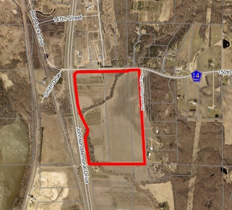
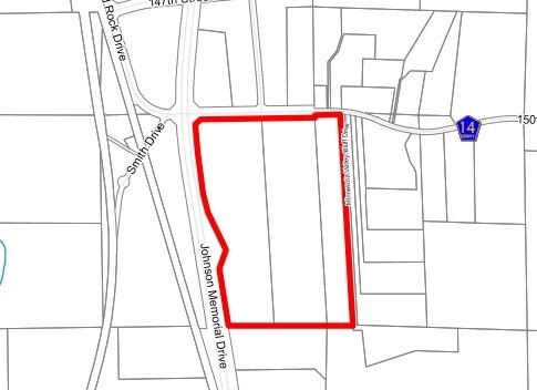
Property Record
3121 150Th St W, Shakopee, MN 55379
NEARBY LISTINGS FOR SALE OR LEASE
-
-
View all Shakopee listings for sale on LoopNet.com
Property Detail
3121 150Th St W
Minneapolis-St. Paul-Bloomington, MN-WI
SECTION 33 TOWNSHIP 115 RANGE 023
7-933-011-1
Scott
Commercialacreage
Minnesota
2025
39.55 AC
2025
Scott County Outlying
080307
Minneapolis/St Paul
DEMOGRAPHICS near 3121 150Th St W
1 Mile
3 Mile
5 Mile
2024 Total Population
89
2,822
39,801
2029 Population
98
3,095
43,075
Pop Growth 2024-2029
+ 10.11%
+ 9.67%
+ 8.23%
Average Age
40
39
37
2024 Total Households
30
941
13,577
HH Growth 2024-2029
+ 10.00%
+ 9.88%
+ 8.30%
Median Household Inc
$124,999
$103,030
$97,884
Avg Household Size
2.90
3.00
2.80
2024 Avg HH Vehicles
3.00
3.00
2.00
Median Home Value
$535,714
$437,577
$343,157
Median Year Built
1996
1992
1995
Nearby Places
Map Layers
Map Styles
 Street
 Aerial
- Restaurants
- Banks
- Shops
- Fitness
- Groceries
PUBLIC TRANSPORTATION
AIRPORT
Minneapolis-St Paul International/Wold-Chamberlain
DRIVE
WALK
Distance
Minneapolis-St Paul International/Wold-Chamberlain
39 min
27.0 mi
Freight Ports
Port Milwaukee
DRIVE
WALK
Distance
Port Milwaukee
406 min
362.1 mi
Nearby Properties
Address
Land Use
TOTAL SIZE
Lot Size
Zoning
Address
Land Use
TOTAL SIZE
Lot Size
Zoning
119.59 AC
I-2
Address
Land Use
TOTAL SIZE
Lot Size
Zoning
92,380 SF
20.05 AC
I-2
Address
Land Use
TOTAL SIZE
Lot Size
Zoning
33,836 SF
10.50 AC
I-2
Address
Land Use
TOTAL SIZE
Lot Size
Zoning
157.60 AC
I-1
Address
Land Use
TOTAL SIZE
Lot Size
Zoning
67,789 SF
5.18 AC
I-2
Address
Land Use
TOTAL SIZE
Lot Size
Zoning
2,610 SF
365.40 AC
Address
Land Use
TOTAL SIZE
Lot Size
Zoning
79,250 SF
6.60 AC
C-1
Address
Land Use
TOTAL SIZE
Lot Size
Zoning
50,470 SF
13.14 AC
I-2
Address
Land Use
TOTAL SIZE
Lot Size
Zoning
57,066 SF
9.44 AC
I-1
Address
Land Use
TOTAL SIZE
Lot Size
Zoning
91.80 AC
I-2
Address
Land Use
TOTAL SIZE
Lot Size
Zoning
34,228 SF
5.90 AC
C-1
Address
Land Use
TOTAL SIZE
Lot Size
Zoning
17,863 SF
28 AC
I-2
Address
Land Use
TOTAL SIZE
Lot Size
Zoning
19,798 SF
9.56 AC
UBR
Address
Land Use
TOTAL SIZE
Lot Size
Zoning
100.80 AC
I-2
Address
Land Use
TOTAL SIZE
Lot Size
Zoning
111.09 AC
I-2
Address
Land Use
TOTAL SIZE
Lot Size
Zoning
38,049 SF
7.98 AC
C-1
Address
Land Use
TOTAL SIZE
Lot Size
Zoning
5.01 AC
C-1
Address
Land Use
TOTAL SIZE
Lot Size
Zoning
50 AC
I-1
Address
Land Use
TOTAL SIZE
Lot Size
Zoning
27,827 SF
4.34 AC
C-1
Address
Land Use
TOTAL SIZE
Lot Size
Zoning
52,277 SF
4.34 AC
I-1
Address
Land Use
TOTAL SIZE
Lot Size
Zoning
37,981 SF
11.36 AC
UBR
Address
Land Use
TOTAL SIZE
Lot Size
Zoning
17.10 AC
I-1
Address
Land Use
TOTAL SIZE
Lot Size
Zoning
8,800 SF
10.94 AC
I-2
Address
Land Use
TOTAL SIZE
Lot Size
Zoning
10.48 AC
C-1
Address
Land Use
TOTAL SIZE
Lot Size
Zoning
36,100 SF
5.16 AC
I-2
Address
Land Use
TOTAL SIZE
Lot Size
Zoning
26,180 SF
2.73 AC
I-1
Address
Land Use
TOTAL SIZE
Lot Size
Zoning
23,800 SF
7.83 AC
I-1
Address
Land Use
TOTAL SIZE
Lot Size
Zoning
26,893 SF
2.97 AC
I-1
Address
Land Use
TOTAL SIZE
Lot Size
Zoning
80.99 AC
UER
The World's #1 Commercial Real Estate Marketplace
Connect with us
© 2026 CoStar Group
The information above has been obtained from sources believed reliable. While we do not doubt its accuracy we have not verified it and make no guarantee, warranty or representation about it. It is your responsibility to independently confirm its accuracy and completeness. Any projections, opinions, assumptions, or estimates used are for example only and do not represent the current or future performance of the property. The value of this transaction to you depends on tax and other factors which should be evaluated by your tax, financial, and legal advisors. You and your advisors should conduct a careful, independent investigation of the property to determine to your satisfaction the suitability of the property for your needs.